九龍公園徑
22°17′53.7324″N 114°10′10.4046″E / 22.298259000°N 114.169556833°E
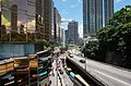
 晚上的九龍公園徑 (2015年) | |
| 道路長度 | 700米(2,300英尺) |
| 车速限制 | 50公里每小時 |
| 车道数 | 四線雙程(2線雙程分隔) |
| 地點 | 香港九龍西油尖旺區 |
| 起點 | 尖沙咀梳士巴利道 |
| 終點 | 尖沙咀廣東道 |
| 建造 | |
| 动工 | 1970年代 |
| 通車日期 | 1970年代 |
九龍公園徑(英語:Kowloon Park Drive),是香港九龍尖沙咀的一條道路,位於九龍公園西側,南起梳士巴利道近舊尖沙咀消防局及香港基督教青年會總部,北接廣東道近中港城。道路部份為高架設計,跨越海防道。
九龍公園徑是於1970年代初政府把威菲路軍營改為九龍公園時修築的,4線南北雙向行車。九龍公園徑開發於1970年代初,當九龍公園開闢後,當局才在公園旁開一條捷徑,來往九龍公園,故有九龍公園徑之命名。[1]
-
 九龍公園徑北端近中港城
 -
 九龍公園徑近香港文物探知館
 -
 九龍公園徑南端近1881 Heritage


交通
九龍新界巴士
| 3X | 慈雲山(北) | → ← |
中港碼頭 佐敦(西九龍站) |
只限平日繁忙時間服務 |
| 12 | 海麗邨 | ⇄ | 尖沙咀東(麼地道) | |
| 20A | 高鐵西九龍站 | ⇄ | 啟德郵輪碼頭 | |
| 50 | 屯門(菁田及和田) | ⇄ | 尖沙咀(九龍站) | |
| 215P | 藍田(廣田邨) | → | 九龍站 | 只限平日上午繁忙時間服務 |
| 215X | 藍田(廣田邨) | ⇄ | 九龍站 | |
| 261B | 屯門(三聖邨) | → | 九龍站 | 只限平日上午繁忙時間服務 |
| 271 | 大埔(富亨) | ⇄ | 佐敦(西九龍站) | |
| 271A | 富蝶總站 | ⇄ | 尖沙咀東(麼地道) | 只限平日繁忙時間服務 |
| 271B | 大埔(富亨) | ⇄ | 佐敦(西九龍站) | 只限平日繁忙時間服務 |
| 271P | 九龍坑 | → | 尖沙咀(廣東道) | 只限平日上午繁忙時間服務 |
| 281A | 沙田(廣源) | ⇄ | 九龍站 | |
| 296D | 尚德 | ⇄ | 九龍站 | |
| T270 | 粉嶺(祥華) | ⇄ | 尖沙咀東(麼地道) | 只限平日繁忙時間服務 |
- 居民巴士
新界居民巴士
| NR28 | 康盛花園 | ⇄ | 尖沙咀(漢口道) | 只限平日繁忙時間服務 |
| NR30 | 千里台 | → | 紅磡站 | 只限平日上午繁忙時間服務 |
| NR41 | 長康邨 | → 尖沙咀東 ← 紅磡站 |
只限平日繁忙時間服務 | |
| NR48 | 美景花園 | → | 紅磡碼頭 | 只限平日上午繁忙時間服務 |
| NR49 | 石籬(梨貝街) | → | 紅磡站 | 只限平日上午繁忙時間服務 |
| NR86 | 廣源邨 | → | 尖沙咀(漆咸道南) | 只限平日上午繁忙時間服務 |
| NR314 | 浪翠園(第四期) | → | 尖沙咀(北京道) | 只限平日上午繁忙時間服務 |
| NR720 | (沒有資料) | |||
| NR750 | (沒有資料) | |||
| NR700 | (沒有資料) | |||
| NR707 | (沒有資料) | |||
| NR714 | (沒有資料) | |||
| NR715 | (沒有資料) | |||
| NR717 | (沒有資料) | |||
| NR732 | (沒有資料) | |||
| NR740 | 新屯門中心 | ⇄ | 尖沙咀東 | 只限平日繁忙時間服務 |
| NR936 | 錦綉花園 | ⇄ | 紅磡站 | 只限平日繁忙時間服務 |
| NR944 | (沒有資料) | |||
接駁道路
由南至北列出:
參考資料
- ^ 梁濤著. 《九龍街道命名考源》. 香港市政局. 1993年.
Text is available under the CC BY-SA 4.0 license; additional terms may apply.
Images, videos and audio are available under their respective licenses.
Cover photo is available under {{::mainImage.info.license.name || 'Unknown'}} license.
Cover photo is available under {{::mainImage.info.license.name || 'Unknown'}} license.
Credit:
(see original file).
