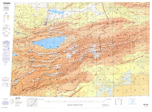
中国—吉尔吉斯斯坦边界


中国—吉尔吉斯斯坦边界长1,063 km(661 mi)[1] ,从与哈萨克斯坦的三角点开始,沿着大致西南的线穿过天山山脉的各个山脊和山峰,一直延伸到与塔吉克斯坦的三角点。[2]边界(从北到南/从东到西)兩邊分別為吉尔吉斯斯坦的伊塞克湖州、纳伦州和奥什州以及中国新疆维吾尔自治区的阿克苏地区和克孜勒苏柯尔克孜自治州。
历史
[编辑]
边界的起源可以追溯到19世纪中叶,当时俄罗斯帝国扩展到中亚并能够建立对斋桑泊地区的控制。1860年的北京条约划定了俄罗斯帝国与清朝的边界,与今天的中国—哈萨克/吉尔吉斯/塔吉克边界没有太大区别。[3][4]根据中俄勘分西北界约记(1864年)和《乌里雅苏台条约》(1870年)划定的实际边界线,将斋桑泊留在俄罗斯一侧。[5][6][4]清帝国在伊犁盆地的军事行动瓦解了同治陕甘回乱。在平定回乱,和左宗棠收复新疆后,伊犁条约(1881年)和一系列后来的协议,俄罗斯和清朝在伊犁河流域的边界进一步小幅调整有利于俄罗斯。[4]1915 年签署了更精确地划定伊犁河河谷和阿拉套山(准噶尔阿拉套)地区边界的协议。[4]
边境的最南端(即现代中国—塔吉克斯坦边界的南半部)仍未划定界限,部分原因是英国和俄罗斯在中亚争夺主导地位的持续竞争被称为大博弈;最终,两国同意阿富汗仍将是他们之间的独立缓冲国,阿富汗的瓦罕走廊于1895年建立。[4]中国不是这些协议的缔约方,因此中俄边界的最南端仍未确定。[4]
吉尔吉斯斯坦1991年独立后,继承了中苏边境的一部分。中华人民共和国和吉尔吉斯共和国两国于1996年划定边界。[7]以Azimbek Beknazarov为首的吉尔吉斯反对派分子反对《中华人民共和国和吉尔吉斯共和国关于中吉国界的协定》的边界条约,阻碍了正式划界,这是反对当时总统阿斯卡爾·阿卡耶夫的更广泛运动的一部分,最终导致郁金香革命。边界协议于2009年敲定,中国放弃了汗腾格里峰的一部分,而吉尔吉斯斯坦则割让了位于伊塞克湖地区南部的Uzengi-Kush山区。[8]
过境
[编辑]历史上,沿天山山脉向东的别迭里山口也曾被使用过。
历史地图
[编辑]20世纪中后期,中国—吉尔吉斯苏维埃社会主义共和国边界从北到南(西到东)的历史地图,取自于世界国际地图和操作导航图:
-
near 阿拉木图
-
near 阿克苏市
-
near 哈萨克苏维埃社会主义共和国 (今日的哈萨克斯坦)
-
near 塔吉克苏维埃社会主义共和国 (今日的塔吉克斯坦)
参见
[编辑]- 吉尔吉斯斯坦地理极点
注释
[编辑]- ^ From map: "DELINEATION OF INTERNATIONAL BOUNDARIES MUST NOT BE CONSIDERED AUTHORITATIVE"
参考
[编辑]- ^ FIELD LISTING :: LAND BOUNDARIES. The World Factbook. [1 February 2020].
China total: 22,457 km border countries (15): {...}Kyrgyzstan 1063 km,{...}Kyrgyzstan total: 4,573 km border countries (4): China 1063 km,{...
} - ^ CIA World Factbook - Kyrgyzstan, 23 September 2018 [2022-03-16], (原始内容存档于2021-06-22)
- ^ Articles 2 and 3 in the Russian text of the treaty
- ^ 4.0 4.1 4.2 4.3 4.4 4.5 International Boundary Study No. 64 – China-USSR Boundary (PDF), 13 February 1978 [23 September 2018], (原始内容 (PDF)存档于2014-08-17)
- ^ (See the map)
- ^ The Lost Frontier: the treaty maps that changed Qing's northwestern boundaries. [2022-03-16]. (原始内容存档于2015-03-13).
- ^
 中华人民共和国和吉尔吉斯共和国关于中吉国界的协定. 维基文库. 1996-07-04 (中文).
- ^ Kyrgyzstan, China end common border demarcation, 14 July 2009 [2022-03-16], (原始内容存档于2018-09-23)
- ^ 9.0 9.1 Caravanistan - Kyrgyzstan border crossings, [23 September 2018], (原始内容存档于2021-08-27) 引用错误:带有name属性“auto1”的
<ref>标签用不同内容定义了多次
Text is available under the CC BY-SA 4.0 license; additional terms may apply.
Images, videos and audio are available under their respective licenses.


![Map of the border (near 喀什市) including the tripoint with Tajikistan (世界国际地图(英语:International Map of the World),陆军地图服务部(英语:Army Map Service), 1966)[a]](https://upload.wikimedia.org/wikipedia/commons/thumb/a/ae/Txu-oclc-6654394-nj-43-5th-ed.jpg/335px-Txu-oclc-6654394-nj-43-5th-ed.jpg)


