Geosat
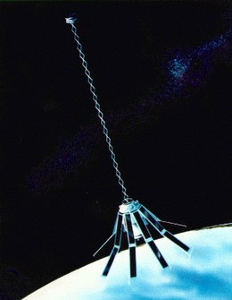
 艺术家描绘的Geosat想象图 | |
| 任务类型 | 地球观测 |
|---|---|
| 运营方 | 美国海军 |
| 国际卫星标识符 | 1985-021A |
| 卫星目录序号 | 15595 |
| 任务时长 | 5 年 |
| 圈数 | 50565 |
| 航天器属性 | |
| 制造方 | JHU/APL |
| 发射质量 | 635 kg[1] |
| 任务开始 | |
| 发射日期 | 1985-03-13 02:00:00 UTC |
| 运载火箭 | 阿特拉斯E/F |
| 发射场 | 范登堡 SLC-3W |
| 任务结束 | |
| 停用日期 | 1990-01-31 |
| 轨道参数 | |
| 参照系 | 地球 |
| 轨域 | LEO |
| 半长轴 | 7146.2 km |
| 离心率 | 0.00398 |
| 近地点 | 757.00 km |
| 远地点 | 814.00 km |
| 倾角 | 108.100° |
| 周期 | 100.6 分 |
| 历元 | 1985-03-12 00:00:00 UTC[2] |
Geosat | |
Geosat(英语:GEOdetic SATellite),亦称大地测量卫星,是美国海军在1985年至1990年间运营的卫星测高任务[3],主要用于军事、大地测量学和海洋学方面的研究,具体目标包括为海军提供全球的格网测高数据、研究海洋锋面、漩涡、风浪、冰川地形及海面地形等[4]。Geosat在当地时间1985年3月12日从美国西海岸的范登堡空军基地发射升空,先后执行了为其18个月的大地测量任务和为期三年的精密重复任务。后因技术故障,Geosat被迫于1990年1月提前终止所有任务。[5]
Geosat是20世纪80年代唯一运行的卫星测高任务,提供了世界上首个覆盖全球的、长期的高精度测高数据集,在物理海洋学、大地测量学、地球物理学和冰川学等研究中发挥了重要作用。[5][6]Geosat卫星的成功运行标志着卫星测高技术进入了成熟阶段。[7][8]:195
运营管理
Geosat最初是由美国海军的海军研究办公室管理,后管理权转交至海军电子战系统司令部(现称海军信息战系统司令部)。约翰·霍普金斯大学应用物理实验室(JHU/APL)设计和制造了用于Geosat任务的航天器及其有效载荷,并负责任务的具体操作。此外,JHU/APL、海军的水面武器中心及海洋研究与发展活动,以及美国国家海洋和大气管理局共同负责数据接收、整理、加工及存档和发布的服务。[9]
任务类型
大地测量任务
大地测量任务(英语:Geodetic Mission,缩写:GM)是Geosat的首要任务,其具体内容是提供密集的、全球范围的测高数据格网,以提高当时地球重力场模型的精度。[10]Geosat载有一台雷达高度计,使其能以约5厘米的精度量测卫星至海面的相对距离。[7]在GM任务中,Geosat运行在轨道倾角约108°、远地点高度814千米、近地点高度757千米、周期为100.6分钟的太阳同步极地轨道上。[11]为了获取全球范围的格网数据,这些轨道在地球表面上的投影并不相互重叠,而是存在漂移。具体地,Geosat在执行GM任务期间的地面轨迹重复周期为23.07天,每一重复周期内绕地运行330圈,平均邻轨距离为4千米。[12]
GM任务自1985年3月11日开始,于1986年9月30日结束[3],期间经过的地面轨迹长达2亿千米,共收集了约2.7亿个海面测高数据[10]。
精密重复任务
在完成GM任务后,Geosat于1986年9月30日进入了与先前发射的Seasat相同的运行轨道,并在1986年11月8日至1990年1月间执行精密重复任务(英语:Exact Repeat Mission,缩写:ERM)。[3]在进入ERM任务时,Geosat调整了轨道的偏心率和升交点等轨道参数,进入了与先前轨道相同倾角、但是更圆的近极地圆轨道上,运行的绕地周期为101分钟、重复周期为17.05天,每一重复周期绕地运行244圈。[11]利用卫星自身的推力机动,卫星的星下点轨迹和预期轨迹的偏差能维持在1千米内。精密重复的轨道使得Geosat能在其地面轨迹上获得高质量的重复监测数据,从而精确地对海洋的锋面、漩涡等中、小尺度结构进行量测。[6][10]
后续任务
Geosat的后续任务是后续大地测量卫星(英语:Geosat Follow On,缩写:GFO),该卫星搭载有水蒸气辐射计与雷达高度计,于1998年2月10日搭载金牛座运载火箭自范登堡空军基地发射[13],运行于与Geosat完全相同的轨道上。此外,GFO还配备了用于定轨的GPS接收机(虽然从未在运营中使用过)、多普勒接收机与激光回射器。[14]GFO任务原定于2008年12月31日结束,但航天器的状态在2008年9月末突然恶化,控制人员将受到系统故障影响的GFO降低到一个处置轨道上,并在2008年11月25日将GFO的任务终止。[15]
美国海军还曾计划于2014年发射名为GFO-2的后续任务,该卫星将搭载双波段高度计,而非先前任务中的单波段高度计。[16] 但在2010年6月30日,美国海军宣布取消了GFO-2任务。 [17]
参考文献
- ^ Satellite: GEOSat. WMO OSCAR. [2020-04-22]. (原始内容存档于2016-04-16) (英语).
- ^ NASA - NSSDCA - Spacecraft - Telemetry Details. nssdc.gsfc.nasa.gov. [2020-04-22]. (原始内容存档于2020-05-03).
- ^ 3.0 3.1 3.2 GEOSAT - eoPortal Directory - Satellite Missions. directory.eoportal.org. [2020-04-20]. (原始内容存档于2020-10-18) (美国英语).
- ^ US Department of Commerce, NOAA National Centers for Environmental Information. Geosat Introduction. www.nodc.noaa.gov. [2020-04-20]. (原始内容存档于2020-10-17) (英语).
- ^ 5.0 5.1 Lillibridge, John; Smith, Walter; Sandwell, David; Scharroo, Remko; Lemoine, François; Zelensky, Nikita. 20 Years of Improvements to GEOSAT Altimetry: 75. 2006-07-01 (英语).
- ^ 6.0 6.1 Douglas, Bruce C.; Cheney, Robert E. Geosat: Beginning a new era in satellite oceanography. Journal of Geophysical Research: Oceans. 1990, 95 (C3): 2833–2836 [2020-04-20]. ISSN 2156-2202. doi:10.1029/JC095iC03p02833. (原始内容存档于2020-05-03) (英语).
- ^ 7.0 7.1 Geosat | Science Mission Directorate. science.nasa.gov. [2020-04-20]. (原始内容存档于2020-10-22).
- ^ 李征航; 魏二虎; 王正涛; 彭碧波. 空间大地测量学. 武汉大学出版社. ISBN 978-7-30-707574-0.
- ^ Geosat. GlobalSecurity.org. [2020-04-21]. (原始内容存档于2017-04-21) (英语).
- ^ 10.0 10.1 10.2 R. McCONATHY, DONALD; C. KILGUS, CHARLES. THE NAVY GEOSAT MISSION: AN OVERVIEW (PDF). [2020-04-20]. (原始内容存档 (PDF)于2019-08-16).
- ^ 11.0 11.1 Shapiro, Bruce. The Geosat orbit adjust (PDF). JAnSc. 1988-12, 36: 407–424 [2020-04-20]. ISSN 0021-9142. (原始内容存档 (PDF)于2016-05-08) (英语).
- ^ Geosat Chapter 1. web.archive.org. 2010-05-25 [2020-04-20]. 原始内容存档于2010-05-25.
- ^ GFO - NSSDC ID: 1998-007A. NASA NSSDC. [2020-04-20]. (原始内容存档于2020-05-03).
- ^ The GFO Spacecraft and Mission Design. Computer Sciences Corporation. [2020-04-20]. (原始内容存档于2014-04-13).
- ^ Monheim, Angela L.; Pritikin, Lance; Mayer, Greg; San Juan, Gerardo; Palmer, Ryan; Miller, Kevin; Mitchell, Scott; Weiss, Michael; et al. GFO: Disposal of a Power-Challenged Satellite with an Attitude (Control) Problem (PDF). AIAA SPACE 2009 Conference & Exposition. Pasadena, California. 2009 [2020-04-20]. (原始内容存档于2011-07-08).
- ^ Ball Aerospace Wins Contract for Navy's GFO-2 Altimetry Satellite (新闻稿). Ball Aerospace. April 19, 2010 [2020-04-20]. (原始内容存档于2010-04-26).
- ^ Cancelled Department of the Navy Security Classification Guide Report (PDF). 16 March 2016. (原始内容存档 (PDF)于2015-09-24).
外部链接
| |||||||||||||||||||||||||||||||||||||||||||||||||||
| |||||||||||||||||||||||||||||||||||||||||||||||||||||||||||||||||||||||||||||||||||||||||||||||||||||||||||||||||||||||||||||||||||
Text is available under the CC BY-SA 4.0 license; additional terms may apply.
Images, videos and audio are available under their respective licenses.
