马鞍山郊野公园


Map
马鞍山郊野公园(英语:Ma On Shan Country Park)划定于1979年4月27日,是香港的一个郊野公园,位于新界沙田马鞍山,占地达2,880公顷,分为两部分,除马鞍山部分外,白沙湾及牛尾海之间的白沙湾半岛也属公园范围。
马鞍山郊野公园范围南至飞鹅山(彩云邨扎山道),西接狮子山郊野公园,东接西贡西郊野公园,有大老山、马鞍山、观音山、水牛山、大金钟、牛押山等山峰。此外,公园范围内有目前全港第二长的行车隧道大老山隧道,而大老山隧道成为九龙东和香港岛直达新界东之主要行车隧道。
马鞍山郊野公园内有马鞍山郊游径、马鞍山家乐径、企岭下树木研习径、卫奕信径(第四段,由井栏树至沙田坳)、麦理浩径(第四段,由水浪窝至基维尔营地)、昂平营地(跟大屿山的昂坪无关)、马鞍山特别地区,并设有多个烧烤场地,分别位于水浪窝、企岭下、泥涌及马鞍山村。
地形
-
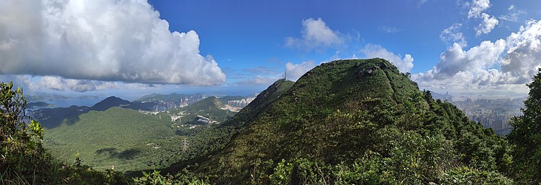 马鞍山郊野公园有多座高山。图为象山及飞鹅山。

石屋厕所
- 马鞍山烧烤场
- 泥涌烧烤场
- 扎山道晨运公园
外部链接
- 渔农自然护理署 马鞍山 (页面存档备份,存于互联网档案馆)
 OpenStreetMap上有关555476776 马鞍山郊野公园的地理信息
| ||||||||||||||||||||||||||||||||
Text is available under the CC BY-SA 4.0 license; additional terms may apply.
Images, videos and audio are available under their respective licenses.
Cover photo is available under {{::mainImage.info.license.name || 'Unknown'}} license.
Cover photo is available under {{::mainImage.info.license.name || 'Unknown'}} license.
Credit:
(see original file).
