阿雷西费
| 阿雷西费 Arrecife | |||
|---|---|---|---|
| 市镇 | |||
| |||
 在兰萨罗特岛的位置 | |||
 阿雷西费 在西班牙加那利群岛的位置 | |||
| 坐标:28°57′45″N 13°33′02″W / 28.9625°N 13.550555555556°W | |||
| 国家 | |||
| 自治区 | 加那利群岛 | ||
| 省份 | 拉斯帕尔马斯省 | ||
| 岛屿 | 兰萨罗特岛 | ||
| 面积[1] | |||
| • 总计 | 22.72 平方公里(8.77 平方英里) | ||
| 人口(2018)[2] | |||
| • 总计 | 61,351人 | ||
| • 密度 | 2,700人/平方公里(6,994人/平方英里) | ||
| 时区 | WET(UTC+0) | ||
| • 夏时制 | WEST(UTC+1) | ||
| 邮编 | 35500 | ||
| 网站 | www | ||


阿雷西费(西班牙语:Arrecife),是西班牙加那利群岛拉斯帕尔马斯省的一个市镇。自1852年起成为兰萨罗特岛的首府。总面积约23平方公里,总人口61351人(2018年),人口密度2700人/平方公里。
人口
[编辑]| 年份 | 人口 |
|---|---|
| 2001 | 45,549 |
| 2002 | 48,253 |
| 2003 | 50,785 |
| 2006 | 55,203 |
| 2009 | 59,127 |
| 2013 | 55,673 |
| 2014 | 56,880 |
| 数据来源:ISTAC[3] | |
气候
[编辑]兰萨罗特岛的气候据柯本气候分类法为沙漠气候[4]。极少的降水量集中在冬季的几个月份里。
| 兰萨罗特机场(1981-2010) | |||||||||||||
|---|---|---|---|---|---|---|---|---|---|---|---|---|---|
| 月份 | 1月 | 2月 | 3月 | 4月 | 5月 | 6月 | 7月 | 8月 | 9月 | 10月 | 11月 | 12月 | 全年 |
| 历史最高温 °C(°F) | 27.9 (82.2) |
29.0 (84.2) |
32.7 (90.9) |
36.3 (97.3) |
42.6 (108.7) |
40.7 (105.3) |
42.9 (109.2) |
43.6 (110.5) |
40.5 (104.9) |
37.1 (98.8) |
34.2 (93.6) |
27.5 (81.5) |
43.6 (110.5) |
| 平均高温 °C(°F) | 20.7 (69.3) |
21.3 (70.3) |
22.9 (73.2) |
23.5 (74.3) |
24.6 (76.3) |
26.3 (79.3) |
28.2 (82.8) |
29.1 (84.4) |
28.6 (83.5) |
26.7 (80.1) |
24.2 (75.6) |
21.8 (71.2) |
24.8 (76.6) |
| 日均气温 °C(°F) | 17.4 (63.3) |
17.9 (64.2) |
19.0 (66.2) |
19.6 (67.3) |
20.8 (69.4) |
22.6 (72.7) |
24.3 (75.7) |
25.2 (77.4) |
24.7 (76.5) |
23.0 (73.4) |
20.7 (69.3) |
18.6 (65.5) |
21.1 (70.0) |
| 平均低温 °C(°F) | 14.0 (57.2) |
14.3 (57.7) |
15.0 (59.0) |
15.7 (60.3) |
16.8 (62.2) |
18.8 (65.8) |
20.4 (68.7) |
21.2 (70.2) |
20.8 (69.4) |
19.4 (66.9) |
17.2 (63.0) |
15.4 (59.7) |
17.4 (63.3) |
| 历史最低温 °C(°F) | 8.0 (46.4) |
9.0 (48.2) |
8.3 (46.9) |
9.5 (49.1) |
11.5 (52.7) |
12.4 (54.3) |
15.4 (59.7) |
16.6 (61.9) |
15.5 (59.9) |
12.0 (53.6) |
10.9 (51.6) |
9.0 (48.2) |
8.0 (46.4) |
| 平均降雨量 mm(吋) | 16.5 (0.65) |
18.2 (0.72) |
12.5 (0.49) |
5.2 (0.20) |
1.5 (0.06) |
0.1 (0.00) |
0.0 (0.0) |
0.5 (0.02) |
2.2 (0.09) |
9.9 (0.39) |
14.7 (0.58) |
29.3 (1.15) |
110.6 (4.35) |
| 平均降雨天数(≥ 1.0 mm) | 3 | 3 | 2 | 1 | 0 | 0 | 0 | 0 | 0 | 2 | 3 | 4 | 18 |
| 月均日照时数 | 203 | 201 | 241 | 255 | 297 | 292 | 308 | 295 | 248 | 235 | 207 | 196 | 2,978 |
| 数据来源:Agencia Estatal de Meteorología[5] | |||||||||||||
图集
[编辑]-
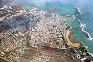 阿雷西费鸟瞰图
 -
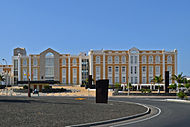 兰萨罗特岛政府大楼
 -
 阿雷西费市政厅
 -
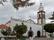 教堂
教堂 -
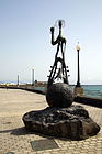 阿雷西费海边雕塑
 -
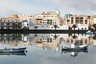 阿雷西费市容
 -
 阿雷西费港口


参考文献
[编辑]- ^ ISTAC: Estadística del Territorio. Gobierno de Canarias. [2015-12-28]. (原始内容存档于2015-11-13) (西班牙语).
08 Superficie, perímetro, longitud de costa, altitud y distancia a la capital por municipios.
- ^ 2018年西班牙市政户籍登记. 西班牙国家统计局.
- ^ Estadística de la Evolución Histórica de la Población / Series anuales. Municipios por islas de Canarias. 1768-2014. Gobierno de Canarias. [2015-12-28]. (原始内容存档于2015-11-13) (西班牙语).
01 Población. Municipios por islas y años.
- ^ ARRECIFE, SPAIN. Weatherbase. [2017-12-11]. (原始内容存档于2019-11-29) (英语).
- ^ Guía resumida del clima en España (1981-2010). AEMET. (原始内容存档于2012-11-18) (西班牙语).
外部链接
[编辑]
| |||||||||||||||||||||
Text is available under the CC BY-SA 4.0 license; additional terms may apply.
Images, videos and audio are available under their respective licenses.
Cover photo is available under {{::mainImage.info.license.name || 'Unknown'}} license.
Cover photo is available under {{::mainImage.info.license.name || 'Unknown'}} license.
Credit:
(see original file).
