For faster navigation, this Iframe is preloading the Wikiwand page for 阿勒代斯山脉.

阿勒代斯山脉

阿勒代斯山脉
Allardyce Range
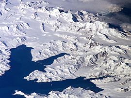
Central South Georgia: Cumberland Bay; Thatcher Peninsula with King Edward Cove (Grytviken); Allardyce Range with the summit Mount Paget (NASA imagery).
最高点
海拔2,935米(9,629英尺) [1]
坐标54°25′S 36°32′W / 54.417°S 36.533°W / -54.417; -36.533
地理
位置南乔治亚岛

阿勒代斯山脉(英语:Allardyce Range)是南乔治亚岛与南桑威奇群岛山脉,最高点海拔高度2,935米,山体由沉积岩组成,该山脉在1915年以福克兰群岛总督命名。

参考资料

{{bottomLinkPreText}} {{bottomLinkText}}
阿勒代斯山脉
Listen to this article

This browser is not supported by Wikiwand :(
Wikiwand requires a browser with modern capabilities in order to provide you with the best reading experience.
Please download and use one of the following browsers:

This article was just edited, click to reload
This article has been deleted on Wikipedia (Why?)

Back to homepage

Please click Add in the dialog above
Please click Allow in the top-left corner,
then click Install Now in the dialog
Please click Open in the download dialog,
then click Install
Please click the "Downloads" icon in the Safari toolbar, open the first download in the list,
then click Install
{{::$root.activation.text}}

Install Wikiwand

Install on Chrome Install on Firefox
Don't forget to rate us

Tell your friends about Wikiwand!

Gmail Facebook Twitter Link

Enjoying Wikiwand?

Tell your friends and spread the love:
Share on Gmail Share on Facebook Share on Twitter Share on Buffer

Our magic isn't perfect

You can help our automatic cover photo selection by reporting an unsuitable photo.

This photo is visually disturbing This photo is not a good choice

Thank you for helping!


Your input will affect cover photo selection, along with input from other users.

X

Get ready for Wikiwand 2.0 🎉! the new version arrives on September 1st! Don't want to wait?