诺顿 (堪萨斯州)
| 诺顿 Norton | |
|---|---|
| 城市 | |
 诺顿县法院(2010年) | |
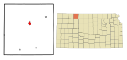
 诺顿于诺顿县及堪萨斯州的地理位置 | |
 诺顿县交通地图(图例) | |
| 坐标:39°50′00″N 99°53′27″W / 39.8333°N 99.8908°W | |
| 国家 | 美国 |
| 州 | 堪萨斯州 |
| 县 | 诺顿县 |
| 面积[1] | |
| • 总计 | 5.00 平方公里(1.93 平方英里) |
| • 陆地 | 5.00 平方公里(1.93 平方英里) |
| • 水域 | 0 平方公里(0 平方英里) |
| 海拔 | 705 米(2,313 英尺) |
| 人口(2010)[2] | |
| • 总计 | 2,928人 |
| • 估计(2012[3]) | 2,871 |
| • 密度 | 586人/平方公里(1,517人/平方英里) |
| 时区 | CST(UTC-6) |
| • 夏时制 | CDT(UTC-5) |
| 邮区编号 | 67654 |
| 电话区号 | 785 |
| FIPS代码 | 20-51500 [4] |
| GNIS编号 | 0471901 [5] |
| 网站 | 官方网站 |
诺顿(Norton)为美国堪萨斯州诺顿县的一座城市,也是诺顿县的县治所在地[6]。根据2010年美国人口普查,此城市人口有2,928人[7]。
历史
诺顿于1872年设立[8]。城市名与所属县份一样皆以联邦上尉奥尔洛夫·诺顿(Orloff Norton)来命名[9]。
首幢以原木筑成的饭店于1873年建成[10]。
地理
诺顿坐落在北纬39度50分0秒、西经99度53分27秒(亦可表示为39.833338, -99.890899)处[11]。根据美国人口调查局的资料,此城市总面积为1.93平方英里(5.00平方千米),全境皆为陆地[1]。此城市坐落于诺顿县境内的普雷里多格溪北边。在美国农垦局于1963年建造基思西贝利厄斯湖之前,诺顿经常饱受水患,因此在此城市西南方2.5英里(4.0千米)处兴建大坝方得解决水患问题[12]。内布拉斯加州州界位于此城市北方11英里(18千米)处。
气候
诺顿坐落于副热带湿润气候和半干旱气候两气候区的边界上。此地区1月平均低温15°F(-9.4°C),7月平均高温94°F(34.4°C),年温差较大。此地区全年平均降水量有21.1英寸(540毫米),降水量相对较低,而全年平均降雪量达25.1英寸(640毫米)。
| 堪萨斯州诺顿 | |||||||||||||
|---|---|---|---|---|---|---|---|---|---|---|---|---|---|
| 月份 | 1月 | 2月 | 3月 | 4月 | 5月 | 6月 | 7月 | 8月 | 9月 | 10月 | 11月 | 12月 | 全年 |
| 历史最高温 °F(°C) | 81 (27) |
81 (27) |
93 (34) |
100 (38) |
105 (41) |
114 (46) |
117 (47) |
115 (46) |
112 (44) |
101 (38) |
86 (30) |
83 (28) |
117 (47) |
| 平均高温 °F(°C) | 42 (6) |
47 (8) |
55 (13) |
67 (19) |
76 (24) |
87 (31) |
94 (34) |
93 (34) |
86 (30) |
72 (22) |
56 (13) |
45 (7) |
68 (20) |
| 平均低温 °F(°C) | 15 (−9) |
19 (−7) |
26 (−3) |
38 (3) |
49 (9) |
60 (16) |
65 (18) |
64 (18) |
54 (12) |
41 (5) |
27 (−3) |
19 (−7) |
40 (4) |
| 历史最低温 °F(°C) | −24 (−31) |
−23 (−31) |
−20 (−29) |
4 (−16) |
26 (−3) |
37 (3) |
44 (7) |
39 (4) |
19 (−7) |
8 (−13) |
−11 (−24) |
−19 (−28) |
−24 (−31) |
| 平均降水量 吋(mm) | 0.4 (10) |
0.7 (18) |
1.2 (30) |
2.1 (53) |
3 (76) |
3.7 (94) |
2.7 (69) |
2.7 (69) |
1.0 (25) |
1.4 (36) |
0.8 (20) |
0.6 (15) |
21.1 (540) |
| 平均降雪量 吋(cm) | 4 (10) |
5.5 (14) |
7.2 (18) |
1.8 (4.6) |
0.1 (0.25) |
0 (0) |
0 (0) |
0 (0) |
0 (0) |
0.2 (0.51) |
2.6 (6.6) |
3.7 (9.4) |
25.1 (64) |
| 平均降雨天数 | 1.5 | 2.2 | 3.4 | 4.9 | 6.1 | 6.5 | 5.3 | 5.2 | 3.5 | 2.7 | 2 | 1.8 | 45.1 |
| 数据来源:Weatherbase [13] NOAA[14] | |||||||||||||
人口统计
| 历史人口数 | |||
|---|---|---|---|
| 调查年 | 人口 | %± | |
| 1880年 | 634 | — | |
| 1890年 | 1,074 | 69.4% | |
| 1900年 | 1,202 | 11.9% | |
| 1910年 | 1,787 | 48.7% | |
| 1920年 | 2,186 | 22.3% | |
| 1930年 | 2,767 | 26.6% | |
| 1940年 | 2,762 | −0.2% | |
| 1950年 | 3,060 | 10.8% | |
| 1960年 | 3,345 | 9.3% | |
| 1970年 | 3,627 | 8.4% | |
| 1980年 | 3,400 | −6.3% | |
| 1990年 | 3,017 | −11.3% | |
| 2000年 | 3,012 | −0.2% | |
| 2010年 | 2,928 | −2.8% | |
| 2014年估计 | 2,846 | [15] | −2.8% |
| U.S. Decennial Census | |||
2010年普查
据2010年人口普查,此城市人口有2,928人,户数1,290户,763个家庭。人口密度为585.8人/每平方公里(1,517.1人/每平方英里)。此城市有1,465栋住宅,平均每平方公里有293.1栋住宅。此城市居民之种族中,白人占96.8%,非裔美国人占0.2%,美洲原住民占0.1%,亚裔美国人占0.4%,其他种族占0.5%,混血种族则占1.9%。而西班牙裔或拉丁裔美国人占此城市人口的3.3%[2]。
此城市之户籍数计有1,290户。其中拥有18岁以下孩童的住户占26.3%;已婚夫妇且同居的住户占46.5%,住户为女性单亲者占9.3%;住户为男性单亲者占3.3%;住户并非一个家庭的占40.9%。住户为独自一人居住的占全户之36.1%,其中有18.3%为65岁或以上之独居老人。每户住户平均成员人数为2.20人,每个家庭平均成员人数则是2.86人[2]。
此城市居民之年龄中位数为44.8岁。以年龄层分类,年龄低于18岁者占23.2%;年龄介在18岁至24岁之间者占6.4%;年龄介在25岁至44岁之间者占20.6%;年龄介在45岁至64岁之间者占27.8%;年龄高于65岁者占22%。男性占全市人口之46.6%,女性则占全市人口之53.4%[2]。
2000年普查
据2000年人口普查,此城市人口有3,012人,户数1,331户,814个家庭。人口密度为605.7人/每平方公里(1,566.5人/每平方英里)。此城市有1,517栋住宅,平均每平方公里有305.1栋住宅。此城市居民之种族中,白人占97.91%,非裔美国人占0.03%,美洲原住民占0.40%,亚裔美国人占0.33%,0.03%为太平洋岛民,其他种族占0.63%,混血种族则占0.66%。而西班牙裔或拉丁裔美国人占此城市人口的2.03%[4]。
此城市之户籍数计有1,331户,其中拥有18岁以下孩童的住户占27.7%;已婚夫妇且同居的住户占50.5%,住户为女性单亲者占8.5%;住户并非一个家庭的占38.8%。住户为独自一人居住的占全户之36.1%,其中有20.7%为65岁或以上之独居老人。每户住户平均成员人数为2.19人,每个家庭平均成员人数则是2.86人[4]。
以年龄层分类,年龄低于18岁者占24.5%;年龄介在18岁至24岁之间者占5.3%;年龄介在25岁至44岁之间者占23.5%;年龄介在45岁至64岁之间者占22.1%;年龄高于65岁者占24.6%。此城市居民之年龄中位数为43岁。性别比方面,每100名女性所对应的男性数为91.5名,如只计算18岁或以上的居民,则是每100名女性所对应的男性数为82.9名[4]。
此城市每户平均收入为30,339美元,每个家庭平均收入为36,179美元。男性平均收入25,943美元;女性平均收入20,559美元。此城市人均收入为16,438美元。此城市约有5.5%的家庭以及9.5%的居民低于贫穷门槛,其中18岁以下者占10.4%,65岁以上者占6.5%[4]。
知名人物
- 尼克·艾伦,棒球选手
- 凯瑟琳·西贝利厄斯,第21任美国卫生及公共服务部部长[16],前堪萨斯州州长
- 基思·西贝利厄斯,美国前众议员
- 基思·盖瑞·西贝利厄斯,美国地方法官,基思·西贝利厄斯之子,凯瑟琳·西贝利厄斯的丈夫
参见
- 基思西贝利厄斯湖
参考资料
- ^ 1.0 1.1 US Gazetteer files 2010. 美国人口调查局. [2012-07-06]. (原始内容存档于2012-07-14).
- ^ 2.0 2.1 2.2 2.3 American FactFinder. 美国人口调查局. [2012-07-06]. (原始内容存档于2012-02-17).
- ^ Population Estimates. 美国人口调查局. [2013-05-29]. (原始内容存档于2013-06-17).
- ^ 4.0 4.1 4.2 4.3 4.4 American FactFinder. 美国人口调查局. [2008-01-31]. (原始内容存档于2013-09-11).
- ^ US Board on Geographic Names. 美国地质调查局. 2007-10-25 [2008-01-31]. (原始内容存档于2012-02-26).
- ^ Find a County. National Association of Counties. [2011-06-07]. (原始内容存档于2012-07-12).
- ^ 2010 City Population and Housing Occupancy Status. U.S. Census Bureau. [2011-03-27]. (原始内容存档于2011-07-21).
- ^ Kansas State Historical Society. Biennial Report of the Board of Directors of the Kansas State Historical Society. Kansas State Printing Plant. 1916: 253 [2016-07-08]. (原始内容存档于2017-11-06).
- ^ Profile for Norton, Kansas. ePodunk. [2014-06-21]. (原始内容存档于2014-07-15).
- ^ Blackmar, Frank Wilson. Kansas: A Cyclopedia of State History, Volume 2. Standard Publishing Company. 1912: 374 [2016-07-08]. (原始内容存档于2014-10-30).
- ^ US Gazetteer files: 2010, 2000, and 1990. 美国人口调查局. 2011-02-12 [2011-04-23]. (原始内容存档于2006-07-20).
- ^ Project Details - Almena Unit. United States Bureau of Reclamation. [2010-11-02]. (原始内容存档于2015-09-05).
- ^ Historical Weather for Norton, KS. Weatherbase. [2009-09-04]. (原始内容存档于2012-01-29).
- ^ Norton Climate Records. NOAA. [2009-09-04]. (原始内容存档于2009-08-16).
- ^ Annual Estimates of the Resident Population for Incorporated Places: April 1, 2010 to July 1, 2014. [2015-06-04]. (原始内容存档于2015-05-23).
- ^ Goldstein, David; Klepper, David. Sebelius sworn in to Cabinet, Parkinson becomes Kansas governor. The Kansas City Star. 2009-04-28 [2009-04-29]. (原始内容存档于2009-04-30).
外部链接
- 城市
- 学校
- 地图
延伸阅读
- History of the State of Kansas; William G. Cutler; A.T. Andreas Publisher; 1883. (Online HTML eBook)(页面存档备份,存于互联网档案馆)
- Kansas : A Cyclopedia of State History, Embracing Events, Institutions, Industries, Counties, Cities, Towns, Prominent Persons, Etc; 3 Volumes; Frank W. Blackmar; Standard Publishing Co; 944 / 955 / 824 pages; 1912. (Volume1 - Download 54MB PDF eBook),(Volume2 - Download 53MB PDF eBook), (Volume3 - Download 33MB PDF eBook)
| |||||||||||||||||
Text is available under the CC BY-SA 4.0 license; additional terms may apply.
Images, videos and audio are available under their respective licenses.
