华谢基县
| 华谢基县 Washakie County | |
|---|---|
| 县 | |
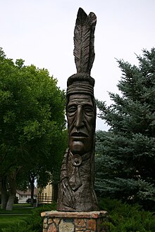
 位于沃兰的印第安图腾 | |
 华谢基县于怀俄明州中的位置 | |
 怀俄明州于美国的位置 | |
| 坐标:43°55′N 107°41′W / 43.91°N 107.68°W | |
| 国家 | |
| 州 | |
| 设立日期 | 1911年2月21日(授权设立) 1913年(正式组建) |
| 语源 | 华谢基酋长 |
| 县治 | 沃兰 |
| 最大城市 | 沃兰 |
| 面积 | |
| • 总计 | 2,243 平方英里(6,000 平方公里) |
| • 陆地 | 2,239 平方英里(6,000 平方公里) |
| • 水域 | 4.2 平方英里(10 平方公里) 0.2%% |
| 人口(2020年) | |
| • 总计 | 7,685人 |
| • 估计(2019年) | 7,805 |
| 时区 | 山区时区(UTC−7) |
| • 夏时制 | 山区时区(UTC−6) |
| 包含的国会选区 | 单一国会选区 |
| 网站 | www |
华谢基县(英语:Washakie County)是位于美国怀俄明州中部的县。根据2020年美国人口普查结果显示,该县人口为7,685人。[1]该县的县治及最大城市皆为沃兰。[2]
历史
[编辑]该县于1911年2月21日获得成立授权,随后于1913年从比格霍恩县中分出得以正式成立。[3]该县原本打算被命名为汉诺威县,但为纪念美国的肖松尼人盟友华谢基酋长,该县最终被命名为华谢基县。[4]
地理
[编辑]根据美国普查局的数据显示,该县的总面积为2,243平方英里(5,810平方千米),其中陆地面积为2,239平方英里(5,800平方千米),水域面积为4.2平方英里(11平方千米),水域率为千分之二。[5]
毗邻县
[编辑]国家保护区
[编辑]- 大角国家森林(部分地区)
人口
[编辑]| 历史人口数 | |||
|---|---|---|---|
| 调查年 | 人口 | %± | |
| 1920年 | 3,106 | — | |
| 1930年 | 4,109 | 32.3% | |
| 1940年 | 5,858 | 42.6% | |
| 1950年 | 7,252 | 23.8% | |
| 1960年 | 8,883 | 22.5% | |
| 1970年 | 7,569 | −14.8% | |
| 1980年 | 9,496 | 25.5% | |
| 1990年 | 8,388 | −11.7% | |
| 2000年 | 8,289 | −1.2% | |
| 2010年 | 8,533 | 2.9% | |
| 2020年 | 7,685 | −9.9% | |
| 美国十年一次的人口普查[6] 1870–2000[7] 2010–2016[1] | |||
2000年人口普查
[编辑]根据2000年美国人口普查的结果显示,该县共有8,289位居民、3,278个住户和2,310个家庭,人口密度为4名居民每平方英里(1.5名居民每平方千米)。该县共有3,654个住房单位,其平均密度约为2每平方英里(0.77每平方千米)。该县人口的种族构成为90.22%白人,0.11%的非裔,0.55%的美洲原住民,0.74%的亚裔,6.21%的其他族裔以及2.17%的混血,其中拉丁裔占总人口数的11.47%。在该县所有居民中,27.1%是德裔,13.1%是英裔,9.9%是爱尔兰裔,6.2%的居民自认是美国人。[8]
在全县所有3,278个住户中,32.40%的住户有18岁以下子女并与之同住,59.90%的住户为已婚同居夫妇,7.30%的住户户主为没有丈夫的女性,29.50%的住户为非家庭,26.50%的住户由个人组成,11.90%的住户为65岁以上的独居者。每个住户的平均人数为2.47人,每个家庭的平均人数为3人。[8]
华谢基县18岁以下人口占27.20%,18-24岁人口占6.40%,25-44岁人口占25.20%,45-64岁人口占25.30%,65岁以上人口占15.90%。该县所有居民的年龄中位数为39岁。在所有年龄段的居民中,男女比例为99.40:100,若只考虑18岁以上居民,男女比例则为96.30:100。[8]
华谢基县所有住户的收入中位数为34,943美元,家庭的收入中位数为42,584美元,男性的收入中位数为31,633美元,而女性则只有21,028美元。该县的人均收入为17,780美元。华谢基县目前大约有10.00%的家庭和14.10%的个人处于贫困线以下,其中18岁以下人口占21.10%,65岁以上人口占12.20%。[8]
2010年人口普查
[编辑]根据2010年美国人口普查的结果显示,该县共有8,533位居民、3,492个住户和2,395个家庭[9],人口密度为3.8名居民每平方英里(1.5名居民每平方千米)。该县共有3,833个住房单位,其平均密度约为1.7每平方英里(0.66每平方千米)。[10]该县人口的种族构成为91.4%白人,1.1%的美洲原住民,0.6%的亚裔,0.3%的非裔,4.4%的其他族裔以及2.4%的混血,其中拉丁裔占总人口数的13.6%。在该县所有居民中,33.1%是德裔,17.6%是英裔,11.7%是爱尔兰裔,6.6%的居民自认是美国人,5.5%是挪威裔。[11]
在全县所有3,492个住户中,30.0%的住户有18岁以下子女并与之同住,56.4%的住户为已婚同居夫妇,7.9%的住户户主为没有丈夫的女性,31.4%的住户为非家庭,27.7%的住户由个人组成。每个住户的平均人数为2.40人,每个家庭的平均人数为2.93人。该县所有居民的年龄中位数为44岁。[9]
华谢基县所有住户的收入中位数为48,379美元,家庭的收入中位数为61,340美元,男性的收入中位数为45,579美元,而女性则只有30,107美元。该县的人均收入为28,557美元。华谢基县目前大约有1.7%的家庭和5.6%的个人处于贫困线以下,其中18岁以下人口占1.8%,65岁以上人口占9.9%。[12]
政府和基础设施
[编辑]和怀俄明州其他绝大部分县一样,华谢基县亦偏向共和党。自1936年富兰克林·罗斯福在全国范围内以压倒性的优势击败阿尔夫·兰登以来,民主党人再也没有赢得过该县。虽然在1964年总统选举中林登·约翰逊仅比巴里·戈德华特少18票,但在此之后的每一场选举中民主党得票数均未达到总票数的三分之一。
| 年份 | 共和党 | 民主党 | 第三党 | |||
|---|---|---|---|---|---|---|
| No. | % | No. | % | No. | % | |
| 2020年 | 3,245 | 80.88% | 651 | 16.23% | 116 | 2.89% |
| 2016年 | 2,911 | 76.32% | 532 | 13.95% | 371 | 9.73% |
| 2012年 | 3,014 | 76.42% | 794 | 20.13% | 136 | 3.45% |
| 2008年 | 2,956 | 72.29% | 1,042 | 25.48% | 91 | 2.23% |
| 2004年 | 3,200 | 77.78% | 855 | 20.78% | 59 | 1.43% |
| 2000年 | 3,138 | 77.46% | 806 | 19.90% | 107 | 2.64% |
| 1996年 | 2,250 | 56.73% | 1,205 | 30.38% | 511 | 12.88% |
| 1992年 | 1,720 | 43.19% | 1,118 | 28.08% | 1,144 | 28.73% |
| 1988年 | 2,538 | 67.36% | 1,197 | 31.77% | 33 | 0.88% |
| 1984年 | 3,245 | 76.30% | 970 | 22.81% | 38 | 0.89% |
| 1980年 | 2,634 | 67.59% | 945 | 24.25% | 318 | 8.16% |
| 1976年 | 2,361 | 66.68% | 1,168 | 32.99% | 12 | 0.34% |
| 1972年 | 2,604 | 75.92% | 825 | 24.05% | 1 | 0.03% |
| 1968年 | 2,038 | 64.01% | 948 | 29.77% | 198 | 6.22% |
| 1964年 | 1,713 | 50.26% | 1,695 | 49.74% | 0 | 0.00% |
| 1960年 | 2,254 | 62.70% | 1,341 | 37.30% | 0 | 0.00% |
| 1956年 | 2,265 | 69.61% | 989 | 30.39% | 0 | 0.00% |
| 1952年 | 2,148 | 70.82% | 880 | 29.01% | 5 | 0.16% |
| 1948年 | 1,074 | 55.79% | 851 | 44.21% | 0 | 0.00% |
| 1944年 | 1,130 | 59.26% | 777 | 40.74% | 0 | 0.00% |
| 1940年 | 1,080 | 53.12% | 942 | 46.34% | 11 | 0.54% |
| 1936年 | 810 | 41.26% | 1,109 | 56.50% | 44 | 2.24% |
| 1932年 | 711 | 40.61% | 1,009 | 57.62% | 31 | 1.77% |
| 1928年 | 966 | 70.72% | 392 | 28.70% | 8 | 0.59% |
| 1924年 | 724 | 60.13% | 209 | 17.36% | 271 | 22.51% |
| 1920年 | 609 | 64.31% | 333 | 35.16% | 5 | 0.53% |
| 1916年 | 344 | 42.05% | 455 | 55.62% | 19 | 2.32% |
| 1912年 | 258 | 38.22% | 221 | 32.74% | 196 | 29.04% |
由怀俄明州家庭服务部青少年服务组辖下的怀俄明州男子学校便位于华谢基县一处名为麦克纳特的非建制地区,该地区临近沃兰。[14]这所男子学校之前曾由怀俄明州慈善与改革委员会负责运营,直到该机构因1990年11月通过的州宪法修正案解散。[15]
参考来源
[编辑]- ^ 1.0 1.1 State & County QuickFacts. US Census Bureau. [2014-01-25]. (原始内容存档于2016-02-27).
- ^ Find a County. National Association of Counties. [2011-06-07]. (原始内容存档于2011-05-31).
- ^ Long, John H. (编). Wyoming: Individual County Chronologies. Wyoming Atlas of Historical County Boundaries. The Newberry Library. 2004 [2015-08-19]. (原始内容存档于2015-08-03).
- ^ Name of New County Changed. The Laramie Republican. 1911-01-25: 7 [2022-02-16] –通过Wyoming Newspapers.
- ^ 2010 Census Gazetteer Files. US Census Bureau. 2012-08-22 [2015-08-18]. (原始内容存档于2022-03-18).
- ^ US Decennial Census. US Census Bureau. [2015-08-18]. (原始内容存档于2015-04-26).
- ^ Historical Decennial Census Population for Wyoming Counties, Cities, and Towns. Wyoming Department of Administration & Information, Division of Economic Analysis. [2014-01-25]. (原始内容存档于2006-10-07).
- ^ 8.0 8.1 8.2 8.3 U.S. Census website. US Census Bureau. [2011-05-14]. (原始内容存档于1996-12-27).
- ^ 9.0 9.1 Profile of General Population and Housing Characteristics: 2010 Demographic Profile Data. US Census Bureau. [2016-01-12]. (原始内容存档于2020-02-13).
- ^ Population, Housing Units, Area, and Density: 2010 - County. US Census Bureau. [2016-01-12]. (原始内容存档于2020-02-13).
- ^ Selected Social Characteristics in the US – 2006-2010 American Community Survey 5-Year Estimates. US Census Bureau. [2016-01-12]. (原始内容存档于2020-02-13).
- ^ Selected Economic Characteristics – 2006-2010 American Community Survey 5-Year Estimates. US Census Bureau. [2016-01-12]. (原始内容存档于2020-02-13).
- ^ Leip, David. Atlas of US Presidential Elections. uselectionatlas.org. [2018-04-05]. (原始内容存档于2018-03-23).
- ^ Wyoming Boys School. usnews. [2023-01-29]. (原始内容存档于2023-01-29).
- ^ About the Department of Corrections. Wyoming Department of Corrections. [2022-10-09]. (原始内容存档于2008-12-04) (英语).
 |
帕克县 | 比格霍恩县 | 
| |
| 温泉县 | 约翰逊县 | |||
| ||||
| 弗里蒙特县 | 纳特罗纳县 |
| |||||||||||||||||||||||||||||||||||
| |||||||||||||||||||||||||
| ||||||||||||
Text is available under the CC BY-SA 4.0 license; additional terms may apply.
Images, videos and audio are available under their respective licenses.


