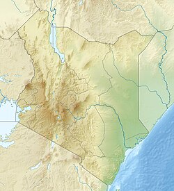
肯尼亚山
| 肯尼亚山 | |
|---|---|
 肯尼亚山 | |
| 最高点 | |
| 海拔 | 5,199米(17,057英尺) [1] |
| 地形突起度 | 3,825米(12,549英尺) [1] 第32位 |
| 列表 | 全国最高点 |
| 地理 | |
| 地形图 | 肯尼亚山(维洛霍夫斯基和萨维奇)[2][3] |
| 地质 | |
| 山脉类型 | 复式火山(死火山) |
| 最近喷发 | 2.6–3.1 MYA |
| 攀山 | |
| 首次登顶 | 1899年(哈尔福德·麦金德,随从向导塞萨尔·奥利耶和约瑟夫·布洛契尔) |
| 最简路线 | 攀岩 |
肯尼亚山(英语:Mount Kenya)为肯尼亚第一高峰及非洲第二高峰,仅次于乞力马扎罗山[4]。最高主峰为巴蒂安峰(5,199米(17,057英尺))、内利恩峰(5,188米(17,021英尺))及勒纳纳峰(4,985米(16,355英尺))。肯尼亚山位于肯尼亚中部,赤道以南约16.5千米(10.3英里),首都内罗毕东北偏北约150千米(93英里)[4]。肯尼亚共和国国名即来源于肯尼亚山。
肯尼亚山为一复式火山,于三百万年前随东非裂谷带形成而产生[5]。冰期到来前其海拔为7,000米(23,000英尺)。过去数千年来其为冰帽所覆盖,由此导致其极度侵蚀的山坡[6]及自中心发散的诸多峡谷[7]。目前肯尼亚山共有11座小型冰川。山坡植被覆盖率高,为肯尼亚提供了重要的水源[8]。
自山脚至山顶有诸多植被带[9],山坡下部由多种树林覆盖。诸多高山植物为肯尼亚特有,如巨型半边莲、黄菀及当地亚种蹄兔[10]。肯尼亚山中部面积715平方千米(276平方英里)的地区被指定为国家公园[11],于1997年成为联合国教科文组织世界遗产[12]。国家公园每年访客量超过16,000人[8]。
参考文献
- ^ 1.0 1.1 1.2 "Africa Ultra-Prominences" (页面存档备份,存于互联网档案馆) Peaklist.org. Retrieved 2012-02-06.
- ^ Mount Kenya Map Sample. Ewpnet.com. [16 April 2010]. (原始内容存档于2010年8月21日).
- ^ Mount Kenya Map and Guide (地图) 4th. 1:50,000 with 1:25,000 inset. EWP Map Guides. Cartography by EWP. EWP. 2007. ISBN 978-0-906227-96-1. (原始内容存档于2009-02-27).
- ^ 4.0 4.1 Rough Guide Map Kenya (地图) 9. 1:900,000. Rough Guide Map. Cartography by World Mapping Project. Rough Guide. 2006. ISBN 1-84353-359-6.
- ^ Philippe Nonnotte. Étude volcano-tectonique de la zone de divergence Nord-Tanzanienne (terminaison sud du rift kenyan) – Caractérisation pétrologique et géochimique du volcanisme récent (8 Ma – Actuel) et du manteau source – Contraintes de mise en place thèse de doctorat de l'université de Bretagne occidentale, spécialité : géosciences marines (PDF). [2016-08-31]. (原始内容存档 (PDF)于2011-07-22).
- ^ Gregory, J. W. Contributions to the Geology of British East Africa.-Part I. The Glacial Geology of Mount Kenya. Quarterly Journal of the Geological Society. 1894, 50: 515–530. doi:10.1144/GSL.JGS.1894.050.01-04.36.
- ^ Baker, B. H. Geology of the Mount Kenya area. Nairobi: Geological Survey of Kenya. 1967.
- ^ 8.0 8.1 Gichuki, Francis Ndegwa. Threats and Opportunities for Mountain Area Development in Kenya. Ambio (Royal Swedish Academy of Sciences). August 1999, 28 (5): 430–435. (原始内容存档于2005-12-31).
- ^ Resnick, Mike. Kirinyaga: a fable of Utopia. Ballantine. 1998: 293. ISBN 0-345-41701-1.
- ^ Coe, Malcolm James. The Ecology of the Alpine Zone of Mount Kenya. The Hague: Dr W. Junk. 1967.
- ^ World Heritage Nomination – IUCN Technical Evaluation Mount Kenya (Kenya) (PDF). [2016-08-31]. (原始内容存档 (PDF)于2011-09-19).
- ^ United Nations. Mount Kenya National Park/Natural Forest. 2008 [23 February 2008]. (原始内容存档于2006年12月30日).
| |||||||||||||||||
Text is available under the CC BY-SA 4.0 license; additional terms may apply.
Images, videos and audio are available under their respective licenses.

