For faster navigation, this Iframe is preloading the Wikiwand page for 翠榕桥.

翠榕桥

22°23′16″N 114°11′57″E / 22.3878°N 114.1993°E / 22.3878; 114.1993

翠榕桥
Banyan Bridge
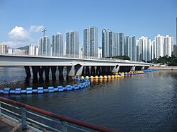
翠榕桥,摄于奥运期间城门河道西岸
坐标 22°23′16″N 114°11′57″E / 22.3878°N 114.1993°E / 22.3878; 114.1993
承载双向三行车线、人行道、脚踏车道
跨越城门河
地点沙田区城门河中游
设计参数
全长0.22公里
统计
通行费免费
地图
地图
Fo Tan Road
火炭路
道路长度1.7千米(1.1英里)
车速限制50/70公里每小时
车道数三线双程
地点香港香港新界
起点沙田区大涌桥路沙田路交界
终点沙田区火炭火炭工业区桂地街
翠榕桥与大涌桥路交界,远方建筑物为禾𪨶邨

翠榕桥(英语:Banyan Bridge)是香港的一条跨河行车桥,位于新界沙田沙田第一城大涌桥路交界)至香港专业教育学院沙田分校源禾路交界),横跨城门河中游一带,为火炭路的一部分,建于1980年代。旁为另一跨河行车桥锦龙桥

翠榕桥设有三线双程分隔车道,车道两旁则设有人行道及脚踏车道。

邻近主要建筑物

参见

参考资料

  • 香港街道大厦详图(通用图书有限公司出版)
{{bottomLinkPreText}} {{bottomLinkText}}
翠榕桥
Listen to this article

This browser is not supported by Wikiwand :(
Wikiwand requires a browser with modern capabilities in order to provide you with the best reading experience.
Please download and use one of the following browsers:

This article was just edited, click to reload
This article has been deleted on Wikipedia (Why?)

Back to homepage

Please click Add in the dialog above
Please click Allow in the top-left corner,
then click Install Now in the dialog
Please click Open in the download dialog,
then click Install
Please click the "Downloads" icon in the Safari toolbar, open the first download in the list,
then click Install
{{::$root.activation.text}}

Install Wikiwand

Install on Chrome Install on Firefox
Don't forget to rate us

Tell your friends about Wikiwand!

Gmail Facebook Twitter Link

Enjoying Wikiwand?

Tell your friends and spread the love:
Share on Gmail Share on Facebook Share on Twitter Share on Buffer

Our magic isn't perfect

You can help our automatic cover photo selection by reporting an unsuitable photo.

This photo is visually disturbing This photo is not a good choice

Thank you for helping!


Your input will affect cover photo selection, along with input from other users.

X

Get ready for Wikiwand 2.0 🎉! the new version arrives on September 1st! Don't want to wait?