穆斯林区
31°46′51″N 35°13′57″E / 31.78083°N 35.23250°E
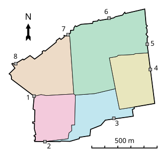
穆斯林区(阿拉伯语:حارة المسلمين;希伯来语:הרובע המוסלמי)是耶路撒冷旧城的四个分区之一。位于旧城的东北部,面积31公顷(76英亩)[1]穆斯林区是旧城四个分区中面积最大、人口最多的区,东到狮子门,南面沿着圣殿山的北墙,西到大马士革门—西墙一线。苦路开始于该区[2]。


穆斯林区的人口有22,000人[2]。如同旧城内其他三个区一样,在1929年巴勒斯坦骚乱之前,穆斯林区原本也是犹太人、穆斯林和基督徒杂居之地。今天有60户犹太家庭居住在穆斯林区。该区内的犹太地标有小西墙(Kotel Katan),和沿着西墙地下的西墙隧道。
2005年7月27日,以色列政府批准在穆斯林区3德南土地上兴建30套犹太人住宅,距离阿克萨清真寺仅有几米远[3]。
参考文献
[编辑]- ^ The Holy Land (页面存档备份,存于互联网档案馆), pg. 29.(此区域不包括占地35英亩的圣殿山)
- ^ 2.0 2.1 Muslim Quarter of the "Old City" section of Jerusalem Archive.is的存档,存档日期2012-12-20
- ^ New Jewish Settlement in Muslim Quarter of Jerusalem Old City near Al Aqsa Mosque could ignite a Third Intifada. [2010-01-24]. (原始内容存档于2008-10-07).
外部链接
[编辑]- HD Virtual Tour of the Muslim Quarter - December 2007 (页面存档备份,存于互联网档案馆)
- HD Virtual Tour of the Muslim Quarter - December 2007 (页面存档备份,存于互联网档案馆)
- HD Virtual Tour of a Souvenir shop in the Muslim Quarter - December 2007 (页面存档备份,存于互联网档案馆)
参见
[编辑]
| ||||||||||||||||||||||||||||||||||||||||||||||||||||||||||||||||||||||||||||||||||||||||||||||||||||||||||||||
| |||||||||||||||||||||||||||||||||||||||||||||
Text is available under the CC BY-SA 4.0 license; additional terms may apply.
Images, videos and audio are available under their respective licenses.


