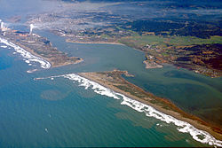
洪堡湾
| Humboldt Bay | |
|---|---|
 洪堡湾航拍图 | |
| 位置 | 洪堡县 北海岸 |
| 坐标 | 40°45′13.53″N 124°12′54.73″W / 40.7537583°N 124.2152028°W |
| 河流源 | 麋鹿河(Elk River)等 |
| 海洋源 | 太平洋 |
| 所在国家 | 美国 |
| 最大长度 | 14英里(23千米) |
| 最大宽度 | 4.5英里(7千米) |
| 表面积 | 13平方英里(34平方千米)/25.5平方英里(66平方千米)(最低/最高潮) (17,000英亩) |
| 平均深度 | 11英尺(3.4米) |
| 最大深度 | 40英尺(12米)(挖掘形成) |
| 岛屿 | 印第安岛、伍德利岛(Woodley Island)、达比岛(Daby Island) |
| 定居点 | 尤里卡、阿克塔 |
| 参考 | [1] |
加利福尼亚州历史地标 | |
| 官方名称 | Humboldt Harbor Historical District[2] |
| 参考编码 | 882 |
洪堡湾(Humboldt Bay)是美国加利福尼亚州北海岸的一个天然海湾[3]和潟湖。[4] 它整个都位于同名的洪堡县内,是美国西海岸旧金山湾到普吉特湾之间最大的受保护水体,[5] 也形成了旧金山和库斯湾之间最大的港口。[4] 这个海湾附近最大的城市是尤里卡,加上周边的聚居地,整个湾区人口将近八万,即80%的洪堡县人口。[6] 除去人类的聚居地外,这里还生活着100多种植物、300多种无脊椎动物、100多种鱼类和200多种鸟类。[7][8]
作为加利福尼亚州第二大河口,洪堡湾是西海岸最大的牡蛎养殖基地,超过半数的加利福尼亚州牡蛎都是养殖在这里的。[9] 洪堡湾港(偶尔也称尤里卡港)是一个深水港,有许多个码头用来装卸货物,此外湾区内还有无数个供小型船只及游艇使用的小码头。[10]
参考文献
- ^ Shellfish Growing Area Classification for Humboldt Bay Technical Report # 06-11 (PDF). California Department of Health Services. March 2006: 87 [13 December 2013]. (原始内容 (PDF)存档于2012年9月14日).
- ^ Humboldt Harbor Historical District. Office of Historic Preservation, California State Parks. [2012-10-07].
- ^ Humboldt Bay Management Plan Executive Summary (PDF). Humboldt Bay Harbor Recreation and Conservation District. May 2007 [13 December 2012]. (原始内容 (PDF)存档于2012年2月24日).
- ^ 4.0 4.1 Costa, Steven L.; Karen A. Glatzel. Coastal Inlets Research Program: Humboldt Bay, California Entrance Channel, Report 1: Data Review (PDF). U.S. Army Corps of Engineers. September 2002 [13 December 2012]. (原始内容存档 (PDF)于2012-09-29).
- ^ Schlosser, Susan; Annie Eicher. Humboldt Bay and Eel River Estuary Benthic Habitat Project (PDF). University of California San Diego: California Sea Grant College Program Publication No. T -075. 2012: 246 [13 December 2009]. (原始内容 (PDF)存档于2015年4月2日).
- ^ Draft Transit Dev Plan Humboldt County Systems. PMC/HDR. December 2011 [23 August 2013]. (原始内容存档于2017-05-25).
- ^ HUMBOLDT BAY SEA LEVEL RISE ADAPTATION PLAN (PDF). California Coastal Commission. 2012 [August 23, 2013]. (原始内容存档 (PDF)于2020-10-27).
- ^ WHSRN Humboldt Bay Complex. WESTERN HEMISPHERE SHOREBIRD RESERVE NETWORK. 2009 [August 23, 2013]. (原始内容存档于2017-05-25).
- ^ Pomeroy, Caroline; Cynthia J. Thomson and Melissa M. Stevens. California's North Coast Fishing Communities Historical Perspective and Recent Trends: Eureka Fishing Community Profile (PDF). National Oceans and Atmospheres Administration California Sea Grant Program. August 2010: 79 [9 December 2012]. (原始内容存档 (PDF)于2019-06-04).
- ^ Hills, Cody. Backyard of Boats. North Coast Journal, Eureka, California. 6 December 2012 [6 January 2013]. (原始内容存档于2013-01-11).
外部链接
Text is available under the CC BY-SA 4.0 license; additional terms may apply.
Images, videos and audio are available under their respective licenses.
