For faster navigation, this Iframe is preloading the Wikiwand page for 梅丘.

梅丘

梅丘
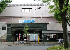
梅丘站北口
梅丘站北口
坐标:35°39′19″N 139°39′13″E / 35.6553°N 139.6536°E / 35.6553; 139.6536
国家 日本
都道府县 东京都
特别区 世田谷区
地域北泽地域
面积
 • 总计0.492 平方公里(0.190 平方英里)
人口(2013年(平成25年)9月1日)[1]
 • 总计8,763人
 • 密度17,811人/平方公里(46,130人/平方英里)
时区JSTUTC+9
邮递区号154-0022 

梅丘(日语:梅丘うめがおか Umegaoka */?)是东京都世田谷区的町名。现行行政地名为梅丘一丁目至梅丘三丁目。邮递区号为154-0022。

地理

位于世田谷区中央附近,属北泽地域。北邻松原,东接代田,南连若林世田谷,西通豪德寺。在地形上,北为北泽川,南有乌山川,地型大致平坦。

梅丘站位于此地北部。车站周边多商业用地,其他以住宅为主。

历史

古时属荏原郡世田谷村一部分与松原村飞地一部分。现在二、三丁目与世田谷、若林的连结依然紧密。

地名由来

梅丘的由来已不可考。一说是来自车站站名,因附近土地的所有者拥有梅钵家纹而得名。另一说是附近有称为“埋めヶ丘”的古坟,“埋め”后演变为“梅”而成为“梅丘”。此外,近邻的羽根木公园以梅林闻名,但其种植时间已有“梅丘”的站名与地名。

备注

相关条目

外部链接

{{bottomLinkPreText}} {{bottomLinkText}}
梅丘
Listen to this article

This browser is not supported by Wikiwand :(
Wikiwand requires a browser with modern capabilities in order to provide you with the best reading experience.
Please download and use one of the following browsers:

This article was just edited, click to reload
This article has been deleted on Wikipedia (Why?)

Back to homepage

Please click Add in the dialog above
Please click Allow in the top-left corner,
then click Install Now in the dialog
Please click Open in the download dialog,
then click Install
Please click the "Downloads" icon in the Safari toolbar, open the first download in the list,
then click Install
{{::$root.activation.text}}

Install Wikiwand

Install on Chrome Install on Firefox
Don't forget to rate us

Tell your friends about Wikiwand!

Gmail Facebook Twitter Link

Enjoying Wikiwand?

Tell your friends and spread the love:
Share on Gmail Share on Facebook Share on Twitter Share on Buffer

Our magic isn't perfect

You can help our automatic cover photo selection by reporting an unsuitable photo.

This photo is visually disturbing This photo is not a good choice

Thank you for helping!


Your input will affect cover photo selection, along with input from other users.

X

Get ready for Wikiwand 2.0 🎉! the new version arrives on September 1st! Don't want to wait?