柯士甸山道
22°16′22.044″N 114°8′52.908″E / 22.27279000°N 114.14803000°E
 柯士甸山道(左方公园则为柯士甸山游乐场,右方住宅为柯士甸山道8号) | |
| 道路长度 | 1.7千米(1.1英里) |
| 车速限制 | 50公里每小时 |
| 车道数 | 单线双向 |
| 地点 | 香港中西区太平山 |
| 起点 | 山顶道与芬梨道、夏力道交界 |
| 终点 | 山顶无线电站 |
| 建造 | |
| 通车 | 1862年或更早 |
柯士甸山道(英语:Mount Austin Road)是香港岛直通太平山山顶上的一条车路,也是香港岛海拔最高的道路,约540米或更高但绝不高于552米[1]。全程单线双向行车,上山斜坡路。柯士甸山道街口在炉峰峡凌霄阁以西,沿途经过柯士甸山游乐场、旧总督山顶别墅守卫室及山顶公园,止于无线电站。柯士甸山道沿途有住宅岫云、山景花园别墅、柯士甸山道8号、山顶花园、耕云草庐及丰林阁。
特色
在柯士甸山道8号北面,往卢吉道26C路口,有一风景点,游人多在此下车拍照。此处可以远眺湾仔、铜锣湾和北角的楼景,包括合和中心、中环广场及维多利亚东海峡,及九龙半岛尖沙咀及红磡。
-
 柯士甸山道中段观景亭所见之风景 (2006年)
 -
 柯士甸山道8号的观景亭
 -
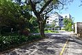 柯士甸山道近柯士甸山道22号
 -
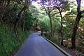 柯士甸山道近山顶公园


相关
- 同乐径
- 夏力道
外部链接
Text is available under the CC BY-SA 4.0 license; additional terms may apply.
Images, videos and audio are available under their respective licenses.
Cover photo is available under {{::mainImage.info.license.name || 'Unknown'}} license.
Cover photo is available under {{::mainImage.info.license.name || 'Unknown'}} license.
Credit:
(see original file).
