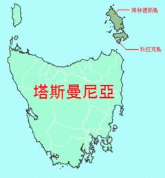
费莲达岛
| 费莲达岛 Flinders Island | |
|---|---|
 费莲达岛是弗诺群岛最大的岛屿 | |
 | |
| 词源 | 马修·福林达斯 |
| 地理 | |
| 位置 | 巴斯海峡 |
| 坐标 | 40°00′S 148°03′E / 40.000°S 148.050°E |
| 群岛 | 弗诺群岛 |
| 面积 | 1,367平方千米(528平方英里) |
| 面积排名 | 塔斯曼尼亚州第二大 |
| 长度 | 62千米(38.5英里) |
| 宽度 | 37千米(23英里) |
| 最高海拔 | 756米(2480英尺) |
| 最高点 | 斯切莱茨基山 (Mount Strzelecki) |
| 管辖 | |
澳洲 | |
| 州 | 塔斯曼尼亚州 |
| 地方政府 | 费莲达议会 |
| 最大聚居地 | Whitemark |
| 人口统计 | |
| 人口 | 1,010 |
| 人口密度 | 0.673人/平方公里(1.743人/平方英里) |
| 其他资料 | |
| 官方网站 | visitflindersisland |

费莲达岛(英语:Flinders Island),又称为弗林德斯岛,是澳洲塔斯曼尼亚州的岛屿,为弗诺群岛的最大岛,位处巴斯海峡。
国家公园和保护区
位于弗林德斯岛西南部的斯基里克兰基国家公园(Strzelecki National Park)占地42.16平方公里,国家公园内的斯基里克兰基峰(Strzelecki Peaks)是全岛的最高峰,海拔756米,此外岛上还设有众多保护区,国家公园和保护区约占到了弗林德斯岛三分之二以上的面积。岛上的保护区有:
- 温加鲁自然保护区(Wingaroo Nature Reserve)
- 福州保护区(Foochow Conservation Area)
- 族长保护区(Patriarchs Conservation Area)
- 塞拉斯泻湖禁猎区(Sellars Lagoon Game Reserve)
- 达令山脉保护区(Darling Range Conservation Area)
- 米利根山保护区(Mulligans Hill Conservation Area)
- 布劳汉塔糖山保护区(Brougham Sugarloaf Conservation Area)
- 沙格泄湖保护区(Shag Lagoon Conservation Area)
- 洛根泄湖保护区(Logan Lagoon Conservation Area)[1]
气候
| 费莲达岛机场(1991-2020年平均数据,1942年至今极端数据) | |||||||||||||
|---|---|---|---|---|---|---|---|---|---|---|---|---|---|
| 月份 | 1月 | 2月 | 3月 | 4月 | 5月 | 6月 | 7月 | 8月 | 9月 | 10月 | 11月 | 12月 | 全年 |
| 历史最高温 °C(°F) | 41.5 (106.7) |
39.4 (102.9) |
35.6 (96.1) |
31.7 (89.1) |
27.4 (81.3) |
20.3 (68.5) |
21.4 (70.5) |
22.7 (72.9) |
29.5 (85.1) |
32.7 (90.9) |
35.9 (96.6) |
40.5 (104.9) |
41.5 (106.7) |
| 平均高温 °C(°F) | 22.6 (72.7) |
22.7 (72.9) |
21.4 (70.5) |
18.7 (65.7) |
16.3 (61.3) |
14.3 (57.7) |
13.6 (56.5) |
13.9 (57.0) |
15.3 (59.5) |
17.0 (62.6) |
18.9 (66.0) |
20.7 (69.3) |
18.0 (64.4) |
| 平均低温 °C(°F) | 13.9 (57.0) |
14.1 (57.4) |
12.6 (54.7) |
10.6 (51.1) |
9.0 (48.2) |
7.1 (44.8) |
6.7 (44.1) |
6.8 (44.2) |
7.8 (46.0) |
8.7 (47.7) |
10.5 (50.9) |
12.3 (54.1) |
10.0 (50.0) |
| 历史最低温 °C(°F) | 2.6 (36.7) |
4.0 (39.2) |
1.6 (34.9) |
−0.4 (31.3) |
−1.7 (28.9) |
−2.5 (27.5) |
−3.5 (25.7) |
−3.0 (26.6) |
−2.5 (27.5) |
−1.4 (29.5) |
0.5 (32.9) |
2.5 (36.5) |
−3.5 (25.7) |
| 平均降水量 mm(吋) | 52.9 (2.08) |
32.3 (1.27) |
40.4 (1.59) |
50.6 (1.99) |
62.8 (2.47) |
68.3 (2.69) |
66.0 (2.60) |
72.5 (2.85) |
58.9 (2.32) |
47.2 (1.86) |
55.9 (2.20) |
57.0 (2.24) |
668.3 (26.31) |
| 平均降水天数(≥ 0.2 mm) | 8.1 | 7.3 | 8.5 | 11.6 | 14.6 | 15.9 | 17.0 | 17.3 | 14.5 | 12.3 | 10.0 | 10.2 | 147.3 |
| 月均日照时数 | 238.7 | 220.4 | 220.1 | 183.0 | 148.8 | 117.0 | 142.6 | 192.2 | 192.0 | 223.2 | 228.0 | 244.9 | 2,350.9 |
| 数据来源:Bureau of Meteorology[2][3] | |||||||||||||
参见
参考资料
- ^ 弗林德斯岛 Flinders Island. 澳洲无忧网.
- ^ Period 1991-2020. Climate statistics for Australian locations. Bureau of Meteorology. [16 March 2022].
- ^ Climate Statistics for FLINDERS ISLAND AIRPORT. Climate statistics for Australian locations. Bureau of Meteorology. [9 June 2017]. (原始内容存档于2015-11-17).
外部链接
Text is available under the CC BY-SA 4.0 license; additional terms may apply.
Images, videos and audio are available under their respective licenses.
