尖扎县
| 尖扎县 གཅན་ཚ་རྫོང་། | |
|---|---|
| 县 | |
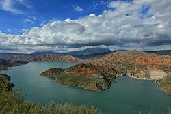
 从坎布拉国家森林公园鸟瞰李家峡水库 | |
 尖扎县在黄南藏族自治州和中国的位置 | |
| 坐标:35°56′14″N 102°01′48″E / 35.93712°N 102.03011°E | |
| 国家 | |
| 隶属行政区 | 青海省黄南藏族自治州 |
| 政府驻地 | 马克唐镇 |
| 面积 | |
| • 总计 | 1,557.85 平方公里(601.49 平方英里) |
| 人口(2020) | |
| • 总计 | 5.82万人 |
| 时区 | 北京时间(UTC+8) |
| 邮政编码 | 811200 |
| 电话区号 | 973 |
| 车辆号牌 | 青D |
| 行政区划代码 | 632322 |
尖扎县(藏语:གཅན་ཚ།,威利转写:gcan tsha,藏语拼音:Jainca)是中华人民共和国青海省黄南藏族自治州北部的一个县。与之接壤的县市有:东北部隔黄河与化隆县相望,东南边循化县,西边贵德县,南边同仁县。面积1714平方公里。县人民政府驻马克堂镇。
地理
尖扎县全县地势西高东低,最低海拔1960米,最高海拔4614米,相对高差为2654米[1]。河谷、低山丘陵和中高山地地域的垂直差异明显。境内山脉属西倾山余脉,西南到西北有折戈里山、戈尕山、色尖山、申宝山、扎马山等,海拔都在3500米以上[2]。
行政区划

人口
根据(青海省)黄南州第七次全国人口普查公报显示:尖扎县常住人口为58173人[4],男性人口占比50.27%,女性人口占比49.73%,年龄结构中0-14岁占比25.78%,15-59岁占比64.05%,60岁以上占比10.17%,65岁以上占比7.59%。
自然资源
水电资源
水电资源得天独厚,黄河纵贯尖扎县南北,在全县境内的流程达96公里。尖扎县建有李家峡、直岗拉卡、康杨、才塘、古浪堤和当顺6座水电站,总装机容量210.23万千瓦,是青海省重要的能源基地。黄河水域面积广阔。随着几座水电站的相继建成,全县境内已形成面积60平方公里的水域[5]。
气候
尖扎县有寒冷的半干旱气候(柯本气候分类法 BSK),2000年7月24日,青海的极端高温为40.3°C(104.5°F)。
| 尖扎县 | |||||||||||||
|---|---|---|---|---|---|---|---|---|---|---|---|---|---|
| 月份 | 1月 | 2月 | 3月 | 4月 | 5月 | 6月 | 7月 | 8月 | 9月 | 10月 | 11月 | 12月 | 全年 |
| 历史最高温 °C(°F) | 12.7 (54.9) |
18.2 (64.8) |
29.5 (85.1) |
34.5 (94.1) |
31.6 (88.9) |
33.1 (91.6) |
40.3 (104.5) |
36.0 (96.8) |
31.9 (89.4) |
26.0 (78.8) |
18.9 (66.0) |
12.8 (55.0) |
40.3 (104.5) |
| 平均高温 °C(°F) | 2.9 (37.2) |
6.6 (43.9) |
12.1 (53.8) |
18.1 (64.6) |
21.8 (71.2) |
24.5 (76.1) |
26.7 (80.1) |
26.0 (78.8) |
21.1 (70.0) |
15.8 (60.4) |
10.0 (50.0) |
4.2 (39.6) |
15.8 (60.5) |
| 日均气温 °C(°F) | −5.1 (22.8) |
−1.1 (30.0) |
4.4 (39.9) |
10.4 (50.7) |
14.6 (58.3) |
17.6 (63.7) |
19.7 (67.5) |
18.9 (66.0) |
14.4 (57.9) |
8.5 (47.3) |
1.7 (35.1) |
−4.0 (24.8) |
8.3 (47.0) |
| 平均低温 °C(°F) | −11.3 (11.7) |
−7.3 (18.9) |
−1.5 (29.3) |
4.0 (39.2) |
8.2 (46.8) |
11.4 (52.5) |
13.6 (56.5) |
13.2 (55.8) |
9.4 (48.9) |
3.1 (37.6) |
−4.5 (23.9) |
−9.9 (14.2) |
2.4 (36.3) |
| 历史最低温 °C(°F) | −18.8 (−1.8) |
−16.4 (2.5) |
−13.7 (7.3) |
−6.8 (19.8) |
−1.5 (29.3) |
3.5 (38.3) |
5.6 (42.1) |
6.9 (44.4) |
1.2 (34.2) |
−7.5 (18.5) |
−14 (7) |
−18.7 (−1.7) |
−18.8 (−1.8) |
| 平均降水量 mm(吋) | 0.7 (0.03) |
0.7 (0.03) |
5.0 (0.20) |
16.1 (0.63) |
47.7 (1.88) |
56.9 (2.24) |
74.7 (2.94) |
70.2 (2.76) |
55.1 (2.17) |
18.4 (0.72) |
1.3 (0.05) |
0.4 (0.02) |
347.2 (13.67) |
| 数据来源:中国气象局,[6] | |||||||||||||
参考文献
- ^ 尖扎城市介绍. 中国天气网. [2017-09-02]. (原始内容存档于2017-09-04).
- ^ 尖扎县概况. 青海新闻网. [2017-09-02]. (原始内容存档于2017-09-04).
- ^ 2023年尖扎县统计用区划代码和城乡划分代码. 中华人民共和国国家统计局. 2023-06-30 (中文(中国大陆)).
- ^ 中國: 青海省 (地级行政、县级行政区) - 人口统计,图表和地图. www.citypopulation.de. [2023-10-16]. (原始内容存档于2023-10-25).
- ^ 5.0 5.1 尖扎概况. 尖扎新闻网. [2017-09-02]. (原始内容存档于2018-05-02).
- ^ 中国地面国际交换站气候标准值月值数据集(1981-2010年). 中国气象局. [2011-01-01]. (原始内容存档于2018-09-05).
外部链接
| ||||||||||||||||||||||
| |||||||||||||||||||||||||||||||||||||||||||||||||||||||||||||||||||||
| |||||||||||||||||||||||||||||||||||||||||||||||||||||||||||||||||
Text is available under the CC BY-SA 4.0 license; additional terms may apply.
Images, videos and audio are available under their respective licenses.


