For faster navigation, this Iframe is preloading the Wikiwand page for 布罗莫火山.

布罗莫火山

布罗莫火山
最高点
海拔2,329米(7,641英尺) [1]
坐标7°56′30″S 112°57′00″E / 7.94167°S 112.95000°E / -7.94167; 112.95000[1]
地理
布罗莫火山在印度尼西亚的位置
布罗莫火山
布罗莫火山
地质
山脉类型复式火山
最近喷发2015年

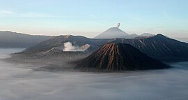
布罗莫火山又译作婆罗摩火山,是印度尼西亚火山,位于爪哇岛东部,行政方面由东爪哇省负责管辖,海拔高度2,329米,火山口的南北向直径为800米、东西向直径为600米,位于东爪哇岛泗水东南,相距大约150公里。它位于唐格尔山(Tengger)的巨大火山口之内。登格尔山大约于80万年前形成,如今火山口直径足足有10公里之阔。其后这个大型火山又再爆发,在广阔的盆地上相继诞生了婆罗摩火山,Mt Batok 和塞梅鲁火山。这个高原上有村落,村落尽头有悬崖,悬崖下是沙海盆地,盆地中央有火山口的奇特景观。[2]最近一次喷发发生在2015年。

参考资料

  1. ^ 1.0 1.1 Tengger Caldera. 全球火山作用计划. 史密森尼学会. 
  2. ^ Henry Lo. 風光風情結合 印尼婆羅摩火山. AM730. 2012年3月20日 [2012-03-28]. (原始内容存档于2016-03-04). 

外部链接

{{bottomLinkPreText}} {{bottomLinkText}}
布罗莫火山
Listen to this article

This browser is not supported by Wikiwand :(
Wikiwand requires a browser with modern capabilities in order to provide you with the best reading experience.
Please download and use one of the following browsers:

This article was just edited, click to reload
This article has been deleted on Wikipedia (Why?)

Back to homepage

Please click Add in the dialog above
Please click Allow in the top-left corner,
then click Install Now in the dialog
Please click Open in the download dialog,
then click Install
Please click the "Downloads" icon in the Safari toolbar, open the first download in the list,
then click Install
{{::$root.activation.text}}

Install Wikiwand

Install on Chrome Install on Firefox
Don't forget to rate us

Tell your friends about Wikiwand!

Gmail Facebook Twitter Link

Enjoying Wikiwand?

Tell your friends and spread the love:
Share on Gmail Share on Facebook Share on Twitter Share on Buffer

Our magic isn't perfect

You can help our automatic cover photo selection by reporting an unsuitable photo.

This photo is visually disturbing This photo is not a good choice

Thank you for helping!


Your input will affect cover photo selection, along with input from other users.

X

Get ready for Wikiwand 2.0 🎉! the new version arrives on September 1st! Don't want to wait?