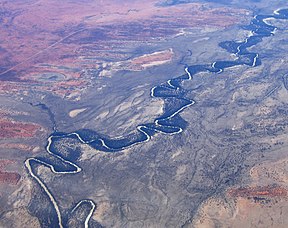
墨累-大令盆地
| Murray-Darling | |
|---|---|
 盆地西部航拍图 | |
 | |
| 长度 | 3,375千米(2,097哩) |
| 面积 | 1,061,469平方千米(409,835平方哩) |
| 地理 | |
| 国家 | 澳大利亚 |
| 州 | 昆士兰州、新南威尔斯州、维多利亚州、南澳大利亚州、澳大利亚首都领地 |
| 坐标 | 35°35′S 138°53′E / 35.583°S 138.883°E |
| 河流 | 墨累河、达令河、沃里戈河、马兰比季河、拉克兰河、古尔本河、坎帕斯皮河、米塔米塔河、洛登河等 |
墨累—大令盆地(英语:Murray–Darling Basin)长3,370公里,流域含盖澳大利亚七分之一陆地面积,是目前澳大利亚最重要的农业区域[1]。此流域的命名是由该流域的两条主要河流——墨累河与大令河而来。
面积1,061,469平方公里的流域大部分是地势低平的内陆地区,而且降雨量稀少。该流域包含的许多河川都属长型慢流速河流,水量若以澳大利亚标准来说非常丰沛。

参考
- ^ Pigram, John J. Australia's Water Resources: From use to management. Collingwood, Victoria: CSIRO Publishing. 2007: 160–162. ISBN 978-0-643-09442-0.
外交连结
- Murray–Darling Basin Authority (页面存档备份,存于互联网档案馆)
- Murray–Darling Basin Water Budget Project (页面存档备份,存于互联网档案馆)
- Murray Darling Freshwater Research Centre (页面存档备份,存于互联网档案馆)
- River Murray Water Restrictions
- Murray Outback - Guide to the major towns on the Murray and Murray Outback Region. (页面存档备份,存于互联网档案馆)
- Save the Murray - lobby group
- Murray Darling Basin Resources[失效链接]
- The Basin Plan
- Guide to the Proposed Basin Plan
- Guide to the Basin Plan, Volumes 1 - 21
- Basin Plan (页面存档备份,存于互联网档案馆) - lobby group
- 新闻
- Fire, Flood and Acid Mud, Catalyst, Australian Broadcasting Corporation, (原始内容存档于19 April 2016)
|
Text is available under the CC BY-SA 4.0 license; additional terms may apply.
Images, videos and audio are available under their respective licenses.
