埃内韦塔克环礁
| 埃内韦塔克环礁 | |
|---|---|
 | |
| 地理 | |
 埃内韦塔克环礁 (马绍尔群岛) | |
| 位置 | 太平洋北部 |
| 坐标 | 11°30′N 162°20′E / 11.500°N 162.333°E |
| 群岛 | 拉利克礁链 |
| 总岛屿 | 40 |
| 面积 | 5.85平方公里 |
| 最高海拔 | 5米(16英尺) |
| 管辖 | |
| 人口统计 | |
| 人口 | 853(1998) |
埃内韦塔克环礁(英语:Enewetak Atoll)是西太平洋中一个由40个岛屿组成的环礁,属于拉利克礁链的一部分。该岛群是马绍尔群岛24个立法选区(legislative district)之一,位于比基尼环礁以西305公里,是拉利克礁链的最西端岛屿,总土地面积少于5.85平方公里,中央的潟湖湖岸线长度80公里,1998年统计时的人口为853人。马绍尔群岛在第二次世界大战结束后直至1986年独立间一直受美国管治,1948年至1958年期间美国在埃内韦塔克环礁附近进行43次核爆测试,并在1952年11月1日进行的第一次氢弹测试中,把伊鲁吉拉伯岛炸毁。
-
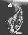 埃内韦塔克环礁岛瞰图
 -
 1952年氢弹测试
 -
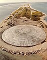 阻碍放射性物质的圆形水泥穹顶
 -
 马绍尔群岛地图,其中标示出了埃内韦塔克环礁

.jpg)


外部链接
- Marshall Islands site (页面存档备份,存于互联网档案馆)
- Entry at Oceandots.com(页面存档备份,存于互联网档案馆)
- Annotated bibliography for Eniwetok Atoll from the Alsos Digital Library for Nuclear Issues
- Information on legal judgements to the people of Enewetak(页面存档备份,存于互联网档案馆)
- Nursing a nuclear test hangover (页面存档备份,存于互联网档案馆) (www.watoday.com.au report on Runit Dome, August 18, 2008)
| |||||||||||||||||
| |||||||||||||||||
| ||||||||||||||||||||||||||||
Text is available under the CC BY-SA 4.0 license; additional terms may apply.
Images, videos and audio are available under their respective licenses.
Cover photo is available under {{::mainImage.info.license.name || 'Unknown'}} license.
Cover photo is available under {{::mainImage.info.license.name || 'Unknown'}} license.
Credit:
(see original file).
