图案地面


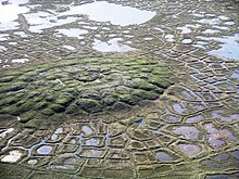
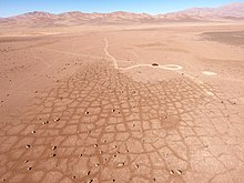
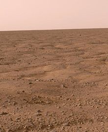
图案地面(Patterned ground)是冰缘区地表材料变形形成的独特且通常对称的几何形自然形态,它通常出现在偏远的北极地区、南极洲和澳大利亚内陆区,但也存在于所有土壤冻融交替的地方,在极度干旱的阿塔卡马沙漠和火星上也观察到了图案地面[2][3]。与图案地面相关的几何形状和图案常被误认为是人类的艺术创作。图案地面的形成机制长期以来一直困扰着科学家,但过去20年中计算机地质模型生成的引入,使科学家能够将它们与冻胀—潮湿环境下,细粒多孔的土壤冻结时产生的膨胀联系起来。
类型
[编辑]图案地面有各种形式。通常,给定区域内的图案地面类型与局部土壤中较大石块含量和冻融循环的频率有关[4][5][6][7][8][9]。

多边形
[编辑]
多边形可在永久冻土层(如冰楔)或受季节性霜冻影响的区域形成。构成这些凸起石环的岩石[6]。
在加拿大北方针叶林北部流域,当沼泽达到富营养化高潮并形成莎草垫时, 塔玛拉克落叶松(Tamarack Larch)和黑云杉(Black Spruce)通常是这种多边形莎草垫高潮期的早期定居者[10]。
圆圈
[编辑]
圆圈的大小从数厘米到数米不等,圆圈可以由分类和未分类的材质构成,通常在中心会出现细粒沉积物,周围有一圈较大的石块。未分类的圆也类似,但它们不是被较大的石块环绕,而是以一圈植被边缘为界线[11][6]。
台阶
[编辑]台阶可以从圆形和多边形展开,这种形式的图案地面通常是一种阶地状特征,在下坡侧有较大的石头或植被边界,可以由分类或未分类的材料构成[4][6]。
条纹
[编辑]“条纹”一般是构成坡度为2°至7°过渡阶坡的岩石、植被和/或土壤带。条纹可以由分类或未分类的材质组成。分类的条纹是被较小岩石、细粒沉积物或植被区隔开的较大岩石带;而未分类的条纹通常则由裸露的地面隔开的植被或土壤带[12][13][6]。
形成
[编辑]
在冰缘地区和受季节性霜冻影响的地区,由于较小的岩石在较大岩石下面流动和沉淀,地下水的反复冻融使得较大的岩石被推挤向地表。在地表,含大石块多的区域其含水量较细粒沉积物集中的高多孔区要少得多。当冻融发生时,这些较细沉积物的饱水区具有更大的膨胀收缩力,导致侧向力最终将较大的岩石堆积成簇状和条带状。随着时间的推移,反复的冻融循环会使不规则和奇形怪状的堆积物变得平滑,形成常见的多边形、圆形和条纹图案地面[14]。
图案地面会出现在冻融交替循环的高山地区,例如,在肯尼亚山一些地方,季节性霜冻层就位于地表下数厘米(英寸)处[1],因此在穆吉丘(Mugi Hill)以西3400米(11155英尺)的地方就出现了图案地面[15]。这些土丘的生长是因为土地反复冻融,吸收了更多的水。大约4000米(13123英尺)左右的地块表面开裂形成六边形,当夜间温度使土壤冻结,然后在早晨再次解冻时,就会发生冻融作用。土壤每天的膨胀和收缩阻止了植被的形成[16]。
霜冻也会对地面沉积物进行分类,一旦覆盖层风化,较细的颗粒倾向于从冻结边缘移走,而更大的颗粒则通过重力作用迁移。图案地面主要形成于永久冻土带的活动层内[14][17]。
另请参阅
[编辑]参考文献
[编辑]- ^ 1.0 1.1 Grab, Stefan W.; Gatebe, Charles K.; Kinyua, Antony M. Ground Thermal Profiles from Mount Kenya, East Africa. Geografiska Annaler: Series A, Physical Geography. 2004, 86 (2): 131–141. ISSN 0435-3676. JSTOR 3566103. doi:10.1111/j.0435-3676.2004.00219.x.
- ^ 2.0 2.1 Sager, Christof; Airo, Alessandro; Arens, Felix L.; Schulze-Makuch, Dirk. New type of sand wedge polygons in the salt cemented soils of the hyper-arid Atacama Desert. Geomorphology. 2021-01-15, 373: 107481 [2021-08-10]. ISSN 0169-555X. doi:10.1016/j.geomorph.2020.107481
 . (原始内容存档于2021-08-10) (英语).
- ^ Southern Hemisphere Polygonal Patterned Ground. Mars Global Surveyor: Mars Orbiter Camera. Malin Space Science Systems. [8 November 2013]. (原始内容存档于2016-10-27).
- ^ 4.0 4.1 Patterned Ground. [21 September 2016]. (原始内容存档于2017-03-29).
- ^ Ballantyne, C.K. Non-sorted patterned ground on mountains in the Northern Highlands of Scotland. Biuletyn Peryglacjalny. 1986, 30: 15–34.
- ^ 6.0 6.1 6.2 6.3 6.4 Allaby, Michael. A Dictionary of Geology and Earth Sciences. Oxford University Press. 2013: 429. ISBN 978-0-19-107895-8.
- ^ Ólafur, Ingólfsson. Glacial Geology Photos. 2006 [March 4, 2007]. (原始内容存档于2011-09-01).
- ^ Kessler M.A.; Werner B.T. Self-organization of sorted patterned ground. Science. January 2003, 299 (5605): 380–3. PMID 12532013. doi:10.1126/science.1077309.
- ^ Marchant, D.R.; Lewis, A.R.; Phillips, W.M.; Moore, E.J.; Souchez, R.A.; Denton, G.H.; Sugden, D.E.; Potter Jr., N.; Landis, G.P. Formation of Patterned Ground and Sublimation Till over Miocene Glacier Ice in Beacon Valley, Southern Victoria Land, Antarctica. Geological Society of America Bulletin. 2002, 114 (6): 718–730. doi:10.1130/0016-7606(2002)114<0718:fopgas>2.0.co;2.
- ^ C. Michael Hogan. 2008. Black Spruce: Picea mariana, GlobalTwitcher.com, ed. N. Stromberg (页面存档备份,存于互联网档案馆)
- ^ Hallet, Bernard. Stone circles: form and soil kinematics. Phil. Trans. R. Soc. Lond. A. 2013, 371 (2004): 20120357. PMID 24191111. doi:10.1098/rsta.2012.0357
 .
.
- ^ King, R. B. Boulder polygons and stripes in the Cairngorm Mountains, Scotland. Journal of Glaciology. 1971, 10 (60): 375–386. doi:10.1017/s0022143000022073
 .
.
- ^ Ballantyne, Colin K. The sorted stone stripes of Tingo Hill. Scottish Geographical Journal. 2001, 117 (4): 313–324. doi:10.1080/00369220118737131.
- ^ 14.0 14.1 Easterbrook, Don J. Surface processes and landforms 2nd. Prentice Hall. 1999: 418–422. ISBN 978-0-13-860958-0.
- ^ Baker, B. H. Geology of the Mount Kenya area; degree sheet 44 N.W. quarter (with coloured map). Nairobi: Geological Survey of Kenya. 1967.
- ^ Allan, Iain. The Mountain Club of Kenya Guide to Mount Kenya and Kilimanjaro. Nairobi: Mountain Club of Kenya. 1981. ISBN 978-9966985606.
- ^ Perkins, S. Patterns from Nowhere; Natural Forces Bring Order to Untouched Ground. Science News. 17 May 2003, 163 (20): 314–316 [2021-08-10]. JSTOR 4014632. doi:10.2307/4014632. (原始内容存档于2009-02-15).
外部链接
[编辑]Text is available under the CC BY-SA 4.0 license; additional terms may apply.
Images, videos and audio are available under their respective licenses.
