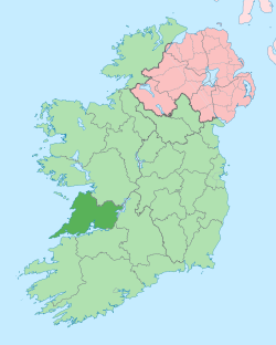
克莱尔郡
| 克莱尔郡 Contae an Chláir | ||
|---|---|---|
| ||
| 格言:Dílis d'ar nOidreacht (Irish) "True to our heritage" | ||
 | ||
| 坐标:52°50′00″N 9°00′00″W / 52.833333333333°N 9°W | ||
| 国家 | 爱尔兰 | |
| 省份 | 芒斯特 | |
| 议会选区 | 克莱尔 | |
| 欧盟议会选区 | 南 | |
| 郡治 | 恩尼斯 | |
| 政府 | ||
| • 类型 | 郡议会 | |
| 面积 | ||
| • 总计 | 3,450 平方公里(1,330 平方英里) | |
| 面积排名 | 第7位 | |
| 人口(2011) | ||
| • 总计 | 117,196人 | |
| • 排名 | 第19位 | |
| 车牌 | CE | |
| 网站 | www | |
克莱尔郡(County Clare;爱尔兰语:Contae an Chláir)是爱尔兰的一个郡,位于爱尔兰岛西岸,东以德格湖-香农河为界。历史上属芒斯特省。面积3,147平方公里。2011年人口117,196人。首府恩尼斯。[1]
地理和行政区划
克莱尔位于香农河西北方,总面积约3400平方公里(1300平方英里)。克莱尔是爱尔兰传统32郡中,面积第七大,人口排名第19名。克莱尔的绰号为旗帜县。[2]
城镇和村庄
- Ardnacrusha
- Ballynacally
- Ballyvaughan
- Barefield
- Broadford
- Bunratty
- Carrigaholt
- Carron
- Clarecastle
- Clonlara
- Connolly
- Cooraclare
- Corofin
- Cratloe
- Cree (Creegh)
- Cross
- Crusheen
- Doolin
- Doonaha
- Doonbeg
- Doora
- Ennis
- Ennistymon
- Fanore
- Feakle
- Inagh
- Inch
- Kilbaha
- Kilfenora
- Kilkee
- Kildysart
- Killaloe
- Killimer
- Kilmaley
- Kilmihil
- Kilmurry McMahon
- Kilnaboy
- Kilnamona
- Kilrush
- Lahinch
- Liscannor
- Lisdoonvarna
- Lissycasey
- Meelick
- Miltown Malbay
- Mountshannon
- Mullagh
- Newmarket-on-Fergus
- O'Briensbridge
- Ogonnelloe
- Parteen
- Quilty
- Quin
- Ruan
- Scariff
- Shannon
- Sixmilebridge
- Tuamgraney
- Tubber
- Tulla
- Whitegate
自然地理

克莱尔郡的边界大至由水域划分。东南方是爱尔兰最长的河流香农河,郡的南方则是香农河口。郡界向东北方向为德格湖是爱尔兰第三大湖泊。西面是大西洋,北部至戈尔韦湾。 克莱尔郡内的布伦,是独特的喀斯特地貌区,区内有珍贵花卉和物种。布伦的西部面至大西洋,这里有著名的莫赫悬崖。克莱尔郡的最高点位于玛伊欧莎山(532米),斯里贝尔纳山[3] 位于郡的东部。下列岛屿位在郡的外海:
- 欧威希
- 鹿岛
- 羊岛
- 斯卡特律岛
气候
| 克莱尔郡 | |||||||||||||
|---|---|---|---|---|---|---|---|---|---|---|---|---|---|
| 月份 | 1月 | 2月 | 3月 | 4月 | 5月 | 6月 | 7月 | 8月 | 9月 | 10月 | 11月 | 12月 | 全年 |
| 平均高温 °C(°F) | 8.1 (46.6) |
8.5 (47.3) |
10.4 (50.7) |
12.7 (54.9) |
15.3 (59.5) |
17.8 (64.0) |
19.3 (66.7) |
19.1 (66.4) |
17.1 (62.8) |
14.1 (57.4) |
10.4 (50.7) |
8.9 (48.0) |
13.5 (56.3) |
| 平均低温 °C(°F) | 2.6 (36.7) |
2.7 (36.9) |
3.6 (38.5) |
4.8 (40.6) |
7.3 (45.1) |
10 (50) |
12 (54) |
11.7 (53.1) |
10.1 (50.2) |
7.9 (46.2) |
4.5 (40.1) |
3.6 (38.5) |
6.7 (44.1) |
| 平均降水量 mm(吋) | 99 (3.9) |
74 (2.9) |
69 (2.7) |
58 (2.3) |
61 (2.4) |
66 (2.6) |
74 (2.9) |
89 (3.5) |
84 (3.3) |
97 (3.8) |
97 (3.8) |
110 (4.2) |
990 (38.8) |
| 数据来源:Clare Tour[4] | |||||||||||||
资料来源
注释
- ^ Census 2011 - County Clare Overview. [2012-10-03]. (原始内容存档于2017-08-25).
- ^ Clare, The Banner County - World Cultures European. Irishcultureandcustoms.com. [2012-04-19]. (原始内容存档于2020-11-20).
- ^ NB: not related to the Slieve Bearnagh mountain in County Down.
- ^ Climate. Clare-Tour.com. 25 December 2008 [2012-10-03]. (原始内容存档于2020-09-21).
参考文献
- Anthon, Charles. A Classical Dictionary. Harvard University. 1855 [2012-10-03]. (原始内容存档于2016-04-26).
- O'Laughlin, Michael C. The Families of County Clare, Ireland. Irish Roots Cafe. 2000 [2012-10-03]. ISBN 0-940134-98-5. (原始内容存档于2016-04-25).
- The Four Masters. "The Annals of Ireland by the Four Masters" as translated by Owen Connellan. Irish Roots Cafe. 2003 [2012-10-03]. ISBN 0-940134-14-4. (原始内容存档于2016-05-06).
外部链接
- War Of Independence in Clare
- Clare County Council (页面存档备份,存于互联网档案馆)
- Clare County Library (页面存档备份,存于互联网档案馆)
- Tourist Attractions (页面存档备份,存于互联网档案馆)
52°50′N 9°00′W / 52.833°N 9.000°W
| ||||||||||||||||||||||||||||||||||||||||||||||||
Text is available under the CC BY-SA 4.0 license; additional terms may apply.
Images, videos and audio are available under their respective licenses.

