Tập tin:Czechoslovakia.png
Kích thước hình xem trước: 800×407 điểm ảnh. Độ phân giải khác: 320×163 điểm ảnh | 640×325 điểm ảnh | 1.188×604 điểm ảnh.
Tập tin gốc (1.188×604 điểm ảnh, kích thước tập tin: 69 kB, kiểu MIME: image/png)
Tập tin này từ Wikimedia Commons. Trang miêu tả nó ở đấy được sao chép dưới đây. Commons là kho lưu trữ tập tin phương tiện có giấy phép tự do. Bạn có thể tham gia. |

|
Hình ảnh thuộc thể loại "historical map" cần được vẽ lại bằng đồ họa vector theo định dạng tập tin SVG. Để biết ưu điểm của định dạng này, hãy đọc Commons:Media for cleanup. Nếu tập tin này đã có SVG, xin hãy tải lên đây rồi thay bản mẫu này bằng ((vector version available|tên hình mới.svg)).
|
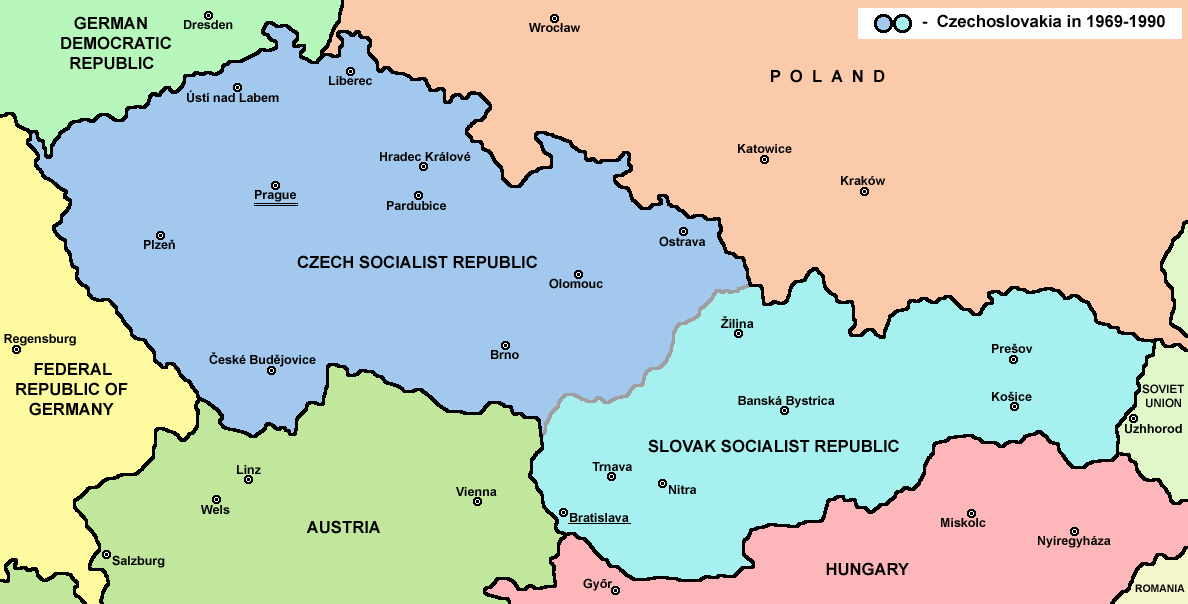
Miêu tả
| Miêu tả |
English: Map of Czechoslovakia in 1969-1990 |
| Nguồn gốc | Tác phẩm được tạo bởi người tải lên |
| Tác giả | PANONIAN |
| Phiên bản khác | Derivative works of this file: |


Giấy phép
| |
Tác phẩm này đã được tác giả của nó, PANONIAN tại Wikimedia Commons Tiếng Anh, phát hành vào phạm vi công cộng. Điều này có hiệu lực trên toàn thế giới. Trong trường hợp không khả thi về mặt luật pháp: |
References
Main reference:
- Map is created according to this external source: http://www.tcnj.edu/~guhr2/images/czechoslovakia.jpg archive copy at the Wayback Machine
Secondary references with similar maps:
- http://1.bp.blogspot.com/_Qe1wgxDiEdU/TGti_qWpeYI/AAAAAAAABo0/sSqAfIpQMuU/s1600/1213M_CS.gif
- https://jspivey.wikispaces.com/file/view/T010895A.gif/34419939/T010895A.gif
- http://media.web.britannica.com/eb-media/84/105684-050-0D8412E3.gif archive copy at the Wayback Machine
- http://www.gatheringofisrael.com/atlas/europe/slavic/CS_prague.gif
- http://collections.lib.uwm.edu/agsmap/images/lg/DSCN1455.jpg[dead link]
- http://leccos.com/pics/pic/ceskoslovensko-_mapa_1950.jpg archive copy at the Wayback Machine
- http://www.math.sk/knor/GIF/mapa.gif
- http://ckpaji.sweb.cz/ceskoslovensko.jpg archive copy at the Wayback Machine
- http://www.power.szm.com/historia/mapa_TV_vysielacov_1978.jpg
Secondary references about Geo-political situation - published sources:
- The Times History of Europe, Times Books, London, 2002.
- Richard Overy, The Times History of the 20th Century, Times Books, London, 2004.
- The Times Atlas svjetske povijesti, Cankarjeva založba, Ljubljana - Zagreb, 1986.
- Istorijski atlas, Geokarta, Beograd, 1999.
- Školski istorijski atlas, Zavod za izdavanje udžbenika SR Srbije, Beograd, 1970.
- Povijesni atlas, Učila - Zagreb, Zagreb, 1971.
- Povijesni atlas za osnovnu školu, Kartografija - Tlos, Zagreb, 1975.
- Denis Šehić - Demir Šehić, Istorijski atlas sveta, Beograd, 2007.
Secondary reference about sizable cities:
|
|
Hình ảnh thuộc thể loại "map" cần được vẽ lại bằng đồ họa vector theo định dạng tập tin SVG. Để biết ưu điểm của định dạng này, hãy đọc Commons:Media for cleanup. Nếu tập tin này đã có SVG, xin hãy tải lên đây rồi thay bản mẫu này bằng ((vector version available|tên hình mới.svg)).
|
The production, editing or release of this file was supported by the Community-Budget of Wikimedia Deutschland. To see other files made with the support of Wikimedia Deutschland, please see the category Supported by Wikimedia Deutschland. |
Lịch sử tập tin
Nhấn vào ngày/giờ để xem nội dung tập tin tại thời điểm đó.
| Ngày/giờ | Hình xem trước | Kích cỡ | Thành viên | Miêu tả | |
|---|---|---|---|---|---|
| hiện tại | 14:45, ngày 12 tháng 7 năm 2022 | | 1.188×604 (69 kB) | Sebastian Wallroth | CROPPED |
| 17:38, ngày 12 tháng 2 năm 2017 |  | 1.221×652 (69 kB) | WikiEditor2004 | Reverted to version as of 11:00, 24 April 2011 (UTC) - why you uploading polish version over english one? upload polish version under different filename | |
| 15:18, ngày 9 tháng 2 năm 2017 |  | 1.221×652 (57 kB) | Kelvin | Reverted to version as of 15:13, 9 February 2017 (UTC) | |
| 15:17, ngày 9 tháng 2 năm 2017 |  | 1.221×652 (69 kB) | Kelvin | Reverted to version as of 11:00, 24 April 2011 (UTC) | |
| 15:13, ngày 9 tháng 2 năm 2017 |  | 1.221×652 (57 kB) | Kelvin | Polish names of countries /Polskie określenia krajów | |
| 11:00, ngày 24 tháng 4 năm 2011 |  | 1.221×652 (69 kB) | WikiEditor2004 | correction | |
| 10:27, ngày 23 tháng 4 năm 2011 |  | 1.221×652 (69 kB) | WikiEditor2004 | improved version | |
| 23:31, ngày 10 tháng 12 năm 2006 |  | 1.200×624 (19 kB) | Severino666~commonswiki | Map of Czechoslovakia (self made) Category:Maps of Czechoslovakia Category:Maps of Czech history Category:Maps of the history of Slovakia Category:Maps of the history of Central Europe ((PD)) |
Trang sử dụng tập tin
Có 2 trang tại Wikipedia tiếng Việt có liên kết đến tập tin (không hiển thị trang ở các dự án khác):
Sử dụng tập tin toàn cục
Những wiki sau đang sử dụng tập tin này:
- Trang sử dụng tại ang.wikipedia.org
- Trang sử dụng tại an.wikipedia.org
- Trang sử dụng tại ar.wikipedia.org
- Trang sử dụng tại azb.wikipedia.org
- Trang sử dụng tại az.wikipedia.org
- Trang sử dụng tại ba.wikipedia.org
- Trang sử dụng tại bcl.wikipedia.org
- Trang sử dụng tại be-tarask.wikipedia.org
- Trang sử dụng tại be.wikipedia.org
- Trang sử dụng tại bg.wikipedia.org
- Trang sử dụng tại bn.wikipedia.org
- Trang sử dụng tại br.wikipedia.org
- Trang sử dụng tại bs.wikipedia.org
- Trang sử dụng tại ca.wikipedia.org
- Trang sử dụng tại cv.wikipedia.org
- Trang sử dụng tại da.wikipedia.org
- Trang sử dụng tại de.wikipedia.org
- Trang sử dụng tại dsb.wikipedia.org
- Trang sử dụng tại el.wikipedia.org
- Trang sử dụng tại en.wikipedia.org
- Czechoslovakia
- History of Slovakia
- History of Czechoslovakia (1948–1989)
- History of Czechoslovakia (1989–1992)
- Economy of communist Czechoslovakia
- History of Czechoslovakia
- Dissolution of Czechoslovakia
- Czechoslovak Socialist Republic
- Portal:Slovakia
- She Grazed Horses on Concrete
- Rugby union in Czechoslovakia
Xem thêm các trang toàn cục sử dụng tập tin này.
Đặc tính hình
Text is available under the CC BY-SA 4.0 license; additional terms may apply.
Images, videos and audio are available under their respective licenses.
Cover photo is available under {{::mainImage.info.license.name || 'Unknown'}} license.
Cover photo is available under {{::mainImage.info.license.name || 'Unknown'}} license.
Credit:
(see original file).
