Tập tin:1780 Raynal and Bonne Map of Southeast Asia and the Philippines - Geographicus - Philippines-bonne-1780.jpg
Kích thước hình xem trước: 800×554 điểm ảnh. Độ phân giải khác: 320×222 điểm ảnh | 640×443 điểm ảnh | 1.024×709 điểm ảnh | 1.280×886 điểm ảnh | 2.500×1.731 điểm ảnh.
Tập tin gốc (2.500×1.731 điểm ảnh, kích thước tập tin: 1,35 MB, kiểu MIME: image/jpeg)
Tập tin này từ Wikimedia Commons. Trang miêu tả nó ở đấy được sao chép dưới đây. Commons là kho lưu trữ tập tin phương tiện có giấy phép tự do. Bạn có thể tham gia. |
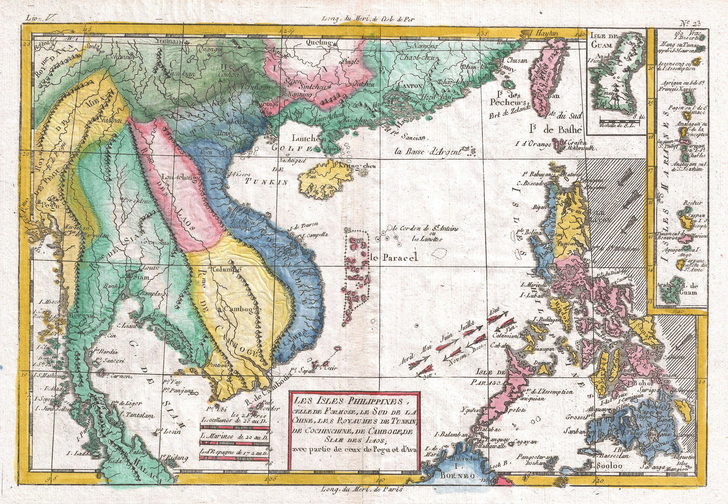
| Rigobert Bonne: Les Isles Philippines
( |
|||||||||||||||||||||||
|---|---|---|---|---|---|---|---|---|---|---|---|---|---|---|---|---|---|---|---|---|---|---|---|
| Họa sĩ |
|
||||||||||||||||||||||
| Tựa đề |
Les Isles Philippines |
||||||||||||||||||||||
| Miêu tả |
English: A fine example of Rigobert Bonne and G. Raynal’s 1780 map of the Southeast Asia and the Philippines. Map corresponds to modern day countries of the Philippines, Vietnam (Tonquin and Chochin), Cambodia (Camboge), Thailand (Siam), Malaysia (Malaca), Taiwan (Formosa) and Laos. Identifies the cities of Tayoun (Taiwan), Manila, Macao, Siam and Bangkok. Furthermore, the Trịnh lords, Nguyễn lords, the Principality of Hà Tiên, Burma, Guam, Northern Mariana Islands, Hainan, Myanmar, Paracel Islands, Yunnan, Guangxi, Guangdong, North Borneo, Yunnan in Qing dynasty, Tonkin and Cochinchina might be identified via the map.
Wind currents and some undersea dangers in the South China Sea. Drawn by R. Bonne for G. Raynal’s Atlas de Toutes les Parties Connues du Globe Terrestre, Dressé pour l'Histoire Philosophique et Politique des Établissemens et du Commerce des Européens dans les Deux Indes . |
||||||||||||||||||||||
| Ngày | 1780 (undated) | ||||||||||||||||||||||
| Kích thước | chiều cao: 9 in (22,8 cm); chiều ngang: 13 in (33 cm) | ||||||||||||||||||||||
| Số lưu trữ |
Geographicus link: Philippines-bonne-1780 |
||||||||||||||||||||||
| Nguồn/Người chụp |
Raynal, G., Atlas de Toutes les Parties Connues du Globe Terrestre, Dressé pour l'Histoire Philosophique et Politique des Établissemens et du Commerce des Européens dans les Deux Indes, 1780.
|
||||||||||||||||||||||
| Giấy phép (Dùng lại tập tin) |
|
||||||||||||||||||||||
Lịch sử tập tin
Nhấn vào ngày/giờ để xem nội dung tập tin tại thời điểm đó.
| Ngày/giờ | Hình xem trước | Kích cỡ | Thành viên | Miêu tả | |
|---|---|---|---|---|---|
| hiện tại | 09:06, ngày 24 tháng 3 năm 2011 | | 2.500×1.731 (1,35 MB) | BotMultichillT | ((subst:User:Multichill/Geographicus |link=http://www.geographicus.com/P/AntiqueMap/Philippines-bonne-1780 |product_name=1780 Raynal and Bonne Map of Southeast Asia and the Philippines |map_title=Les Isles Philippines |description=A fine example of Rigobe |
Trang sử dụng tập tin
Sử dụng tập tin toàn cục
Những wiki sau đang sử dụng tập tin này:
- Trang sử dụng tại en.wikipedia.org
- Trang sử dụng tại fr.wikipedia.org
- Trang sử dụng tại zh.wikipedia.org
Text is available under the CC BY-SA 4.0 license; additional terms may apply.
Images, videos and audio are available under their respective licenses.
Cover photo is available under {{::mainImage.info.license.name || 'Unknown'}} license.
Cover photo is available under {{::mainImage.info.license.name || 'Unknown'}} license.
Credit:
(see original file).
