For faster navigation, this Iframe is preloading the Wikiwand page for
کونگو ناڈو.
கொங்குநாடு
Kongu Nadu |
|---|
| جغرافیائی/تاریخی علاقہ |
 کوئمبتور، کونگ ناڈو خطے کا سب سے بڑا شہر ہے |
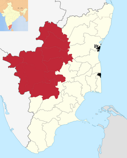
تمل ناڈو میں کونگ ناڈو کی جائے وقوع |
| ملک |  بھارت بھارت |
|---|
| خطہ | جنوبی ہند |
|---|
| حکومت |
|---|
| • مجلس | حکومتِ تمل ناڈو |
|---|
| رقبہ |
|---|
| • کل | 25,864 کلومیٹر2 (9,986 میل مربع) |
|---|
| آبادی (2001)[1] |
|---|
| • کل | 15,700,000 (approx.) |
|---|
| • کثافت | 607/کلومیٹر2 (1,570/میل مربع) |
|---|
| زبانیں |
|---|
| • دفتری | تمل |
|---|
| منطقۂ وقت | بھارتی معیاری وقت (UTC+5:30) |
|---|
| ڈاک اشاریہ رمز | 635-642xxx |
|---|
| گاڑی کی نمبر پلیٹ | TN 27-42, TN 47, TN 52, TN 54, TN 56, TN 66, TN 77, TN 78, TN 88, TN 99 |
|---|
| عظیم ترین شہر | کوئمبتور |
|---|
| خواندگی | 62.61% |
|---|
| Civic agency | حکومتِ تمل ناڈو |
|---|
کونگ ناڈو (Kongu Nadu) بھارت کی جنوبی ریاست تمل ناڈو کے جنوب مغربی حصے کا ایک خطہ ہے۔
|
|---|
| دریا |
- Bhadra
- دریائے بھوانی
- Bhima
- Chalakudy
- Chittar
- گوداوری
- Gurupura
- Kabini
- Kali
- Kallayi
- کاویری
- Koyna
- کرشنا
- Kundali
- Malaprabha
- Manimuthar
- Netravati
- Pachaiyar
- Parambikulam
- سرسوتی
- Savitri
- Sharavati
- Tambaraparani
- تاپتی
- Tunga
- Venna
|
|---|
| علاقے | |
|---|
| چوٹیاں |
- اگستیا
- آناموڈی
- Anginda
- Anjaneri
- Banasura
- Biligirirangana Betta
- Brahmagiri
- Chembra
- Dhodap
- Doddabetta
- Gangamoola
- Harishchandragad
- Kalsubai
- Kemmangundi
- Kudremukh
- Kodachadri
- Kumara Parvata
- Mullayanagiri
- Marunthuvazh Malai
- Ponmudi
- Pushpagiri
- ویتل
- Salher
- Saptashrungi
- Sispara
- Sonsogor
- Tadiandamol
- Taramati
- Vellarimala
- Ranipuram
- Vagamon
|
|---|
| پہاڑیاں |
- Anaimalai Hills
- Biligiriranga Hills
- Cardamom Hills
- نیلاگیری
- Satmala Range
- Selbari Range
- Palni Hills
- Trimbakeshwar Range
|
|---|
| آبشاریں | |
|---|
| ریاستیں | |
|---|
پارک اور
محفوظ پناہ گائیں | |
|---|
| مقامات | |
|---|
| گھاٹیاں |
- Amboli Ghat
- Bhor Ghat
- Tamhini Ghat
- Amba Ghat
- Bhor Road Ghat
- Chorla Ghat
- Goa Gap
- Kasara Road Ghat
- Kumbharli Ghat
- Malshej Ghat
- Naneghat
- Charmadi ghat
- Shiradi ghat
- Bisle ghat
- Sampaje ghat
- Palakkad Gap
- Varandha Ghat
|
|---|
| متعلقہ |
- کیرلا کے پہاڑ
- مہاراشڑ کے پہاڑ
|
|---|
{{bottomLinkPreText}}
{{bottomLinkText}}
This page is based on a Wikipedia article written by
contributors (read/edit).
Text is available under the
CC BY-SA 4.0 license; additional terms may apply.
Images, videos and audio are available under their respective licenses.
{{current.index+1}} of {{items.length}}
Thanks for reporting this video!
This browser is not supported by Wikiwand :(
Wikiwand requires a browser with modern capabilities in order to provide you with the best reading experience.
Please download and use one of the following browsers:
An extension you use may be preventing Wikiwand articles from loading properly.
If you're using HTTPS Everywhere or you're unable to access any article on Wikiwand, please consider switching to HTTPS (https://www.wikiwand.com).
An extension you use may be preventing Wikiwand articles from loading properly.
If you are using an Ad-Blocker, it might have mistakenly blocked our content.
You will need to temporarily disable your Ad-blocker to view this page.
✕
This article was just edited, click to reload
Please click Add in the dialog above
Please click Allow in the top-left corner,
then click Install Now in the dialog
Please click Open in the download dialog,
then click Install
Please click the "Downloads" icon in the Safari toolbar, open the first download in the list,
then click Install
{{::$root.activation.text}}
Follow Us
Don't forget to rate us
Oh no, there's been an error
Please help us solve this error by emailing us at
support@wikiwand.com
Let us know what you've done that caused this error, what browser you're using, and whether you have any special extensions/add-ons installed.
Thank you!


