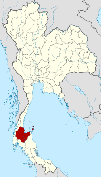
فائل:Thailand Surat Thani locator map.svg

اصل فائل (ایس وی جی فائل، ابعاد 1,052 × 1,849 پکسل، فائل کا حجم: 1.25 MB)
فائل کا تاریخچہ
کسی خاص وقت یا تاریخ میں یہ فائل کیسی نظر آتی تھی، اسے دیکھنے کے لیے اس وقت/تاریخ پر کلک کریں۔
| تاریخ/وقت | تھمب نیل | ابعاد | صارف | تبصرہ | |
|---|---|---|---|---|---|
| رائج الوقت | 16:09، 25 مارچ 2011ء |  | 1,052 × 1,849 (1.25 MB) | Hdamm | Update: new province Bueng Kan |
| 08:29، 23 اپریل 2009ء |  | 1,052 × 1,849 (1.46 MB) | NordNordWest | corr | |
| 18:32، 22 اپریل 2009ء |  | 1,052 × 1,849 (1.45 MB) | NordNordWest | ((Information |Description= ((de|Lagekarte der Provinz Surat Thani, Thailand)) ((en|Locator map of Surat Thani Province, Thailand)) |Source=self-made, using * Thailand location map.svg |Date=22-02-2009 |Author=[[User:N |
روابط
درج ذیل صفحہ اس فائل کو استعمال کر رہا ہے:
فائل کا عالمی استعمال
مندرجہ ذیل ویکیوں میں یہ فائل زیر استعمال ہے:
- ar.wikipedia.org پر استعمال
- be.wikipedia.org پر استعمال
- bg.wikipedia.org پر استعمال
- bo.wikipedia.org پر استعمال
- bpy.wikipedia.org پر استعمال
- cdo.wikipedia.org پر استعمال
- ceb.wikipedia.org پر استعمال
- ckb.wikipedia.org پر استعمال
- de.wikipedia.org پر استعمال
- de.wikivoyage.org پر استعمال
- en.wikipedia.org پر استعمال
- es.wikipedia.org پر استعمال
- fa.wikipedia.org پر استعمال
- fr.wikipedia.org پر استعمال
- gl.wikipedia.org پر استعمال
- hi.wikipedia.org پر استعمال
- hu.wikipedia.org پر استعمال
- id.wikipedia.org پر استعمال
- it.wikipedia.org پر استعمال
- ja.wikipedia.org پر استعمال
- ka.wikipedia.org پر استعمال
- ko.wikipedia.org پر استعمال
- lv.wikipedia.org پر استعمال
- mg.wikipedia.org پر استعمال
- ml.wikipedia.org پر استعمال
- nl.wikipedia.org پر استعمال
- pa.wikipedia.org پر استعمال
- ro.wikipedia.org پر استعمال
- ru.wikipedia.org پر استعمال
- sco.wikipedia.org پر استعمال
- sv.wikipedia.org پر استعمال
- th.wikipedia.org پر استعمال
- tl.wikipedia.org پر استعمال
- tr.wikipedia.org پر استعمال
- uk.wikipedia.org پر استعمال
- vi.wikipedia.org پر استعمال
- www.wikidata.org پر استعمال
- zh-min-nan.wikipedia.org پر استعمال
- zh-yue.wikipedia.org پر استعمال
- zh.wikipedia.org پر استعمال
Text is available under the CC BY-SA 4.0 license; additional terms may apply.
Images, videos and audio are available under their respective licenses.


