Фліт-стріт
Матеріал з Вікіпедії — вільної енциклопедії.
| Флотська вулиця | |
|---|---|
| англ. Fleet Street | |
 | |
| Населений пункт | Лондон |
| Район | Сіті |
| Історичні відомості | |
| Назва на честь | Флотської річки[en] |
| Загальні відомості | |
| Протяжність | 0,5 км[1] |
| Координати початку | 51°30′49″ пн. ш. 0°06′41″ зх. д. / 51.5137167° пн. ш. 0.1116222° зх. д. |
| Координати | 51°30′51″ пн. ш. 0°06′29″ зх. д. / 51.5142194° пн. ш. 0.1080806° зх. д. |
| Координати кінця | 51°30′50″ пн. ш. 0°06′16″ зх. д. / 51.5141583° пн. ш. 0.1044556° зх. д. |
| Поштові індекси | EC4 |
| Транспорт | |
| Найближчі станції метро | Темпл |
| З'єднання | Стренд Ludgate Hilld Chancery Laned Bouverie Streetd Fetter Laned Shoe Laned New Bridge Streetd Ludgate Circusd Farringdon Streetd Bride Laned Middle Temple Laned Inner Temple Laned Bell Yardd Whitefriars Streetd Bolt Courtd Salisbury Courtd Pleydell Courtd Wine Office Courtd Clifford's Inn Passaged Hind Courtd |
| Інфраструктура | |
| Будівлі | Банки: Барклайс, C. Hoare & Co., HSBC, Bouverie House, Галіфакс, Ґолдман Сакс Церкви: Темпл, Сент-Брідс[en] |
| Зовнішні посилання | |
| У проєкті OpenStreetMap | ↑51800 ·R (Лондонське Сіті, Вестмінстер) |
| Мапа | |
 | |
| | |
Флотська вулиця (англ. Fleet Street) — вулиця в лондонському Сіті, що йде із заходу на схід від Стренда до площі Лудгейт-Цирку[en].
У Середні століття прилеглою територією володіли тамплієри (див. Темпл). Згодом тут розмістилися головні судові установи Великої Британії, а околиці заполонили суддівські чиновники і адвокати. Нарешті, з XVI століття на Фліт-стріт стали з'являтися офіси основних лондонських газет, а пізніше — і інформаційних агентств (наприклад, «Рейтер»). Хоча багато ЗМІ останнім часом переїхали в інші райони, за Флотською вулицею міцно закріпилася репутація цитаделі британської преси.
Назва вулиці походить від найбільшої, тепер підземної, притоки Темзи в Лондоні — річки Фліт[en].
-
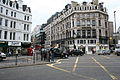
 Флотська вулиця.
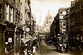
1890 -
 Міський дракон на даху Темпл Бару
 -
 Вулиця під час коронації. 1953
 -
 Будівля редакції газети «Дейлі експрес»
 -
 Дзвіниця церкви
Сент-Брідс -
 Площа Ладгейт
 -

-
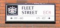 Вулична табличка


- ↑ 3, Fleet Street to 100, Fleet Street. Google Maps. Процитовано 28 грудня 2015.
- Farewell, Fleet Street. Bill Hagerty, BBC News Online. 14 June 2005.
- Fleet Street's finest. Christopher Hitchens, The Guardian Review. 3 December 2005.
|
Text is available under the CC BY-SA 4.0 license; additional terms may apply.
Images, videos and audio are available under their respective licenses.
Cover photo is available under {{::mainImage.info.license.name || 'Unknown'}} license.
Cover photo is available under {{::mainImage.info.license.name || 'Unknown'}} license.
Credit:
(see original file).
