Файл:Lage des Ruhrgebiets.png
Матеріал з Вікіпедії — вільної енциклопедії.
Нема версії з більшою роздільністю.
Lage_des_Ruhrgebiets.png (176 × 234 пікселів, розмір файлу: 5 КБ, MIME-тип: image/png)
| Відомості про цей файл містяться на Вікісховищі — централізованому сховищі вільних файлів мультимедіа для використання в проектах Фонду Вікімедіа. |
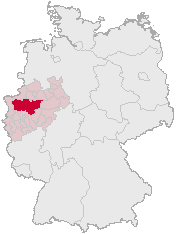
The map shows the position of the Ruhr Area in Germany on basis of http://opengeodb.org/wiki/OpenGeoDB and changes of de:Benutzer:Geograv

|
Дозволяється копіювати, розповсюджувати та/або модифікувати цей документ на умовах ліцензії GNU FDL версії 1.2 або більш пізньої, виданої Фондом вільного програмного забезпечення, без незмінних розділів, без текстів, які розміщені на першій та останній обкладинці. Копія ліцензії знаходиться у розділі GNU Free Documentation License. |
| Цей файл ліцензований на умовах ліцензії Creative Commons Attribution-Share Alike 3.0 Unported | ||
| ||
| Цей шаблон ліцензування був доданий до файлу в рамках оновлення ліцензії GFDL. |
Please list pages which use this map (or other versions of it) here:
Bitte listen Sie hier Seiten auf, die diese Karte (bzw. andere Versionen von ihr) nutzen hier:
Історія файлу
Клацніть на дату/час, щоб переглянути, як тоді виглядав файл.
| Дата/час | Мініатюра | Розмір об'єкта | Користувач | Коментар | |
|---|---|---|---|---|---|
| поточний | 09:03, 28 січня 2005 | | 176 × 234 (5 КБ) | Threedots | Position of the Ruhr area in Germany ((GFDL)) |
Використання файлу
Така сторінка використовує цей файл:
Глобальне використання файлу
Цей файл використовують такі інші вікі:
- Використання в ar.wikipedia.org
- Використання в arz.wikipedia.org
- Використання в be.wikipedia.org
- Використання в cs.wikipedia.org
- Використання в da.wikipedia.org
- Використання в de.wiktionary.org
- Використання в el.wikipedia.org
- Використання в eo.wikipedia.org
- Використання в es.wikipedia.org
- Використання в et.wikipedia.org
- Використання в fr.wikipedia.org
- Використання в ja.wikipedia.org
- Використання в ko.wikipedia.org
- Використання в ky.wikipedia.org
- Використання в la.wikipedia.org
- Використання в lmo.wikipedia.org
- Використання в mr.wikipedia.org
- Використання в nl.wikipedia.org
- Використання в nn.wikipedia.org
- Використання в no.wikipedia.org
- Використання в pl.wikipedia.org
- Використання в ro.wikipedia.org
- Використання в ru.wikipedia.org
- Використання в sk.wikipedia.org
- Використання в sv.wikipedia.org
- Використання в vi.wikipedia.org
- Використання в zh.wikipedia.org
Метадані
Text is available under the CC BY-SA 4.0 license; additional terms may apply.
Images, videos and audio are available under their respective licenses.
Cover photo is available under {{::mainImage.info.license.name || 'Unknown'}} license.
Cover photo is available under {{::mainImage.info.license.name || 'Unknown'}} license.
Credit:
(see original file).
