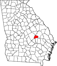
Тройтлен (округ, Джорджія)
Матеріал з Вікіпедії — вільної енциклопедії.
Координати: 32°24′00″ пн. ш. 82°34′12″ зх. д. / 32.40000000002777369445539080° пн. ш. 82.57000000002777540° зх. д.
| Округ Тройтлен, Джорджія | |
 На мапі штату Джорджія | |
 Розташування штату Джорджія на мапі США | |
| Заснований | 21 серпня 1917 |
|---|---|
| Центр | Сопертон |
| Найбільше місто | Сопертон |
| Площа - Загальна - Суходолу - Водойм |
202 кв. миль (523 км²) 199 кв. миль (515 км²) 3 кв. миль (8 км²), 1.49 % |
| Населення - (2020) - Густота |
6406 32/кв. миль (12,2/км²) |
| Вебсайт | treutlencountygov.com |

| |
Округ Тройтлен (англ. Treutlen County) — округ (графство) у штаті Джорджія, США. Ідентифікатор округу 13283.
Округ утворений 1917 року.
| Історія переписів | |||
|---|---|---|---|
| Перепис | Населення | Зміна в % | |
| 1920 | 7664 | — | |
| 1930 | 7488 | −2.3% | |
| 1940 | 7632 | 1.9% | |
| 1950 | 6522 | −14.5% | |
| 1960 | 5874 | −9.9% | |
| 1970 | 5647 | −3.9% | |
| 1980 | 6087 | 7.8% | |
| 1990 | 5994 | −1.5% | |
| 2000 | 6854 | 14.3% | |
| 2010 | 6885 | 0.5% | |
| 2020 | 6406 | −7.0% | |
| U.S. Decennial Census[1] 1790-1960[2] 1900-1990[3] 1990-2000[4] 2010-2013[5] | |||
За даними перепису 2000 року[6] загальне населення округу становило 6854 осіб, зокрема міського населення було 3036, а сільського — 3818. Серед мешканців округу чоловіків було 3404, а жінок — 3450. В окрузі було 2531 домогосподарство, 1825 родин, які мешкали в 2865 будинках. Середній розмір родини становив 3,05.
Віковий розподіл населення поданий у таблиці:
| Стать | До 15 років | 15-21 | 22-29 | 30-39 | 40-49 | 50-65 | 65-85 | Понад 85 |
|---|---|---|---|---|---|---|---|---|
| Чоловіки | 746 | 505 | 412 | 457 | 446 | 482 | 333 | 23 |
| Жінки | 716 | 348 | 375 | 418 | 498 | 543 | 463 | 89 |
- Емануель — північний схід
- Монтгомері — південний схід
- Вілер — південний захід
- Лоренс — захід
- Джонсон — північний захід
- ↑ U.S. Decennial Census. United States Census Bureau. Процитовано 26 червня 2014.
- ↑ Historical Census Browser. University of Virginia Library. Архів оригіналу за 11 серпня 2012. Процитовано 26 червня 2014.
- ↑ Population of Counties by Decennial Census: 1900 to 1990. United States Census Bureau. Процитовано 26 червня 2014.
- ↑ Census 2000 PHC-T-4. Ranking Tables for Counties: 1990 and 2000 (PDF). United States Census Bureau. Процитовано 26 червня 2014.
- ↑ State & County QuickFacts. United States Census Bureau. Архів оригіналу за 31 січня 2016. Процитовано 26 червня 2014.(англ.) Наведено за англійською вікіпедією.
- ↑ American FactFinder. Бюро перепису населення США. Архів оригіналу за 26 лютого 2012. Процитовано 31 січня 2008.
| Це незавершена стаття з географії США. Ви можете допомогти проєкту, виправивши або дописавши її. |
Text is available under the CC BY-SA 4.0 license; additional terms may apply.
Images, videos and audio are available under their respective licenses.

