Тейнінь (провінція)
Матеріал з Вікіпедії — вільної енциклопедії.
| Тейнінь | |||||||||||||
|---|---|---|---|---|---|---|---|---|---|---|---|---|---|
|
в'єт. Tây Ninh | |||||||||||||
| |||||||||||||

| |||||||||||||
| Адм. центр | Тейнінь | ||||||||||||
| Країна | |||||||||||||
| |||||||||||||
| Офіційна мова | в'єтнамська | ||||||||||||
| Населення | |||||||||||||
| - повне | 1 066 513 (2009) (36) | ||||||||||||
| - густота | 263,37 осіб/км² (32) | ||||||||||||
| Етнікон | в'єтнамці | ||||||||||||
| Площа | |||||||||||||
| - повна | 4049 км² (35) | ||||||||||||
| Висота | |||||||||||||
| - максимальна | 20 м | ||||||||||||
| - мінімальна | 20 м | ||||||||||||
| Вебсайт | tayninh.gov.vn | ||||||||||||
| Код ISO 3166-2 | VN-37 | ||||||||||||

| |||||||||||||

| |||||||||||||
| |||||||||||||
Тейнінь (в'єт. Tây Ninh) — провінція на південному заході В'єтнаму. Площа становить 4049 км²; населення за даними перепису 2009 року — 1 066 513 жителів[1]. Щільність населення — 263,37 осіб/км². Адміністративний центр — містечко місцевого значення Тейнінь. В адміністративному відношенні поділяється на 1 містечко місцевого значення (Тейнінь) і 8 повітів.
На території провінції розташована унікальна гора Чорна Діва
Під час Війни у В'єтнамі біля гори Чорна Діва відбулася Новорічна битва 1968 року.
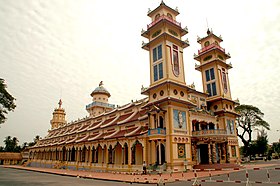
Батьківщина релігії каодай.
У 2009 році населення провінції становило 1 066 513 осіб (перепис), з них 530 648 (49,76 %) чоловіки і 535 865 (50,24 %) жінки, 900 286 (84,41 %) сільські жителі і 166 227 (15,59 %) жителі міст[1].
Національній склад населення (за даними перепису 2009 року): в'єтнамці 1 050 376 осіб (98,49 %), кхмери 7 578 осіб (0,71 %), інші 8 559 осіб (0,80 %)[2].
| Біньфиок | ||

|
Біньзионг | |
| Лонган | Хошимін |
- ↑ а б Table 1: Population by urban/rural residence, sex, socio-economic region and province/city, 1/4/2009. Center for Statistical Information Technology N°I, GSO, Department for Population and Labour Statistics (в'єтн.)(англ.)
- ↑ Table 5: Population by urban/rural residence, sex, ethnic group, socio-economic region and province/city, 1/4/2009. Center for Statistical Information Technology N°I, GSO, Department for Population and Labour Statistics (в'єтн.)(англ.)
- Офіційний сайт (в'єтн.)
| Це незавершена стаття з географії В'єтнаму. Ви можете допомогти проєкту, виправивши або дописавши її. |
| Регіони (8) |
| |
|---|---|---|
| Міста центрального підпорядкування (5) | ||
| Провінції (58) |
| |
Text is available under the CC BY-SA 4.0 license; additional terms may apply.
Images, videos and audio are available under their respective licenses.


