Зейдбрук (Гронінген)
Матеріал з Вікіпедії — вільної енциклопедії.
| Село
Зейдбрук

Координати 53°09′45″ пн. ш. 6°51′38″ сх. д. / 53.16250000002777654° пн. ш. 6.86060000002777759° сх. д.Координати: 53°09′45″ пн. ш. 6°51′38″ сх. д. / 53.16250000002777654° пн. ш. 6.86060000002777759° сх. д.
|
_wapen.svg)


Зейдбрук (нід. Zuidbroek, нід. вимова: [zœydˈbruk]) — село в нідерландській провінції Гронінген. Входить до муніципалітету Мідден-Гронінген.
Його площа становить 17,28км², а населення станом на 2021 рік складало 3 575 осіб.
До 1965 року мало статус окремого муніципалітету.
-
 Залізнична станція
 -
 Канал у селі
 -
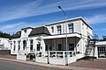
 Будівля колишнього суду
 -
 Реформистська церква


,_Sint-Pitertsjerke_(2022).jpg)
Населені пункти муніципалітету Мідден-Гронінген | |
|---|---|
| Міста | |
| Села |
|
| Селища | |
| Географія та географічні карти | |
|---|---|
| Нормативний контроль |
| Це незавершена стаття з географії Нідерландів. Ви можете допомогти проєкту, виправивши або дописавши її. |
Text is available under the CC BY-SA 4.0 license; additional terms may apply.
Images, videos and audio are available under their respective licenses.
Cover photo is available under {{::mainImage.info.license.name || 'Unknown'}} license.
Cover photo is available under {{::mainImage.info.license.name || 'Unknown'}} license.
Credit:
(see original file).
