Енгелберт (Нідерланди)
Матеріал з Вікіпедії — вільної енциклопедії.
| Село
Енгелберт
 Координати 53°12′32″ пн. ш. 6°38′47″ сх. д. / 53.20888900002777433° пн. ш. 6.64638900002777788° сх. д.Координати: 53°12′32″ пн. ш. 6°38′47″ сх. д. / 53.20888900002777433° пн. ш. 6.64638900002777788° сх. д.
|


Енгелберт (нід. Engelbert) — село в нідерландській провінції Гронінген. Входить до муніципалітету Гронінген.
Його площа становить 3,36км², а населення станом на 2021 рік складало 890 осіб.
Перша згадка про населений пункт датується 1323 роком.
-
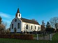 Церква в Енгелберті
 -
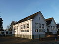 Школа
Школа -
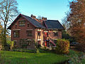 Будинок почту
 -
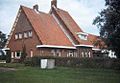 Будівля колишньої залізничної станції


.jpg)

Населені пункти муніципалітету Гронінген | |
|---|---|
| Міста | |
| Села | |
| Селища |
|
| Це незавершена стаття з географії Нідерландів. Ви можете допомогти проєкту, виправивши або дописавши її. |
Text is available under the CC BY-SA 4.0 license; additional terms may apply.
Images, videos and audio are available under their respective licenses.
Cover photo is available under {{::mainImage.info.license.name || 'Unknown'}} license.
Cover photo is available under {{::mainImage.info.license.name || 'Unknown'}} license.
Credit:
(see original file).
