ھۆججەت:Location of Gongliu within Xinjiang (China).png
بۇ ئالدىن كۆزىتىشنىڭ چوڭلۇقى: 789 × 600 پىكسېل. باشقا چوڭلۇقى: 316 × 240 پىكسېل | 631 × 480 پىكسېل | 960 × 730 پىكسېل.
ئەسلى ھۆججەت (960 × 730 پىكسېل، ھۆججەت چوڭلۇقى: 164 KB، MIME تىپى: image/png)
ئۈزۈندە
| چۈشەندۈرۈش |
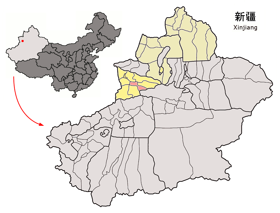
Location of Gongliu County (pink) and Ili Prefecture (yellow: subdivisions under direct administration of Ili Prefecture, ecru: subdivisions under administration of Tacheng and Altay Prefectures) within Xinjiang autonomous region of China Map drawn in september 2007 using various sources, mainly : |
| چېسلا | |
| مەنبە | ئۆز ئەسىرىم |
| يازغۇچى | Croquant |
ئىجازەت
I, the copyright holder of this work, hereby publish it under the following license:
This file is licensed under the Creative Commons Attribution 3.0 Unported license.
- سىز ئەركىن:
- بەھىرلەش – to copy, distribute and transmit the work
- ئۆزگەرتىش – ئىجادىي ئەسەر
- تۆۋەندىكى شەرتلەرگە چوقۇم ئەمەل قىلىڭ:
- ئىمزا – You must give appropriate credit, provide a link to the license, and indicate if changes were made. You may do so in any reasonable manner, but not in any way that suggests the licensor endorses you or your use.
ھۆججەت تارىخى
چېسلا/ۋاقىت چېكىلسە ئەينى ۋاقىتتا كۆرۈلگەن ھۆججەتنى كۆرسىتىدۇ.
| چېسلا/ۋاقىت | كىچىك سۈرەت | ئۆلچەم | ئىشلەتكۈچى | ئىزاھات | |
|---|---|---|---|---|---|
| نۆۋەتتىكى | 17:44, 7 سىنتەبىر 2007 | | 960 × 730 (164 KB) | Croquant | == Summary == ((Information |Description=Location of Gongliu County (pink) and Ili Prefecture (yellow: subdivisions under direct administration of Ili Prefecture, ecru: subdivisions under administration of Tacheng and Altay Prefectures) within Xinjiang au |
ھۆججەت ئىشلىتىلىشى
تۆۋەندىكى بەت بۇ ھۆججەتنى ئىشلىتىدۇ:
ئورتاق ھۆججەت ئىشلىتىلىشى
تۆۋەندىكى باشقا ۋىكىلار بۇ ھۆججەتنى ئىشلىتىدۇ:
- de.wikipedia.org دىكى ئىشلىتىشى
- es.wikipedia.org دىكى ئىشلىتىشى
- fr.wikipedia.org دىكى ئىشلىتىشى
- ja.wikipedia.org دىكى ئىشلىتىشى
- ko.wikipedia.org دىكى ئىشلىتىشى
- no.wikipedia.org دىكى ئىشلىتىشى
- pt.wikipedia.org دىكى ئىشلىتىشى
- ru.wikipedia.org دىكى ئىشلىتىشى
- sv.wikipedia.org دىكى ئىشلىتىشى
- tr.wikipedia.org دىكى ئىشلىتىشى
- uk.wikipedia.org دىكى ئىشلىتىشى
- vi.wikipedia.org دىكى ئىشلىتىشى
- www.wikidata.org دىكى ئىشلىتىشى
- zh-yue.wikipedia.org دىكى ئىشلىتىشى
Text is available under the CC BY-SA 4.0 license; additional terms may apply.
Images, videos and audio are available under their respective licenses.
Cover photo is available under {{::mainImage.info.license.name || 'Unknown'}} license.
Cover photo is available under {{::mainImage.info.license.name || 'Unknown'}} license.
Credit:
(see original file).

.png)