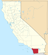
San Diego County, California
San Diego County | |||
|---|---|---|---|
County | |||
| County of San Diego | |||
|
Images, from top down, left to right: F/A-18 Hornet flying over San Diego, Mission San Diego de Alcalá, San Diego State University's Hepner Hall, Hotel del Coronado's main building, Torrey Pines State Natural Reserve, Jacumba Mountains | |||
| |||
 Interactive map of San Diego County | |||
 Location in the state of California | |||
| Coordinates: 33°01′N 116°46′W / 33.02°N 116.77°W | |||
| Country | United States | ||
| State | California | ||
| Formed | February 18, 1850[1] | ||
| Named for | San Diego de Alcalá | ||
| County seat | San Diego | ||
| Largest city | San Diego | ||
| Government | |||
| • Type | Council–CEO | ||
| • Body | Board of Supervisors | ||
| • Chair | Nora Vargas (D) | ||
| • Vice Chair | Terra Lawson-Remer (D) | ||
| • Board of Supervisors[3] | Supervisors
| ||
| • Chief Administrative Officer | Helen Robbins-Meyer[2] | ||
| • District Attorney | Summer Stephan | ||
| Area | |||
| • Total | 4,260.9 sq mi (11,036 km2) | ||
| • Land | 3,942 sq mi (10,210 km2) | ||
| • Water | 319 sq mi (830 km2) | ||
| Highest elevation | 6,536 ft (1,992 m) | ||
| Population (April 1, 2020) | |||
| • Total | 3,298,634 | ||
| • Density | 837/sq mi (323/km2) | ||
| Time zone | UTC–8 (Pacific Time Zone) | ||
| • Summer (DST) | UTC–7 (Pacific Daylight Time) | ||
| Area codes | 442/760, 619/858, and 949 | ||
| FIPS code | 06-073 | ||
| GDP | $225 billion[6] | ||
| GDP per capita | $68,457 | ||
| Website | www | ||
San Diego County, California ni msumba uchoko panji nkhalwe (county pachingelezi) iyo ikusangika mu boma likulu la California mu charu cha United States of America. Boma likulu la California lina tumisumba 58 mukwati mwake (counties).
Ukaboni
- ↑ "Chronology". California State Association of Counties. Retrieved February 6, 2015.
- ↑ "Chief Administrative Officer". County of San Diego. Retrieved January 31, 2015.
- ↑ "Board of Supervisors". County of San Diego. Retrieved January 12, 2015.
- ↑ "Home". sangis.org.
- ↑ "Hot Springs Mountain". Peakbagger.com. Retrieved January 31, 2015.
- ↑ "GDP by County – U.S. Bureau of Economic Analysis (BEA)". Bea.gov. Retrieved December 12, 2019.
Alameda • Alpine • Amador • Butte • Calaveras • Colusa • Contra Costa • Del Norte • El Dorado • Fresno • Glenn • Humboldt • Imperial • Kern • Kings • Lake • Lassen • Los Angeles • Madera • Marin • Mariposa • Mendocino • Merced • Modoc • Mono • Monterey • Napa • Nevada • Orange • Placer • Plumas • Riverside • Sacramento • San Benito • San Bernardin • San Diego • San Francisco • San Joaquin • San Luis Obispo • San Mateo • Santa Barbara • Santa Clara • Santa Cruz • Shasta • Sierra • Siskiyou • Solano • Sonoma • Stanislaus • Sutter • Tehama • Trinity • Tulare • Tuolumne • Ventura • Yolo • Yuba
Text is available under the CC BY-SA 4.0 license; additional terms may apply.
Images, videos and audio are available under their respective licenses.


