Файл:Canada2.A2002165.1940.250m.jpg
Алдан карауның зурлыгы: 461 × 599 нокта. Башка ачыклык: 184 × 240 нокта | 369 × 480 нокта | 591 × 768 нокта | 788 × 1024 нокта | 1575 × 2048 нокта | 4000 × 5200 нокта.
Төп файл (4000 × 5200 нокта, файл зурлыгы: 2,83 Мб, MIME төре: image/jpeg)
Тасвирлама
| Тасвир |
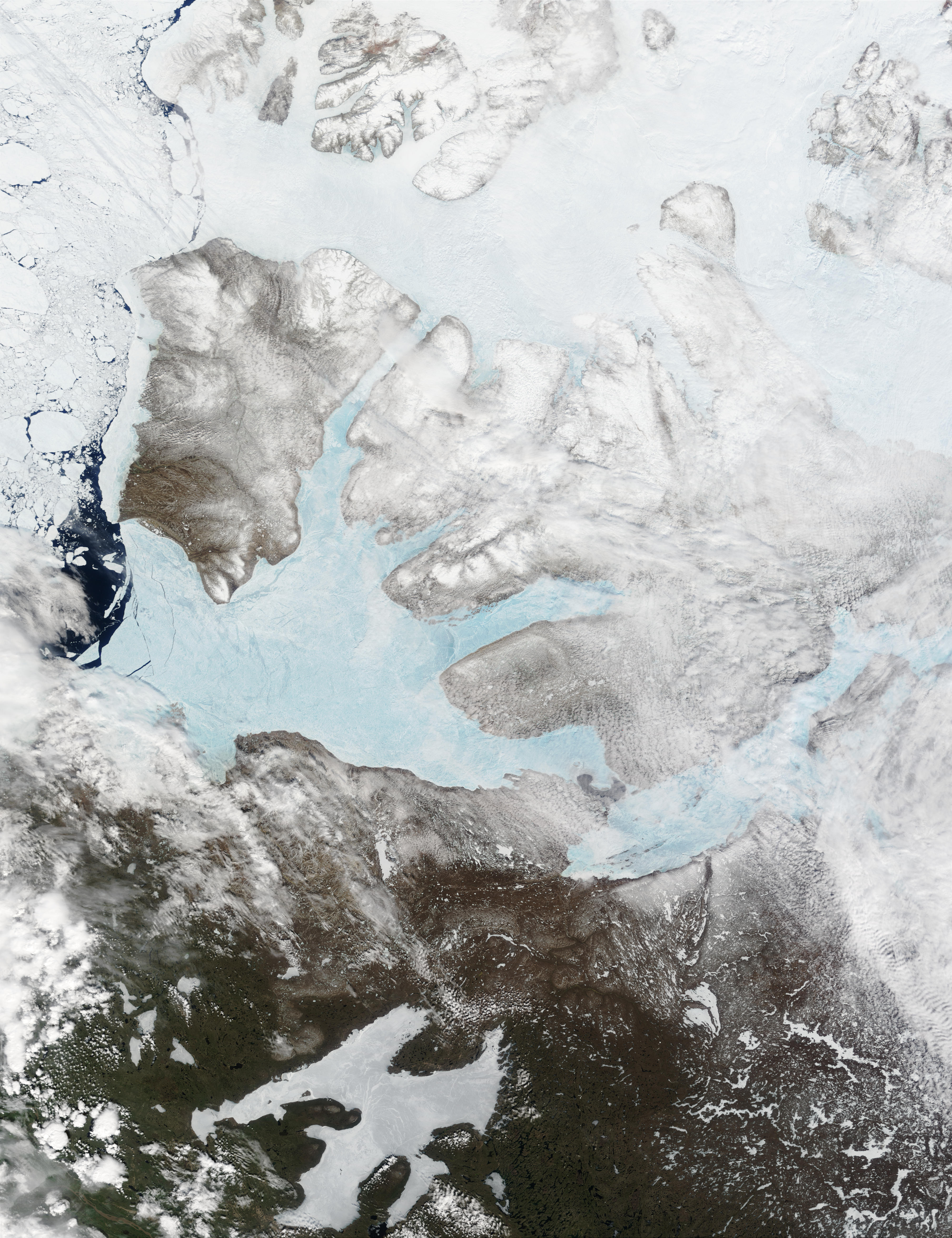
English: These Moderate resolution Imaging Spectroradiometer Images from June 14 and 16, 2002, show Banks Island (upper left) and Victoria Island (to the southeast) in the Arctic Ocean off northwest Canada. Left of center in each image is Amundsen Gulf, looking bright blue as this arm of the Beaufort Sea (at the southern end of the Arctic Ocean) begins to thaw. At the bottom of the images, the tundra of the Northwest Territories (left) and the Nunavut (right) Provinces of Canada is beginning to lose its winter snow cover. At bottom center of the portrait oriented image is Great Bear lake--still frozen. |
| Дата | June 14 and 16, 2002 |
| Чыганак | http://visibleearth.nasa.gov/view_rec.php?id=3342 |
| Автор | Jacques Descloitres, MODIS Land Rapid Response Team, NASA/GSFC |
Лицензияләү
| Этот файл находится в общественном достоянии (англ. public domain), так как он был создан NASA (Национальным управлением по аэронавтике и исследованию космического пространства). Политика авторского права NASA гласит, что «Материал NASA не защищается авторским правом, если не указано иное». (См. Template:PD-USGov, страницу политики авторского права NASA или политику использования изображений JPL.) | ||
 |
Предупреждения:
|
Файл тарихы
Файлның нинди булганлыгын күрү өчен «дата/вакыт» дигәненә басыгыз.
| Дата/вакыт | Кече рәсем | Үлчәмнәре | Кулланучы | Искәрмә | |
|---|---|---|---|---|---|
| агымдагы | 20 авг 2008, 17:59 | | 4000 × 5200 (2,83 Мб) | Ando228 | ((Information |Description=((en|1=These Moderate resolution Imaging Spectroradiometer Images from June 14 and 16, 2002, show Banks Island (upper left) and Victoria Island (to the southeast) in the Arctic Ocean off northwest Canada. Left of center in each |
Файлны куллану
Әлеге файл киләсе битне куллана:
Файлның гомуми кулланышы
Әлеге файл аста бирелгән викиларда куллана:
- af.wikipedia.org проектында куллану
- ar.wikipedia.org проектында куллану
- ast.wikipedia.org проектында куллану
- az.wikipedia.org проектында куллану
- be.wikipedia.org проектында куллану
- bg.wikipedia.org проектында куллану
- bn.wikipedia.org проектында куллану
- ca.wikipedia.org проектында куллану
- ceb.wikipedia.org проектында куллану
- cy.wikipedia.org проектында куллану
- da.wikipedia.org проектында куллану
- de.wikivoyage.org проектында куллану
- diq.wikipedia.org проектында куллану
- en.wikipedia.org проектында куллану
- es.wikipedia.org проектында куллану
- eu.wikipedia.org проектында куллану
- fa.wikipedia.org проектында куллану
- fi.wikipedia.org проектында куллану
- fr.wikipedia.org проектында куллану
- fr.wikivoyage.org проектында куллану
- fy.wikipedia.org проектында куллану
- ga.wikipedia.org проектында куллану
- gl.wikipedia.org проектында куллану
- he.wikipedia.org проектында куллану
- hu.wikipedia.org проектында куллану
- hy.wikipedia.org проектында куллану
- ilo.wikipedia.org проектында куллану
- is.wikipedia.org проектында куллану
- it.wikipedia.org проектында куллану
- ja.wikipedia.org проектында куллану
- ko.wikipedia.org проектында куллану
- ku.wikipedia.org проектында куллану
- la.wikipedia.org проектында куллану
- lv.wikipedia.org проектында куллану
- ml.wikipedia.org проектында куллану
- mzn.wikipedia.org проектында куллану
- nl.wikipedia.org проектында куллану
- nn.wikipedia.org проектында куллану
Бу файлның гомуми кулланышын карау.
Метабирелмәләр
Text is available under the CC BY-SA 4.0 license; additional terms may apply.
Images, videos and audio are available under their respective licenses.
Cover photo is available under {{::mainImage.info.license.name || 'Unknown'}} license.
Cover photo is available under {{::mainImage.info.license.name || 'Unknown'}} license.
Credit:
(see original file).
