Salur, Sorgun
| Salur | |
|---|---|
 | |
 Yozgat | |
| Ülke | |
| İl | Yozgat |
| İlçe | Sorgun |
| Coğrafi bölge | İç Anadolu Bölgesi |
| Rakım | 1150 m |
| Nüfus (2000) | |
| • Toplam | 391 |
| Zaman dilimi | UTC+03.00 (TSİ) |
| İl alan kodu | 0354 |
| Posta kodu | 66700 |
Resmî site [1] | |
Salur, Yozgat ilinin Sorgun ilçesine bağlı bir köydür.
Coğrafya
[değiştir | kaynağı değiştir]Yozgat iline 57 km, Sorgun ilçesine 24 km uzaklıktadır.
Nüfus
[değiştir | kaynağı değiştir]| Yıllara göre köy nüfus verileri | |
|---|---|
| 2007 | 398 |
| 2000 | 269 |
| 1997 | 391 |
Resim galerisi
[değiştir | kaynağı değiştir]-
 2008'de Salur
 -
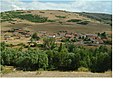 2010'da Salur


Dış bağlantılar
[değiştir | kaynağı değiştir]Kaynakça
[değiştir | kaynağı değiştir]- ^ a b "SALUR KÖYÜ". YerelNet.org.tr. 4 Mart 2016 tarihinde kaynağından arşivlendi. Erişim tarihi: 19 Ağustos 2015.
Text is available under the CC BY-SA 4.0 license; additional terms may apply.
Images, videos and audio are available under their respective licenses.
Cover photo is available under {{::mainImage.info.license.name || 'Unknown'}} license.
Cover photo is available under {{::mainImage.info.license.name || 'Unknown'}} license.
Credit:
(see original file).
