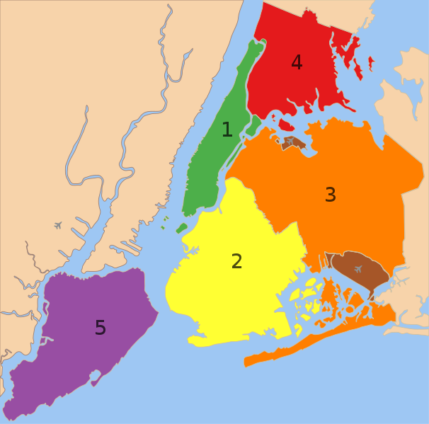
Dosya:5 Boroughs Labels New York City Map.svg

Tam çözünürlük (SVG dosyası, sözde 2.000 × 1.978 piksel, dosya boyutu: 138 KB)
Dosya geçmişi
Dosyanın herhangi bir zamandaki hâli için ilgili tarih/saat kısmına tıklayın.
| Tarih/Saat | Küçük resim | Boyutlar | Kullanıcı | Yorum | |
|---|---|---|---|---|---|
| güncel | 22.57, 9 Şubat 2023 |  | 2.000 × 1.978 (138 KB) | Nafsadh | Reverted to version as of 18:55, 26 October 2014 (UTC) Intention to not add English label to the svg itself was to keep it mostly language independent and not having to be subject to svg text rendering issues. |
| 08.18, 18 Ocak 2020 |  | 2.000 × 1.978 (150 KB) | Mccbala | Added captions to all 5 boroughs and 2 airports. | |
| 18.55, 26 Ekim 2014 |  | 2.000 × 1.978 (138 KB) | Nafsadh | Cleanup SVG | |
| 10.07, 26 Ekim 2014 |  | 2.000 × 1.978 (138 KB) | Nafsadh | ((Information |Description =((en|1=5 boroughs)) |Source =File:5_Boroughs_Labels_New_York_City_Map_Julius_Schorzman.png |Author =Julius Schorzman |Date = |Permission = |other_versions = )) |
Dosya kullanımı
Bu görüntü dosyasına bağlantısı olan sayfalar:
Küresel dosya kullanımı
Aşağıdaki diğer vikiler bu dosyayı kullanır:
- arz.wikipedia.org üzerinde kullanımı
- az.wikipedia.org üzerinde kullanımı
- bn.wikipedia.org üzerinde kullanımı
- br.wikipedia.org üzerinde kullanımı
- bs.wikipedia.org üzerinde kullanımı
- cs.wikipedia.org üzerinde kullanımı
- de.wikipedia.org üzerinde kullanımı
- eml.wikipedia.org üzerinde kullanımı
- en.wikipedia.org üzerinde kullanımı
- Municipality
- Administrative divisions of New York (state)
- New York City
- Demographics of New York City
- Boroughs of New York City
- Neighborhoods in New York City
- User:Nafsadh
- User:Nafsadh/Gallery
- User:Saurabh Mittra/Gather lists/18958 – Saurabh's Articles Collection
- User:Andrewa/New York (overview)
- List of African American newspapers in New York
- User:DoctorShmullus/sandbox2
- User:Chronus/sandbox
- en.wikiquote.org üzerinde kullanımı
- fa.wikipedia.org üzerinde kullanımı
- fr.wikipedia.org üzerinde kullanımı
- glk.wikipedia.org üzerinde kullanımı
- hy.wikipedia.org üzerinde kullanımı
- it.wikipedia.org üzerinde kullanımı
- ku.wikipedia.org üzerinde kullanımı
- la.wikipedia.org üzerinde kullanımı
- lfn.wikipedia.org üzerinde kullanımı
- lld.wikipedia.org üzerinde kullanımı
- mt.wikipedia.org üzerinde kullanımı
- no.wikipedia.org üzerinde kullanımı
- nso.wikipedia.org üzerinde kullanımı
- oc.wikipedia.org üzerinde kullanımı
Bu dosyanın daha fazla küresel kullanımını görüntüle.
Meta veri
Text is available under the CC BY-SA 4.0 license; additional terms may apply.
Images, videos and audio are available under their respective licenses.


