For faster navigation, this Iframe is preloading the Wikiwand page for Talaksan:Médio-assyrien.png.

Talaksan:Médio-assyrien.png
Buong resolusyon((883 × 724 pixel, laki ng talaksan: 724 KB, uri ng MIME: image/png))

Paglalarawan
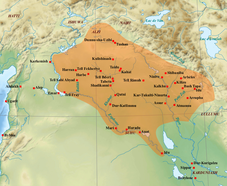
English: Map of the medio-assyrian kingdom (End of the 13th- beginning of the 11th centuries BC).
Français : Carte des limites approximatives du royaume médio-assyrien à son apogée (Fin XIIIe-début XIe siècles av. J.-C.). Sources utilisées : Bertrand Lafont, Aline Tenu, Philippe Clancier et Francis Joannès, Mésopotamie : De Gilgamesh à Artaban (3300-120 av. J.-C.), Paris, Belin, coll. « Mondes anciens », 2017, p. 531 ; John Nicholas Postgate, Bronze Age Bureaucracy: Writing and the Practice of Government in Assyria, Cambridge, Cambridge University Press, 2013, p. 31 ; Martin Sauvage (dir.), Atlas historique du Proche-Orient ancien, Paris, Les Belles Lettres, 2020, p. 102.
Petsa (UTC)
Pinanggalingan
May-akda
Iba pang mga bersyon File:Medio assyrien.svg


This is a retouched picture, which means that it has been digitally altered from its original version. Modifications: Ajout des limites du royaume médio-assyrien et des villes et sites archéologiques principaux.. The original can be viewed here: Near East topographic map-blank.svg. Modifications made by Zunkir.

Ako, na may karapatang-ari ng akdang ito, ang naglalathala nito alinsunod sa ilalim ng sumusunod na mga lisensya:
w:tl:Creative Commons
atribusyon share alike
Ang talaksang ito ay nakalisensiya sa ilalim ng lisensiyang Creative Commons Atribusyon-Pagpapamahaging Magkatulad 3.0 Walang Daungan, 2.5 Heneriko, 2.0 Heneriko at 1.0 Heneriko.
Malaya kang:
  • para ibahagi – para kopyahin, ipamahagi, at i-transmit ang akda
  • para i-remix – para i-adapt ang akda
Sa ilalim ng mga kondisyong ito:
  • atribusyon – Dapat magbigay ka ng isang maayos na pag-credit, ibigay ang link sa lisensiya, at tukuyin kung may mga pagbabagong ginawa. Magagawa mo ito sa isang risonableng paraan, pero hindi sa paraan na para bang ineendorso ka o ng paggamit mo ng naglisensiya sa'yo.
  • share alike – Kung ire-remix mo, babaguhin, o magdadagdag ka sa materyal, dapat mong ipamahagi ang mga ambag mo sa ilalim ng pareho o katulad na lisensiya.
GNU head Pinapayagan ang pagkopya, pamamahagi, at/o pagbabago sa dokumentong ito sa ilalim ng mga nakasaad sa GNU Free Documentation License, Bersyon 1.2 o kahit anong mas bagong bersyong nilathala ng Free Software Foundation; nang walang pabago-bagong bahagi, walang teksto sa front-cover, at walang teksto sa back-cover. May nakalagay na kopya ng lisensiya sa bahaging pinamagatang GNU Free Documentation License.
Makakapili ka ng lisensiyang gusto mo.

Tala ng orihinal na pagkarga

This image is a derivative work of the following images:

  • File:Near_East_topographic_map-blank.svg licensed with Cc-by-sa-3.0,2.5,2.0,1.0, GFDL
    • 2009-08-18T18:31:37Z Sémhur 2425x1581 (2442670 Bytes) 3 - New try
    • 2009-08-17T15:39:22Z Sémhur 2425x1581 (1815374 Bytes) 2 - With the background...
    • 2009-08-17T15:37:36Z Sémhur 2425x1581 (2836 Bytes) ((Information |Description=((en|1=Blank physical map of the [[:en:Near East|Near East]])) ((fr|1=Carte physique vierge du [[:fr:Proche-Orient|Proche-Orient]].)) |Source=((own)) |Author=[[User:Sémhur|Sémhur]] |Date=2008-08-1

Uploaded with derivativeFX

Captions

Add a one-line explanation of what this file represents

Items portrayed in this file

depicts English

copyrighted English

21 Setyembre 2010

Nakaraan ng file

Pindutin ang araw/oras upang makita kung papaano ang itsura ng talaksan noong oras na iyon.

Araw/OrasThumbnailMga dimensiyontagagamitKumento
ngayon10:21, 7 Marso 2022Thumbnail para sa bersyon noong 10:21, 7 Marso 2022883 × 724 (724 KB)Zunkirajouts et modifs
20:59, 1 Pebrero 2018Thumbnail para sa bersyon noong 20:59, 1 Pebrero 2018883 × 724 (714 KB)ZunkirNouveaux sites, tracé, localisations.
13:16, 23 Setyembre 2010Thumbnail para sa bersyon noong 13:16, 23 Setyembre 20101,179 × 951 (1.6 MB)ZunkirMise en couleur du royaume médio-assyrien, renommage de certains sites suivant leur nom antique.
12:48, 21 Setyembre 2010Thumbnail para sa bersyon noong 12:48, 21 Setyembre 20101,263 × 888 (1.73 MB)Zunkir((Information |Description=((en|1=Map of the medio-assyrian kingdom (13th-12th centuries BC).)) ((fr|1=Carte des limites approximatives du royaume médio-assyrien à son apogée (XIIIe-XIIe siècles av. J.-C.).)) |Source=*[[:File:Near_East_topographic_map

Mga ugnay

Nakaturo sa talaksan na ito ang mga sumusunod na mga pahina:

Pandaigdigang paggamit sa file

Ginagamit ng mga sumusunod na wiki ang file na ito:

Tingnan ang karagdagang pandaigdigang paggamit sa file na ito.

{{bottomLinkPreText}} {{bottomLinkText}}
Talaksan:Médio-assyrien.png
Listen to this article

This browser is not supported by Wikiwand :(
Wikiwand requires a browser with modern capabilities in order to provide you with the best reading experience.
Please download and use one of the following browsers:

This article was just edited, click to reload
This article has been deleted on Wikipedia (Why?)

Back to homepage

Please click Add in the dialog above
Please click Allow in the top-left corner,
then click Install Now in the dialog
Please click Open in the download dialog,
then click Install
Please click the "Downloads" icon in the Safari toolbar, open the first download in the list,
then click Install
{{::$root.activation.text}}

Install Wikiwand

Install on Chrome Install on Firefox
Don't forget to rate us

Tell your friends about Wikiwand!

Gmail Facebook Twitter Link

Enjoying Wikiwand?

Tell your friends and spread the love:
Share on Gmail Share on Facebook Share on Twitter Share on Buffer

Our magic isn't perfect

You can help our automatic cover photo selection by reporting an unsuitable photo.

This photo is visually disturbing This photo is not a good choice

Thank you for helping!


Your input will affect cover photo selection, along with input from other users.

X

Get ready for Wikiwand 2.0 🎉! the new version arrives on September 1st! Don't want to wait?