For faster navigation, this Iframe is preloading the Wikiwand page for ไฟล์:Nishioizumi-machi, CKT20176-C29-3.png.

ไฟล์:Nishioizumi-machi, CKT20176-C29-3.png
ดูภาพที่มีความละเอียดสูงกว่า(1,087 × 987 พิกเซล, ขนาดไฟล์: 1.69 เมกะไบต์, ชนิดไมม์: image/png)

Wikimedia Commons logo รูปภาพหรือไฟล์เสียงนี้ ต้นฉบับอยู่ที่ คอมมอนส์ รายละเอียดด้านล่าง เป็นข้อความที่แสดงผลจาก ไฟล์ต้นฉบับในคอมมอนส์
คอมมอนส์เป็นเว็บไซต์ในโครงการสำหรับเก็บรวบรวมสื่อเสรี ที่ คุณสามารถช่วยได้

ความย่อ

คำอธิบาย
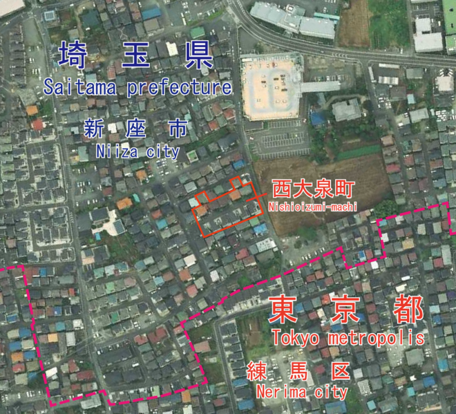
日本語: 東京都練馬区西大泉町付近の空中写真。都県境はGoogle Mapを参照して引いたものであり、正確な境界線を必要とする場合は、公図を参照してください。
English: An aerial photo of Nishioizumi-machi, Nerima, Tokyo, Japan. I drew the boundary of Saitama pref. and Tokyo metro. by data of google map. If you need more accurate boundary line, please refer to a public map.
วันที่ Taken on 23 สิงหาคม พ.ศ. 2560
แหล่งที่มา
日本語: 国土画像情報(カラー空中写真)(整理番号:CKT20176、コース番号:C29、写真番号:3、撮影年月日:2017年8月23日、撮影地域:東京、撮影高度:2197m、数値写真レベル:10000、カメラ名称:DMC2e-230、焦点距離:92.020mm、カラー種別:カラー、写真種別:デジタル、撮影計画機関:国土地理院、市区町村名:練馬区)https://mapps.gsi.go.jp/contentsImageDisplay.do?specificationId=1821347&isDetail=true
English: National Land Image Information (Color Aerial Photographs) (Reference number: CKT20176; Course Number: C29; Photo Number: 3; Date: August 23, 2017; Area: Tokyo; Height: 2197 metre; Numeric Photo Level: 10000; Camera Name: DMC2e-230; Focal distance: 92.020 millimetre; Color Type: Color; Photo Type: Digital; Agency: Geographical Survey Institute of Japan; Municipality: Nerima City) https://mapps.gsi.go.jp/contentsImageDisplay.do?specificationId=1821347&isDetail=true
ผู้สร้างสรรค์
English: Geographical Survey Institute of Japan
日本語: 国土地理院

การอนุญาตใช้สิทธิ

© Ministry of Land, Infrastructure, Transport and Tourism ซึ่งเป็นผู้ถือลิขสิทธิ์ของไฟล์นี้ อนุญาตให้นำไฟล์นี้ไปใช้ได้ในทุกวัตถุประสงค์ รวมไปถึงการทำซ้ำ การนำไฟล์นี้ไปใช้ในการสร้างไฟล์ใหม่ การใช้เพื่อการค้า และการใช้อื่น ๆ โดยมีเงื่อนไขว่า ต้องระบุชื่อผู้ถือลิขสิทธิ์ของไฟล์นี้อย่างเหมาะสมเมื่อนำไฟล์นี้ไปใช้
การแสดงที่มา:
National Land Image Information (Color Aerial Photographs), created by Ministry of Land, Infrastructure, Transport and Tourism, distributed by Geospatial Information Authority of Japan

Notice When you use this image on an article, please include the following phrase or equivalent for attribution and citation: "National Land Image Information (Color Aerial Photographs), created by Ministry of Land, Infrastructure, Transport and Tourism, distributed by Geospatial Information Authority of Japan."

คำบรรยายโดยย่อ

เพิ่มคำบรรยายทรรทัดเดียวเพื่อขยายความว่าไฟล์นี้มีอะไร

รายการที่แสดงอยู่ในไฟล์นี้

ประกอบด้วย

ประวัติไฟล์

คลิกวันที่/เวลาเพื่อดูไฟล์ที่ปรากฏในขณะนั้น

วันที่/เวลารูปย่อขนาดผู้ใช้ความเห็น
ปัจจุบัน20:29, 5 มิถุนายน 2564รูปย่อสำหรับรุ่นเมื่อ 20:29, 5 มิถุนายน 25641,087 × 987 (1.69 เมกะไบต์)Miyuki MeinakaUploaded a work by ((en|1=Geographical Survey Institute of Japan))((ja|1=国土地理院)) from ((ja|1=国土画像情報(カラー空中写真)(整理番号:CKT20176、コース番号:C29、写真番号:3、撮影年月日:2017年8月23日、撮影地域:東京、撮影高度:2197m、数値写真レベル:10000、カメラ名称:DMC2e-230、焦点距離:92.020mm、カラー種別:カラー、写真種別:デジタル、撮影計画機関:国土地理院、市区町村名:練馬区)https://mapps.gsi.go.jp/contentsImageDisplay.do?specificationId=1821347&isDetail=true)) ((en|1=National Land Image Information (Color Aerial Photographs) (Reference number: CKT20176; Course Number: C29; Photo Number: 3; Date: August 2...

หน้าที่มีภาพนี้

หน้าต่อไปนี้ โยงมาที่ภาพนี้:

การใช้ไฟล์ข้ามโครงการ

วิกิอื่นต่อไปนี้ใช้ไฟล์นี้:

ข้อมูลเกี่ยวกับภาพ

{{bottomLinkPreText}} {{bottomLinkText}}
ไฟล์:Nishioizumi-machi, CKT20176-C29-3.png
Listen to this article

This browser is not supported by Wikiwand :(
Wikiwand requires a browser with modern capabilities in order to provide you with the best reading experience.
Please download and use one of the following browsers:

This article was just edited, click to reload
This article has been deleted on Wikipedia (Why?)

Back to homepage

Please click Add in the dialog above
Please click Allow in the top-left corner,
then click Install Now in the dialog
Please click Open in the download dialog,
then click Install
Please click the "Downloads" icon in the Safari toolbar, open the first download in the list,
then click Install
{{::$root.activation.text}}

Install Wikiwand

Install on Chrome Install on Firefox
Don't forget to rate us

Tell your friends about Wikiwand!

Gmail Facebook Twitter Link

Enjoying Wikiwand?

Tell your friends and spread the love:
Share on Gmail Share on Facebook Share on Twitter Share on Buffer

Our magic isn't perfect

You can help our automatic cover photo selection by reporting an unsuitable photo.

This photo is visually disturbing This photo is not a good choice

Thank you for helping!


Your input will affect cover photo selection, along with input from other users.

X

Get ready for Wikiwand 2.0 🎉! the new version arrives on September 1st! Don't want to wait?