ไฟล์:Lower Egypt ancient nomes position map.jpg
ไม่มีภาพที่มีรายละเอียดสูงกว่านี้
Lower_Egypt_ancient_nomes_position_map.jpg (564 × 249 พิกเซล, ขนาดไฟล์: 28 กิโลไบต์, ชนิดไมม์: image/jpeg)
| รูปภาพหรือไฟล์เสียงนี้ ต้นฉบับอยู่ที่ คอมมอนส์ รายละเอียดด้านล่าง เป็นข้อความที่แสดงผลจาก ไฟล์ต้นฉบับในคอมมอนส์
|
ความย่อ
| คำอธิบาย |
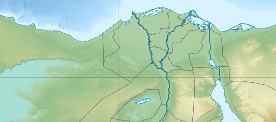
English: Location map of Lower Egypt Topographic scale: 1:4,932,000 (precision: 1,233 m) Equirectangular projection, WGS84 datum *Standard meridian: 030° 45' E *Central parallel: 26° 42' N Geographic limits of the map: * Top: 31° 45' N * Bottom: 29° 00' N * Left: 027° 00' E * Right: 034° 00' E |
| วันที่ | (UTC) |
| แหล่งที่มา | |
| ผู้สร้างสรรค์ |
|
| ภาพนี้ ได้รับการปรับแต่งภาพ ซึ่งหมายความว่าจะได้รับการเปลี่ยนแปลงภาพต่างจากต้นฉบับ การปรับปรุง: Extracted the Lower Egypt area. ต้นฉบับสามารถดูได้ที่นี่: Egypt relief location map.jpg. ปรับแต่งภาพโดย Bogomolov.PL.
|
ข้าพเจ้า ในฐานะผู้ถือลิขสิทธิ์ของภาพหรือสื่อนี้ อนุญาตให้ใช้ภาพหรือสื่อนี้ภายใต้เงื่อนไขต่อไปนี้
ไฟล์นี้อยู่ภายใต้สัญญาอนุญาต ครีเอทีฟคอมมอนส์ แบบแสดงที่มา-อนุญาตแบบเดียวกัน 3.0 ต้นฉบับ
- คุณสามารถ:
- ที่จะแบ่งปัน – ที่จะทำสำเนา แจกจ่าย และส่งงานดังกล่าวต่อไป
- ที่จะเรียบเรียงใหม่ – ที่จะดัดแปลงงานดังกล่าว
- ภายใต้เงื่อนไขต่อไปนี้:
- แสดงที่มา – คุณต้องให้เกียรติเจ้าของงานอย่างเหมาะสม โดยเพิ่มลิงก์ไปยังสัญญาอนุญาต และระบุหากมีการเปลี่ยนแปลง คุณอาจทำเช่นนี้ได้ในรูปแบบใดก็ได้ตามควร แต่ต้องไม่ใช่ในลักษณะที่แนะว่าผู้ให้อนุญาตสนับสนุนคุณหรือการใช้งานของคุณ
- อนุญาตแบบเดียวกัน – หากคุณดัดแปลง เปลี่ยนรูป หรือต่อเติมงานนี้ คุณต้องใช้สัญญาอนุญาตแบบเดียวกันหรือแบบที่เหมือนกับสัญญาอนุญาตที่ใช้กับงานนี้เท่านั้น

|
อนุญาตให้คัดลอก แจกจ่ายและ/หรือดัดแปรเอกสารนี้ภายใต้เงื่อนไขของสัญญาอนุญาตเอกสารเสรีของกนู รุ่น 1.2 หรือรุ่นใด ๆ นับจากนี้ที่ออกโดยมูลนิธิซอฟต์แวร์เสรี โดยไม่มีส่วนใดห้ามแก้ไข ไม่มีข้อความปกหน้าและปกหลัง สำเนาของสัญญาอนุญาตรวมอยู่ในส่วนชื่อ สัญญาอนุญาตเอกสารเสรีของกนู |
คุณสามารถเลือกสัญญาอนุญาตดังกล่าวตามต้องการ
ปูมการอัปโหลดต้นฉบับ
This image is a derivative work of the following images:
- File:Egypt_relief_location_map.jpg licensed with Cc-by-sa-3.0, GFDL
- 2011-04-18T13:59:05Z Sting 1055x975 (424455 Bytes) Updated after Governorats dissolution
- 2010-07-19T13:30:06Z Sting 1055x973 (462160 Bytes) Color profile
- 2010-03-07T19:04:48Z Sting 1055x973 (461278 Bytes) == ((int:filedesc)) == ((Location|26|42|00|N|30|45|00|E|scale:10000000)) ((Information |Description= ((de|Relief Positionskarte von [[:de:Ägypten|Ägypten]])) ((en|Physical location map of [[:en:Egypt|Egypt]].)) ((fr|Carte
Uploaded with derivativeFX
ประวัติไฟล์
คลิกวันที่/เวลาเพื่อดูไฟล์ที่ปรากฏในขณะนั้น
| วันที่/เวลา | รูปย่อ | ขนาด | ผู้ใช้ | ความเห็น | |
|---|---|---|---|---|---|
| ปัจจุบัน | 03:31, 20 มิถุนายน 2554 | | 564 × 249 (28 กิโลไบต์) | Bogomolov.PL | ((Information |Description=((en|Location map of Lower Egypt <br/> Topographic scale: 1:4,932,000 (precision: 1,233 m)<br/> Equirectangular projection, WGS84 datum<br/> *Standard meridian: 030° 45' E<br/> *Central parallel: 26° 42' N |
หน้าที่มีภาพนี้
หน้าต่อไปนี้ โยงมาที่ภาพนี้:
การใช้ไฟล์ข้ามโครงการ
วิกิอื่นต่อไปนี้ใช้ไฟล์นี้:
- การใช้บน azb.wikipedia.org
- การใช้บน bh.wikipedia.org
- การใช้บน bn.wikipedia.org
- การใช้บน en.wikipedia.org
- Battle of the Nile
- Pyramid of Djoser
- Suez
- Pyramid of Unas
- Pyramid of Neferirkare
- Battle of Heliopolis
- Pyramid of Sahure
- Pyramid of Neferefre
- Pyramid of Pepi I
- Pyramid of Djedkare Isesi
- Environmental issues in Egypt
- Haïm Capoussi Synagogue
- El Kurdi
- Headless Pyramid
- Module:Location map/data/Lower Egypt/doc
- User:Maggie39/sandbox
- Unfinished Pyramid of Abusir
- User:Archaeobuf/sandbox/hyksos
- Pyramid of Nyuserre
- Module:Location map/data/Lower Egypt
- Fatimid invasion of Egypt (914–915)
- Fatimid invasion of Egypt (919–921)
- Fatimid conquest of Egypt
- First Qarmatian invasion of Egypt
- Lepsius L
- การใช้บน es.wikipedia.org
- การใช้บน fa.wikipedia.org
- การใช้บน id.wikipedia.org
- การใช้บน ja.wikipedia.org
ดูการใช้ข้ามโครงการเพิ่มเติมของไฟล์นี้
ข้อมูลเกี่ยวกับภาพ
Text is available under the CC BY-SA 4.0 license; additional terms may apply.
Images, videos and audio are available under their respective licenses.
Cover photo is available under {{::mainImage.info.license.name || 'Unknown'}} license.
Cover photo is available under {{::mainImage.info.license.name || 'Unknown'}} license.
Credit:
(see original file).
