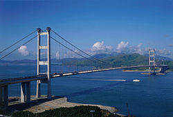
สะพานซิงหม่า
สะพานซิงหม่า | |
|---|---|
青馬大橋 | |
 สะพานมองจากซิงยี | |
| พิกัด | 22°21′05″N 114°04′27″E / 22.35139°N 114.07417°E |
| เส้นทาง | รถไฟ, ยานพาหนะ |
| ข้าม | ช่องแคบหม่าวัน |
| ที่ตั้ง | นิวเทร์ริทอรีส์ ฮ่องกง |
| เจ้าของ | รัฐบาลฮ่องกง |
| ผู้ดูแล | TIML MOM Limited (ภายใต้สัญญาของ Highways Department) |
| ข้อมูลจำเพาะ | |
| ประเภท | สะพานแขวนสองชั้น |
| ความกว้าง | 41 เมตร (135 ฟุต) |
| ช่วงยาวที่สุด | 1,377 เมตร (4,518 ฟุต) |
| เคลียร์ตอนล่าง | 53 เมตร (174 ฟุต) (จำกัดความสูงในการจัดส่งอย่างเป็นทางการ)[1] |
| ประวัติ | |
| ผู้ออกแบบ | มอตต์ แมคดอนัลด์ |
| ผู้สร้าง | กิจการร่วมค้าก่อสร้างอังกฤษ ญี่ปุ่น |
| วันเริ่มสร้าง | พฤษภาคม 1992 |
| วันสร้างเสร็จ | พฤษภาคม 1997 |
| งบก่อสร้าง | 7.14 พันล้านดอลลาร์ฮ่องกง |
| เปิดตัว | 27 เมษายน 1997 |
| วันเปิด | 22 พฤษภาคม 1997 |
| สถิติ | |
| การจราจรโดยเฉลี่ย | 87,764 คัน (2016)[2] (Lantau Link) |
| ค่าผ่าน | ไม่มี (ตั้งแต่วันที่ 27 ธันวาคม ค.ศ. 2020) |
| ที่ตั้ง | |
 | |
| สะพานซิงหม่า | |||||||||||||||||
| อักษรจีนตัวเต็ม | 青馬大橋 | ||||||||||||||||
|---|---|---|---|---|---|---|---|---|---|---|---|---|---|---|---|---|---|
| อักษรจีนตัวย่อ | 青马大桥 | ||||||||||||||||
| ความหมายตามตัวอักษร | สะพานใหญ่ซิงยี-หม่าวัน | ||||||||||||||||
| |||||||||||||||||
สะพานซิงหม่า (จีน: 青馬大橋; อังกฤษ: Tsing Ma Bridge) เป็นสะพานในฮ่องกง ซึ่งเป็นสะพานแขวนที่ยาวอันดับที่ 16 ของโลก และขณะสร้างเสร็จถือเป็นสะพานที่ยาวเป็นอันดับสองของโลก[3] สะพานนี้ตั้งชื่อตามชื่อเกาะที่สะพานเชื่อมอยู่ คือ เกาะซิงยีและเกาะหม่าวัน มีช่วงกลางยาว 1,377 เมตร (4,518 ฟุต) และสูง 206 เมตร (676 ฟุต)
ตัวสะพานมีความกว้าง 41-เมตร (135-ฟุต) มีสองชั้น ชั้นบนมีเส้นทางรถวิ่งจำนวน 6 ช่องทาง ส่วนชั้นล่างใช้สำหรับรถไฟ 2 ช่องทาง และช่องทางสำรองสำหรับรถยนต์ ในช่วงฤดูมรสุมอีก 4 ช่องทาง[4]
สะพานแห่งนี้เป็นเส้นทางสำคัญที่เชื่อมย่านธุรกิจในฮ่องกง กับเกาะลันเตา เพื่อไปยังท่าอากาศยานนานาชาติฮ่องกงบนเกาะเช็คแลปก๊ก
อ้างอิง
[แก้]- ↑ Heaver, Stuart (17 June 2017). "Tsing Ma Bridge height debacle costing Hong Kong billions". South China Morning Post.
- ↑ "Section 4: Road Tunnels and Control Areas". 2017 Annual Transport Digest. Transport Department.
- ↑ "10 Tallest Bridges in the World | Top Weird,Odd and Cool lists". Weirdly Odd. 2010-12-01. สืบค้นเมื่อ 2013-04-29.
- ↑ Evaluation of typhoon induced fatigue damage for Tsing Ma Bridge เก็บถาวร 26 มกราคม 2020 ที่ เวย์แบ็กแมชชีน[1]
อ่านเพิ่ม
[แก้]- Y. L. Xu, J. M. Ko and Z. Yu. "Modal analysis of tower-cable system of Tsing Ma long suspension bridge". Engineering Structures. Volume 19, Issue 10, October 1997, pp. 857–867.
แหล่งข้อมูลอื่น
[แก้]- Tsing Ma Bridge ที่ฐานข้อมูลโครงสร้าง (Structurae)
- Tsing Ma Bridge description from City University, Hong Kong (archive)
22°21′05″N 114°04′27″E / 22.35139°N 114.07417°E
| ก่อนหน้า อุโมงค์หนานวาน |
ฮ่องกงรูต 8 สะพานซิงหม่า |
ถัดไป สะพานรถไฟหม่าวัน |
Text is available under the CC BY-SA 4.0 license; additional terms may apply.
Images, videos and audio are available under their respective licenses.
