นาจาฟ
นาจาฟ ٱلنَّجَف อันนะญะฟุลอัชร็อฟ, บานีกิยา | |
|---|---|
เมือง | |
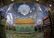
ศาลเจ้าอิหม่ามอะลี สถานที่ศักดิ์สิทธิ์ที่สุดของมุสลิมนิกายชีอะฮ์ และเป็นหนึ่งในสถานที่สำคัญที่สุดของนาจาฟ | |
| พิกัด: 32°00′00″N 44°20′00″E / 32.00000°N 44.33333°E | |
| ประเทศ | |
| เขตผู้ว่าการ | นาจาฟ |
| ความสูง | 60 เมตร (200 ฟุต) |
| ประชากร (2014) | |
| • ทั้งหมด | 1,389,500[1] คน |
| จำนวนประมาณ[2] | |
| เขตเวลา | UTC+3 |
นาจาฟ (อาหรับ: ٱلنَّجَف) หรือ อันนะญะฟุลอัชร็อฟ (อาหรับ: ٱلنَّجَف ٱلْأَشْرَف) มีอีกชื่อว่า บานีกิยา (อาหรับ: بَانِيقِيَا) เป็นเมืองในประเทศอิรักตอนกลาง ตั้งอยู่ทางใต้ของกรุงแบกแดด ราว 160 กิโลเมตร โดยมีประชากรใน ค.ศ. 2013 ประมาณ 1,000,000 คน[2] เป็นเมืองหลวงของเขตผู้ว่าการนาจาฟ ถือเป็นหนึ่งในเมืองศักดิ์สิทธิ์ของศาสนาอิสลามนิกายชีอะฮ์ และเป็นศูนย์กลางอำนาจทางการเมืองชีอะฮ์ของอิรักด้วย[8]
ชื่อ
[แก้]รายงานจากอิบน์ มันซูร คำว่า "นะญัฟ" (نجف) มีความหมายตรงตัวว่า สถานที่สูงรูปสี่เหลี่ยมผืนผ้าที่มีน้ำขังอยู่รอบ ๆ ถึงแม้ว่าน้ำจะไม่เอ่อล้นเกินระดับปกติก็ตาม[9] ส่วนอัชชัยคุศเศาะดูกยกฮะดีษจากอิหม่าม อัศศอดิกมาอ้างว่า คำว่า "นะญัฟ" มาจากวลี "nay jaff" ซึ่งหมายถึง "ทะเล nay แห้งไปแล้ว" แล้วค่อย ๆ เปลี่ยนแปลงไปเป็น "Najaf"[10]
ภูมิศาสตร์
[แก้]ภูมิอากาศ
[แก้]นาจาฟอยู่ในสภาพภูมิอากาศแบบทะเลทรายเขตร้อน (BWh) ตามการแบ่งเขตภูมิอากาศแบบเคิพเพิน ซึ่งมีฤดูร้อนที่ร้อนมากและยาวนาน และฤดูหนาวไม่รุนแรง อุณหภูมิรายปีเฉลี่ยอยู่ที่ 23.6 °C (74.5° F) หยาดน้ำฝนเฉลี่ยอยู่ที่ 69 มิลลิเมตร (2.71 นิ้ว)
| ข้อมูลภูมิอากาศของนาจาฟ | |||||||||||||
|---|---|---|---|---|---|---|---|---|---|---|---|---|---|
| เดือน | ม.ค. | ก.พ. | มี.ค. | เม.ย. | พ.ค. | มิ.ย. | ก.ค. | ส.ค. | ก.ย. | ต.ค. | พ.ย. | ธ.ค. | ทั้งปี |
| อุณหภูมิสูงสุดเฉลี่ย °C (°F) | 14.4 (58) |
18.3 (65) |
23.3 (74) |
30 (86) |
36.1 (97) |
40.6 (105) |
42.2 (108) |
41.7 (107) |
38.9 (102) |
32.8 (91) |
23.3 (74) |
16.7 (62) |
30 (86) |
| อุณหภูมิต่ำสุดเฉลี่ย °C (°F) | 6.7 (44) |
9.4 (49) |
13.3 (56) |
18.9 (66) |
23.3 (74) |
27.8 (82) |
29.4 (85) |
28.9 (84) |
26.7 (80) |
21.1 (70) |
12.8 (55) |
8.3 (47) |
18.9 (66) |
| อุณหภูมิต่ำสุดที่เคยบันทึก °C (°F) | -7.2 (19) |
-4.5 (23.9) |
2.2 (36) |
7.0 (44.6) |
13.0 (55.4) |
17.8 (64) |
19.4 (66.9) |
22.2 (72) |
18.3 (64.9) |
7.0 (44.6) |
0.2 (32.4) |
-2.5 (27.5) |
−7.2 (19) |
| หยาดน้ำฟ้า ซม (นิ้ว) | 3 (1) |
1 (0.5) |
1 (0.5) |
1 (0.5) |
1 (0.2) |
0 (0) |
0 (0) |
0 (0) |
0 (0) |
1 (0.2) |
1 (0.4) |
1 (0.4) |
7 (2.7) |
| แหล่งที่มา 1: Weatherbase[11] | |||||||||||||
| แหล่งที่มา 2: [12] | |||||||||||||
อ้างอิง
[แก้]- ↑ "Iraq: Governorates, Cities, Towns, Municipal Districts - Population Statistics in Maps and Charts". www.citypopulation.de.
- ↑ 2.0 2.1 Ring, Trudy (1996). "Najaf". Global Security. สืบค้นเมื่อ 2009-09-13.
- ↑ Cordesman, Anthony H.; Khazai, Sam (4 Jun 2014). Iraq in Crisis. Rowman & Littlefield. p. 319. ISBN 9781442228566.
- ↑ Cockburn, Patrick (8 Apr 2008). Muqtada: Muqtada al-Sadr, the Shia Revival, and the Struggle for Iraq (illustrated ed.). Simon and Schuster. p. 146. ISBN 9781416593744.
- ↑ Pollack, Kenneth M.; Alkadiri, Raad; J. Scott Carpenter; Kagan, Frederick W.; Kane, Sean (2011). Unfinished Business: An American Strategy for Iraq Moving Forward. Brookings Institution Press. p. 103. ISBN 9780815721666.
- ↑ Robinson, Linda (2005). Masters of Chaos: The Secret History of the Special Forces (illustrated, reprint ed.). PublicAffairs. p. 260. ISBN 9781586483524.
- ↑ "Ali al-Sistani is Iraq's best hope of curbing Iranian influence. But he is 85 and has no obvious successor". The Economist. 5 December 2015. สืบค้นเมื่อ 6 December 2015.
- ↑ [3][4][5][6][7]
- ↑ Ibn Manẓūr, Lisān al-ʿArab, under the word "Najaf".
- ↑ Ṣadūq, ʿIlal al-sharāʾiʿ, vol. 1, p. 31.
- ↑ "Weatherbase: Historical Weather for An Najaf, Iraq". Weatherbase. 2011. Retrieved on November 24, 2011.
- ↑ http://docs.lib.noaa.gov/rescue/data_rescue_iraq.html#o48577960
อ่านเพิ่ม
[แก้]- ตีพิมพ์ในคริสต์ศตวรรษที่ 19-20
- Charles Wilson, บ.ก. (1895), "Nejef", Handbook for Travellers in Asia Minor, Transcaucasia, Persia, etc., London: John Murray, ISBN 9780524062142, OCLC 8979039
 Peters, John Punnett (1911). . ใน Chisholm, Hugh (บ.ก.). สารานุกรมบริตานิกา ค.ศ. 1911. Vol. 19 (11 ed.). สำนักพิมพ์มหาวิทยาลัยเคมบริดจ์. p. 352.
- ตีพิมพ์ในคริสต์ศตวรรษที่ 21
- C. Edmund Bosworth, บ.ก. (2007). "Najaf". Historic Cities of the Islamic World. Leiden: Koninklijke Brill. ISBN 978-9004153882.
- Michael R. T. Dumper; Bruce E. Stanley, บ.ก. (2007), "Najaf", Cities of the Middle East and North Africa, Santa Barbara, Calif.: ABC-CLIO (ตีพิมพ์ 2008), ISBN 978-1576079195
แหล่งข้อมูลอื่น
[แก้]เมืองที่ใหญ่ที่สุดในประเทศอิรัก จากสำมะโนประมาณ พ.ศ. 2561[1] | |||||||||||||||||||||||||||||||||||||||||||||||||
|---|---|---|---|---|---|---|---|---|---|---|---|---|---|---|---|---|---|---|---|---|---|---|---|---|---|---|---|---|---|---|---|---|---|---|---|---|---|---|---|---|---|---|---|---|---|---|---|---|---|
| |||||||||||||||||||||||||||||||||||||||||||||||||
32°00′N 44°20′E / 32.00°N 44.33°E
| นานาชาติ | |
|---|---|
| ประจำชาติ | |
| อื่น ๆ | |
Text is available under the CC BY-SA 4.0 license; additional terms may apply.
Images, videos and audio are available under their respective licenses.


