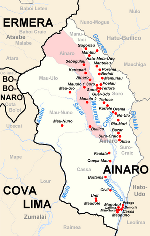
Ainaru
| Suku Ainaru | |||

| |||
| Área | 30,75 km²[1] | ||
| Populasaun | 6.937 (2010)[2] | ||
| Xefe de Suku | Agapito Fatima Martins (Eleisaun 2009) | ||
| Vila | Position[3] | Altitude | |
| Builico | 9° 3′ S, 125° 31′ O-9.0452777777778125.50888888889492 | 492 m | |
| Kertapati | 8° 59′ S, 125° 30′ O-8.9827777777778125.49972222222916 | 916 m | |
| Mauulo 1 | 9° 0′ S, 125° 30′ O-9.0044444444444125.50083333333735 | 735 m | |
| Mauulo 2 | 9° 1′ S, 125° 30′ O-9.0172222222222125.50361111111664 | 664 m | |
| Sebagulau | 8° 59′ S, 125° 30′ O-8.9755555555556125.501388888891005 | 1005 m | |
Ainaru (iha lia-portugés: Ainaro) sidade ho suku ida iha Timór Lorosa'e. Ainaru mak sai sidade kapitál ba postu administrativu Ainaru ho ba munisípiu Ainaru.
Sidade Ainaro
[edita]
Sidade Ainaro populasaun 3.085 (2006).
Ainaru iha bin sidade ho Madison, Wisconsin (USA).[1]
Suku Ainaru
[edita]
Suku Ainaru populasaun 6.937 (2010).[2] Área 30,75 km²[1]
Aldeias:[5]
- Builico
- Hato-Mera (Hatumera)
- Lugatú
- Nugufú
- Sebagulau
- Teliga.
Ligasaun ba li'ur
[edita]| Commons: Ainaru – Imajen sira |
Referensia
[edita]- ↑ 1,0 1,1 Direcção Nacional de Estatística: Population Distribution by Administrative Areas Volume 2 English Archived 2017-01-05 iha Wayback Machine. (Census 2010; PDF; 22,6 MB) Erro de citação: Código
<ref>inválido; o nome "Census2010-2" é definido mais de uma vez com conteúdos diferentes - ↑ 2,0 2,1 Direcção Nacional de Estatística: Suco Report Volume 4 (englisch) Archived 2015-04-09 iha Wayback Machine. (PDF; 9,8 MB) Erro de citação: Código
<ref>inválido; o nome "SR2015" é definido mais de uma vez com conteúdos diferentes - ↑ Fallingrain.com: Directory of Cities, Towns, and Regions in East Timor
- ↑ Seeds of Life
- ↑ Jornal da Républica mit dem Diploma Ministerial n.° 199/09 Archived 2010-02-03 iha Wayback Machine. (Portugiesisch; PDF; 323 kB)
| Kapitál Munisípiu Timór Lorosa'e nian | |
|---|---|
| Aileu | Ainaru | Baukau | Dili | Gleno | Lospalos | Likisá | Maliana | Manatutu | Pante-Makasár | Same | Suai | Vikeke | |
| Suku postu administrativu Ainaru nian | |
|---|---|
| Ainaru | Kassa (Cassa) | Manutasi (Manutaci) | Mau-Nuno | Mau-Ulo | Soro | Suro Kraik (Suro-Craic) | |
-8.9833333333333125.5Koordinaten: 8° 59′ S, 125° 30′ O
Text is available under the CC BY-SA 4.0 license; additional terms may apply.
Images, videos and audio are available under their respective licenses.


