దస్త్రం:Arunachal Pradesh in India.png
వికీపీడియా నుండి
Arunachal_Pradesh_in_India.png (350 × 425 పిక్సెళ్ళు, ఫైలు పరిమాణం: 80 KB, MIME రకం: image/png)
This is a file from the Wikimedia Commons. Information from its description page there is shown below. Commons is a freely licensed media file repository. You can help. |
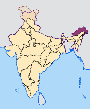
Map made by me, Nichalp
Note: The Indian state of w:Arunachal Pradesh is claimed by China as a part of w:South Tibet. The claimed region is shown in a different colour.
The Indian state of w:Jammu and Kashmir is claimed by w:India, w:Pakistan and the w:People's Republic of China. This map depicts the boundaries of the state as it was in 1947. Areas administered by India is coloured as per the rest of the states, and the area administered by Pakistan and China are coloured in a neutral colour. See the map of Jammu and Kashmir.
See the map of Arunachal Pradesh.
The Indian territorial waters extend to a distance of twelve nautical miles.

|
ఈ కృతి యొక్క కర్తనైన నేను, ఇక నుండీ ఈ కృతిని కాపీ చేసుకోవడానికి, పంచి పెట్టడానికి మరియు/లేదా మార్పులు-చేర్పులు చేసుకోవడానికి GFDL, లైసెన్సు వెర్షను 1.2 లేదా దాని తరువాత స్వేచ్చా సాఫ్టువేరు ఫౌండేషను విడుదలచేసే ఏ GFDL లైసెన్సు ద్వారా నయినా అనుమతి ఇస్తున్నాను; ఈ కృతిలో మార్చకూడని బాగాలు లేవు, Front-Cover పాఠం లేదు, Back-Cover పాఠం లేదు. ఈ లైసెన్సు యొక్క పత్రం నకలును "జిఎన్యూ ఉచిత డాక్యుమెంటేషను లైసెన్సు" అని పిలుస్తున్న విభాగంలో ఉంది. |
| ఈ దస్త్రం క్రియేటివ్ కామన్స్ Attribution-Share Alike 3.0 Unported లైసెన్సు క్రింద లభ్యం. | ||
| ||
| GFDL లైసెన్సు తాజాకరణలో భాగంగా ఈ దస్త్రానికి ఈ లైసెన్సింగు ట్యాగుని చేర్చారు. |
ఫైలు చరితం
తేదీ/సమయం ను నొక్కి ఆ సమయాన ఫైలు ఎలా ఉండేదో చూడవచ్చు.
| తేదీ/సమయం | నఖచిత్రం | కొలతలు | వాడుకరి | వ్యాఖ్య | |
|---|---|---|---|---|---|
| ప్రస్తుత | 07:27, 23 ఏప్రిల్ 2005 | | 350 × 425 (80 KB) | Nichalp | NPOV map |
| 07:21, 23 ఏప్రిల్ 2005 |  | 200 × 231 (22 KB) | Kerpal | Reverted to earlier revision | |
| 06:13, 23 ఏప్రిల్ 2005 |  | 650 × 790 (126 KB) | Nichalp | Reverted to earlier revision | |
| 04:59, 23 ఏప్రిల్ 2005 |  | 200 × 231 (22 KB) | Kerpal | Reverted to earlier revision | |
| 04:50, 23 ఏప్రిల్ 2005 |  | 650 × 790 (126 KB) | Nichalp | Reverted to earlier revision | |
| 21:04, 22 ఏప్రిల్ 2005 |  | 200 × 231 (22 KB) | Kerpal | Reverted to earlier revision | |
| 13:32, 22 ఏప్రిల్ 2005 |  | 650 × 790 (126 KB) | Nichalp | Reverted to earlier revision | |
| 09:55, 22 ఏప్రిల్ 2005 |  | 200 × 231 (22 KB) | Kerpal | originally by en:User:Morwen | |
| 17:47, 21 ఏప్రిల్ 2005 |  | 650 × 790 (126 KB) | Nichalp | Map made by me, ~~~ Note: The Indian state of w:Jammu and Kashmir is claimed by w:India, w:Pakistan and the [w:People's Republic of China]]. This map depicts the boundaries of the state as it was in 1947. Areas administered by India is colou |
లింకులు
కింది పేజీలలో ఈ ఫైలుకు లింకులు ఉన్నాయి:
సార్వత్రిక ఫైలు వాడుక
ఈ దస్త్రాన్ని ఈ క్రింది ఇతర వికీలు ఉపయోగిస్తున్నాయి:
- bxr.wikipedia.org లో వాడుక
- de.wikipedia.org లో వాడుక
- en.wikipedia.org లో వాడుక
- fi.wikipedia.org లో వాడుక
- incubator.wikimedia.org లో వాడుక
- ka.wikipedia.org లో వాడుక
- mr.wikipedia.org లో వాడుక
- ta.wikipedia.org లో వాడుక
- xmf.wikipedia.org లో వాడుక
మెటాడేటా
Text is available under the CC BY-SA 4.0 license; additional terms may apply.
Images, videos and audio are available under their respective licenses.
