Västra Tommarp
| Västra Tommarp | |
| Tätort | |
| Land | |
|---|---|
| Landskap | Skåne |
| Län | Skåne län |
| Kommun | Trelleborgs kommun |
| Distrikt | Västra Tommarps distrikt |
| Koordinater | 55°23′49″N 13°6′10″Ö / 55.39694°N 13.10278°Ö |
| Area | 33 hektar (2020)[1] |
| Folkmängd | 418 (2020)[1] |
| Befolkningstäthet | 12,7 inv./hektar |
| Tidszon | CET (UTC+1) |
| - sommartid | CEST (UTC+2) |
| Tätortskod | T3806[2] |
| Småortskod | S3885[3] |
| Beb.områdeskod | 1287SB146 (1990–2010)[4] 1287TB111 (2010–)[4] |
| Geonames | 2663709 |
|
Ortens läge i Skåne län
| |
| Wikimedia Commons: Västra Tommarp | |
| SCB:s bebyggelseområdesavgränsning Redigera Wikidata | |
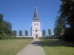
Västra Tommarp är en tätort på Söderslätt i Trelleborgs kommun och kyrkby i Västra Tommarps socken i Skåne. Här ligger Västra Tommarps kyrka.
Befolkningsutveckling
[redigera | redigera wikitext]| Befolkningsutvecklingen i Västra Tommarp 2010–2020[5] | ||||
|---|---|---|---|---|
| År | Folkmängd | Areal (ha) | ||
| 2010 | 214 | 20 | ||
| 2015 | 286 | 33 | ||
| 2020 | 418 | 33 | ||
Anm.: Ny tätort 2010
| ||||
Västra Tommarp klassas som tätort från 2010. Tidigare räknades området som en småort eftersom befolkningen då inte var över 200 personer.
Personer från orten
[redigera | redigera wikitext]Från orten kom professorna i medicin Hans Bendz och Arvid Sture Bruzelius samt folklivsforskaren och arkeologen Nils G. Bruzelius.
Noter
[redigera | redigera wikitext]- ^ [a b c] Statistiska tätorter 2020, befolkning, landareal, befolkningstäthet per tätort, SCB, 24 november 2021, läs online.[källa från Wikidata]
- ^ Befolkning i tätorter 1960-2010, SCB, läs online, läst: 20 mars 2014.[källa från Wikidata]
- ^ Småorternas landareal, folkmängd och invånare per km² 2005 och 2010, korrigerad 2012-10-15, SCB, 15 oktober 2012, läs online, läst: 9 juli 2016.[källa från Wikidata]
- ^ [a b] Kodnyckel för SCB:s statistiska tätorter och småorter - Koppling mellan gammalt och nytt kodsystem, SCB, 11 november 2021, läs online.[källa från Wikidata]
- ^ ”Landareal per tätort, folkmängd och invånare per kvadratkilometer. Vart femte år 1960 - 2016”. Statistiska centralbyrån. Arkiverad från originalet den 13 juni 2017. https://web.archive.org/web/20170613011648/http://www.statistikdatabasen.scb.se/pxweb/sv/ssd/START__MI__MI0810__MI0810A/LandarealTatort/?rxid=ff9309f9-7ecb-480f-a73c-08d86b3e56f8. Läst 18 maj 2017.
| ||||||||||||||||
Text is available under the CC BY-SA 4.0 license; additional terms may apply.
Images, videos and audio are available under their respective licenses.


