Hodh El Gharbi
| Hodh El Gharbi | |
| ولاية الحوض الغربي | |
| Region | |
Landskap i Hodh El Gharbi
| |
| Land | |
|---|---|
| Departement | Aioun Al Atrouss Kobenni Tamchaket Tintane |
| Huvudort | Aioun Al Atrouss |
| Area | 48 674 km²[1] |
| Folkmängd | 294 109 (2013)[2] |
| Befolkningstäthet | 6 invånare/km² |
| Tidszon | GMT (UTC±0) |
| Geonames | 2379024 |
|
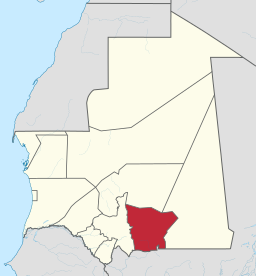
Regionens läge i Mauretanien
| |
|
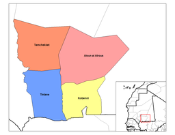
Indelning av Hodh El Gharbi i departement
| |
Hodh El Gharbi (arabiska: ولاية الحوض الغربي) är en region i södra Mauretanien. Huvudort är Aioun Al Atrouss. Den gränsar till Mali i söder. Regionen hade 294 109 invånare vid folkräkningen år 2013.[2]
Hodh El Gharbi består av 4 departement (moughataa).
| Departement (moughataa) |
Folkmängd (2013)[2] |
Kommuner[2] |
|---|---|---|
| Aioun Al Atrouss | 65 237 |
|
| Kobenni | 92 690 |
|
| Tamchaket | 39 013 |
|
| Tintane | 97 169 |
|
Referenser
[redigera | redigera wikitext]- ^ ”Mauritania - Subnational Administrative Boundaries - Humanitarian Data Exchange” (på engelska). data.humdata.org. https://data.humdata.org/dataset/cod-ab-mrt. Läst 9 april 2023.
- ^ [a b c d] ”Population des Wilayas, Moughataa et Communes” (
 PDF). Recensement Général de la Population et de l'Habitat (RGPH 2013). Office National de la Statistique. http://www.dgct.mr/wp-content/uploads/2016/06/Populations-2013-brochure-RGPH_Final-4-aou.pdf. Läst 8 april 2023.
Externa länkar
[redigera | redigera wikitext] Wikimedia Commons har media som rör Hodh El Gharbi.
| |||||||
Text is available under the CC BY-SA 4.0 license; additional terms may apply.
Images, videos and audio are available under their respective licenses.


