For faster navigation, this Iframe is preloading the Wikiwand page for Fil:2011Sendai-NOAA-Energylhvpd9-05.jpg.

Fil:2011Sendai-NOAA-Energylhvpd9-05.jpg
Originalfil(1 318 × 918 pixlar, filstorlek: 315 kbyte, MIME-typ: image/jpeg)

Beskrivning
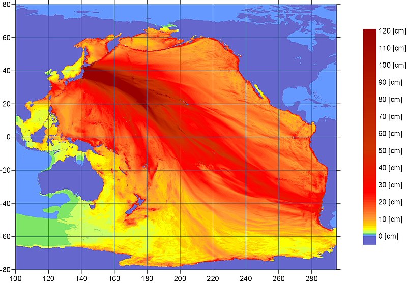
Deutsch: Tsunami-Ausbreitungsvorhersage (NOAA). Wellenhöhen farblich wiedergegeben.
English: Ocean energy distribution forecast map for the 2011 Sendai earthquake from the U.S. NOAA
日本語:2011年東北地方太平洋沖地震で引き起こされた津波のエネルギー伝播の予測。アメリカ海洋大気圏局 NOAAによる試算。
Français : Carte prévisionnelle de l'amplitude de la vague du tsunami dans l'océan pour le séisme de Sendai de 2011, d'après la NOAA. L'échelle s'arrête à 120 cm, mais les vagues sur les côtes du Japon on été beaucoup plus importantes.
Datum
Källa wcatwc.arh.noaa.gov (direct image URL [1]) There is a similar image here with a caption; "contours of forecasted maximum wave amplitudes [cm], detailing tsunami energy propagation". Presumably the scale simply stops at 120cm; but at the coasts the wave rises much higher.
Skapare West Coast & Alaska Tsunami Warning Center, National Oceanic and Atmospheric Administration
Tillstånd
(Återanvändning av denna fil)
Public domain
This image is in the public domain because it contains materials that originally came from the U.S. National Oceanic and Atmospheric Administration, taken or made as part of an employee's official duties.

العربية  čeština  Deutsch  Zazaki  English  español  eesti  suomi  français  hrvatski  magyar  italiano  日本語  한국어  македонски  മലയാളം  Plattdüütsch  Nederlands  polski  português  română  русский  sicilianu  slovenščina  Türkçe  Tiếng Việt  简体中文  繁體中文  +/−

Andra versioner

Bildtexter

Ingen bildtext har definierats

Objekt som porträtteras i den här filen

motiv

image/jpeg

9862e865934bc74f946d1d8c21fda0dc7283c446

322 993 byte

918 pixel

1 318 pixel

Filhistorik

Klicka på ett datum/klockslag för att se filen som den såg ut då.

Datum/TidMiniatyrbildDimensionerAnvändareKommentar
nuvarande11 mars 2011 kl. 12.31Miniatyrbild för versionen från den 11 mars 2011 kl. 12.311 318 × 918 (315 kbyte)Clindberg((Information |Description=Ocean energy distribution map for the 2011 Sendai earthquake from the U.S. NOAA |Source=[http://wcatwc.arh.noaa.gov/ wcatwc.arh.noaa.gov] (direct image URL [http://wcatwc.arh.noaa.gov/2011/03/11/lhvpd9/energylhvpd9-05.jpg]) |Dat

Filanvändning

Följande sida använder den här filen:

Global filanvändning

Följande andra wikier använder denna fil:

{{bottomLinkPreText}} {{bottomLinkText}}
Fil:2011Sendai-NOAA-Energylhvpd9-05.jpg
Listen to this article

This browser is not supported by Wikiwand :(
Wikiwand requires a browser with modern capabilities in order to provide you with the best reading experience.
Please download and use one of the following browsers:

This article was just edited, click to reload
This article has been deleted on Wikipedia (Why?)

Back to homepage

Please click Add in the dialog above
Please click Allow in the top-left corner,
then click Install Now in the dialog
Please click Open in the download dialog,
then click Install
Please click the "Downloads" icon in the Safari toolbar, open the first download in the list,
then click Install
{{::$root.activation.text}}

Install Wikiwand

Install on Chrome Install on Firefox
Don't forget to rate us

Tell your friends about Wikiwand!

Gmail Facebook Twitter Link

Enjoying Wikiwand?

Tell your friends and spread the love:
Share on Gmail Share on Facebook Share on Twitter Share on Buffer

Our magic isn't perfect

You can help our automatic cover photo selection by reporting an unsuitable photo.

This photo is visually disturbing This photo is not a good choice

Thank you for helping!


Your input will affect cover photo selection, along with input from other users.

X

Get ready for Wikiwand 2.0 🎉! the new version arrives on September 1st! Don't want to wait?