For faster navigation, this Iframe is preloading the Wikiwand page for Датотека:Zakarid Armenia 1200 map-fr.svg.

Датотека:Zakarid Armenia 1200 map-fr.svg
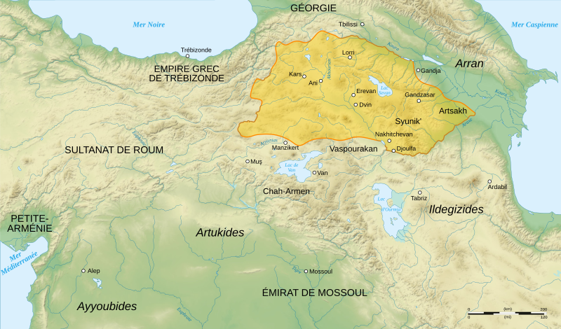
Оригинална датотека(SVG датотека, номинално 2.717 × 1.595 пиксела, величина: 686 kB)

Опис

Опис
English: French map of Zakarid Armenia, around the year 1200 AD. (Source: George A. Bournoutian - «A Concise History of the Armenian People», map 19. Mazda Publishers, Inc. Costa Mesa California 2006)
Français : Carte en français de l'Arménie zakaride, vers l'an mille.
Датум
Извор

Сопствено дело. Sources :

Logiciels utilisés :

Autres données :

  • projection cartographique UTM
  • Système géodésique WGS84
Аутор Sémhur
Остале верзије
Ауторство
(required by the license)
InfoField
© Sémhur / Wikimedia Commons / 
© Sémhur / Wikimedia Commons
SVG
InfoField
 
W3C-validity not checked.
 
This W3C-unspecified vector image was created with Inkscape…important .
Translate this file

Ова SVG датотека користи уграђени текст који се може лако превести на ваш језик. Више детаља. За SVG слике можете користити [toolforge:svgtranslate/File:Zakarid_Armenia_1200_map-fr.svglink ову страницу] како бисте је превели на ваш језик.

Graphic Lab
InfoField
Положај камере38° 33′ 00″ С, 42° 15′ 36″ И  Heading=0° Kartographer map based on OpenStreetMap.Ова и друге слике снимљене у близини на: OpenStreetMapinfo

Лиценцирање

Ја, носилац ауторских права над овим делом, објављујем исто под следећим лиценцама:
Licence Art Libre Copyleft: This work of art is free; you can redistribute it and/or modify it according to terms of the Free Art License. You will find a specimen of this license on the Copyleft Attitude site as well as on other sites.
w:sr:Creative Commons
ауторство делити под истим условима
Ова датотека је доступна под лиценцом Creative Commons Ауторство-Делити под истим условима 4.0 међународна, 3.0 Unported, 2.5 Генеричка, 2.0 Генеричка и 1.0 Генеричка.
Дозвољено је:
  • да делите – да умножавате, расподељујете и преносите дело
  • да прерађујете – да прерадите дело
Под следећим условима:
  • ауторство – Морате да дате одговарајуће заслуге, обезбедите везу ка лиценци и назначите да ли су измене направљене. Можете то урадити на било који разуман манир, али не на начин који предлаже да лиценцатор одобрава вас или ваше коришћење.
  • делити под истим условима – Ако измените, преобразите или доградите овај материјал, морате поделити своје доприносе под истом или компатибилном лиценцом као оригинал.
Изаберите лиценцу по жељи.

Натписи

Укратко шта ова датотека представља/приказује

Ставке приказане у овој датотеци

приказује

3. август 2008

38°33'0"N, 42°15'36"E

азимут камере: 0 лучни степен

Историја датотеке

Кликните на датум/време да бисте видели тадашњу верзију датотеке.

Датум/времеМинијатураДимензијеКорисникКоментар
тренутна02:24, 20. децембар 2015.Минијатура за верзију на дан 02:24, 20. децембар 2015.2.717 × 1.595 (686 kB)GeageaReverted to version as of 18:22, 3 August 2008 (UTC). Please upload the file with a new filename. Also see COM:OVERWRITE
18:48, 19. децембар 2015.Минијатура за верзију на дан 18:48, 19. децембар 2015.2.717 × 1.595 (640 kB)ErcwlffZakarid Armenia was not an independent kingdom and it had to be shown here
18:19, 18. децембар 2015.Минијатура за верзију на дан 18:19, 18. децембар 2015.2.717 × 1.595 (686 kB)DennissReverted to version as of 18:22, 3 August 2008 (UTC) - map is tagged/named as having french language, please upload under new name
16:55, 18. децембар 2015.Минијатура за верзију на дан 16:55, 18. децембар 2015.2.717 × 1.595 (728 kB)Georgianotranslated into English. it's looks more historically accurate now
20:22, 3. август 2008.Минијатура за верзију на дан 20:22, 3. август 2008.2.717 × 1.595 (686 kB)SémhurTypography
18:19, 3. август 2008.Минијатура за верзију на дан 18:19, 3. август 2008.2.717 × 1.595 (687 kB)Sémhur== Description == ((Information |Description= ((en| French map of Zakarid Armenia, around the year 1200 AD.)) ((fr| Carte en français de l'Arménie zakaride, vers l'an mille.)) |Source=Travail personnel. Sources : * Fond de carte : [http://www2.jpl.nasa.

Употреба датотеке

Следећа страница користи ову датотеку:

Глобална употреба датотеке

Други викији који користе ову датотеку:

Још глобалног коришћења ове датотеке.

Метаподаци

{{bottomLinkPreText}} {{bottomLinkText}}
Датотека:Zakarid Armenia 1200 map-fr.svg
Listen to this article

This browser is not supported by Wikiwand :(
Wikiwand requires a browser with modern capabilities in order to provide you with the best reading experience.
Please download and use one of the following browsers:

This article was just edited, click to reload
This article has been deleted on Wikipedia (Why?)

Back to homepage

Please click Add in the dialog above
Please click Allow in the top-left corner,
then click Install Now in the dialog
Please click Open in the download dialog,
then click Install
Please click the "Downloads" icon in the Safari toolbar, open the first download in the list,
then click Install
{{::$root.activation.text}}

Install Wikiwand

Install on Chrome Install on Firefox
Don't forget to rate us

Tell your friends about Wikiwand!

Gmail Facebook Twitter Link

Enjoying Wikiwand?

Tell your friends and spread the love:
Share on Gmail Share on Facebook Share on Twitter Share on Buffer

Our magic isn't perfect

You can help our automatic cover photo selection by reporting an unsuitable photo.

This photo is visually disturbing This photo is not a good choice

Thank you for helping!


Your input will affect cover photo selection, along with input from other users.

X

Get ready for Wikiwand 2.0 🎉! the new version arrives on September 1st! Don't want to wait?