For faster navigation, this Iframe is preloading the Wikiwand page for Датотека:Macedonia-Thracia-Illyria-Moesia-Dacia1849.jpg.

Датотека:Macedonia-Thracia-Illyria-Moesia-Dacia1849.jpg

Оригинална датотека(2.038 × 1.677 пиксела, величина датотеке: 1,12 MB, MIME тип: image/jpeg)

Опис

Опис

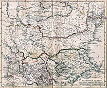
Macedonia, Thracia, Illyria, Moesia, Dacia,(Map X)"Comment on Map from author; Map X., & c. - Although most portions of this map are well represented, still we have a deficiency in the classical portion, as it has not been yet sufficiently examined by those who are capable of deciding and systematizing the comparative geography."

  • This map includes even 2nd century AD (i.e. Adrianopolis) cities and perhaps even later ones.
  • This map is a Post-Roman conquest map, the atlas was called "classical" and included many types of maps.
  • Locations of many cities, tribes or other features are according to 1849 scholarship and not up to date. For example, many cities shown have not been identified yet and Findlay made arbirtrary conclusions. A great omission is that Lake Prespas are missing.
Датум
Извор A classical atlas, to illustrate ancient geography: comprised in twenty-five maps, showing the various divisions of the world as known to the ancients : composed from the most authentic sources with an index of the ancient and modern names,Alexander G. Findlay,Publisher;Harper,1849
Аутор Alexander G. Findlay
Дозвола
(Поновно коришћење ове датотеке)
Public domain

Овај рад је такође у јавном власништву у државама са роком ауторства за живота аутора плус 70 година или мање.


Морате такође ставити ознаку за јавно власништво у Сједињеним Државама да би се знало зашто је овај рад у јавном власништву у Сједињеним Државамa.
Остале верзије
Public domain

Овај рад је такође у јавном власништву у државама са роком ауторства за живота аутора плус 70 година или мање.


Морате такође ставити ознаку за јавно власништво у Сједињеним Државама да би се знало зашто је овај рад у јавном власништву у Сједињеним Државамa.

Натписи

Укратко шта ова датотека представља/приказује

Ставке приказане у овој датотеци

приказује

14. март 2006

Историја датотеке

Кликните на датум/време да бисте видели тадашњу верзију датотеке.

Датум/времеМинијатураДимензијеКорисникКоментар
тренутна23:15, 14. март 2006.Минијатура за верзију на дан 23:15, 14. март 2006.2.038 × 1.677 (1,12 MB)JuloBalkans 1849 ((PD-old)) category:19th century mapsCategory:Historical maps of the BalkansCategory:Historical maps of Europe

Употреба датотеке

Следећа страница користи ову датотеку:

Глобална употреба датотеке

Други викији који користе ову датотеку:

{{bottomLinkPreText}} {{bottomLinkText}}
Датотека:Macedonia-Thracia-Illyria-Moesia-Dacia1849.jpg
Listen to this article

This browser is not supported by Wikiwand :(
Wikiwand requires a browser with modern capabilities in order to provide you with the best reading experience.
Please download and use one of the following browsers:

This article was just edited, click to reload
This article has been deleted on Wikipedia (Why?)

Back to homepage

Please click Add in the dialog above
Please click Allow in the top-left corner,
then click Install Now in the dialog
Please click Open in the download dialog,
then click Install
Please click the "Downloads" icon in the Safari toolbar, open the first download in the list,
then click Install
{{::$root.activation.text}}

Install Wikiwand

Install on Chrome Install on Firefox
Don't forget to rate us

Tell your friends about Wikiwand!

Gmail Facebook Twitter Link

Enjoying Wikiwand?

Tell your friends and spread the love:
Share on Gmail Share on Facebook Share on Twitter Share on Buffer

Our magic isn't perfect

You can help our automatic cover photo selection by reporting an unsuitable photo.

This photo is visually disturbing This photo is not a good choice

Thank you for helping!


Your input will affect cover photo selection, along with input from other users.

X

Get ready for Wikiwand 2.0 🎉! the new version arrives on September 1st! Don't want to wait?