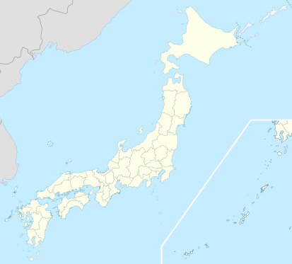
Датотека:Japan location map with side map of the Ryukyu Islands.svg

Оригинална датотека (SVG датотека, номинално 413 × 373 пиксела, величина: 980 kB)
Историја датотеке
Кликните на датум/време да бисте видели тадашњу верзију датотеке.
| Датум/време | Минијатура | Димензије | Корисник | Коментар | |
|---|---|---|---|---|---|
| тренутна | 16:21, 3. април 2022. |  | 413 × 373 (980 kB) | Peka | Reverted to version as of 10:18, 10 August 2021; no discuss about this change |
| 12:18, 10. август 2021. |  | 413 × 373 (1,56 MB) | Jeebeen | Liancourts Rock isn't territory of Japan | |
| 07:19, 14. новембар 2020. |  | 413 × 373 (980 kB) | AichiWikiFixer | Fix borders. | |
| 15:53, 30. октобар 2010. |  | 413 × 373 (926 kB) | NordNordWest | Liancourts Rock boundary | |
| 03:15, 17. септембар 2010. |  | 413 × 373 (1,56 MB) | Dinamik | medium color for disputed territories | |
| 13:41, 21. март 2010. |  | 413 × 373 (1,52 MB) | Chumwa | Präfekturgrenzen bereinigt | |
| 15:33, 20. март 2010. |  | 413 × 373 (1,71 MB) | Chumwa | Trennlinie zu Nebenkarte etwas verbreitert | |
| 11:50, 20. март 2010. |  | 413 × 373 (1,92 MB) | Chumwa | == ((int:filedesc)) == ((Information |Description= ((de|Postionskarte von Japan)) Quadratische Plattkarte. Bei Nutzung der Hauptkarte mit den Hauptinseln gelten folgende geographische Begrenzungen für die (Gesamt-)Karte: * N: 45°51'37" N |
Употреба датотеке
Више од 100 страница користи ову датотеку. Следећи списак приказује првих 100 страница које користе само ову датотеку. Доступан је и потпуни списак.
- Јамагата
- Јао
- Јокаичи
- Јокосука
- Јокохама
- Абико
- Акаши
- Акита (град)
- Амагасаки
- Аомори
- Асахикава
- Вакајама
- Гифу
- Земљотрес и цунами у Тохоку 2011.
- Ибараки
- Иваки
- Ичикава
- Ичиномија
- Ичихара
- Кавагое
- Кавагучи
- Кавасаки
- Кагошима
- Какогава
- Камакура
- Каназава
- Касугај
- Касукабе
- Кашива
- Китакјушу
- Кобе
- Коријама
- Кочи
- Кошигаја
- Кумамото
- Курашики
- Куруме
- Куширо
- Кјото
- Маебаши
- Мацудо
- Мацујама
- Мачида
- Мито (Ибараки)
- Мијазаки
- Мориока
- Нагано
- Нагасаки
- Нагоја
- Нара
- Наха
- Нејагава
- Нигата
- Нишиномија
- Оита
- Оказаки
- Окајама
- Окума
- Осака
- Оцу
- Сагамихара
- Саитама
- Сакај
- Сапоро
- Сасебо
- Светско првенство у кошарци 2006.
- Светско првенство у фудбалу 2002.
- Сендај
- Суита
- Такамацу
- Такасаки
- Такацуки
- Токио
- Токорозава
- Токушима
- Тојама
- Тојонака
- Тојота (Аичи)
- Тојохаши
- Универзитет у Токију
- Уцуномија
- Фукуока
- Фукушима
- Фукуј
- Фукујама
- Фунабаши
- Фучу (Токио)
- Фуџи (град)
- Фуџисава (Канагава)
- Хакодате
- Хамамацу
- Хачинохе
- Хачиоџи
- Хигашиосака
- Химеџи
- Хираката
- Хирацука
- Хирошима
- Храм Меиџи
- Шизуока
Прикажи још веза до ове датотеке.
Глобална употреба датотеке
Други викији који користе ову датотеку:
- Употреба на ace.wikipedia.org
- Употреба на af.wikipedia.org
- Osaka
- Hirosjima
- Tokio
- Nara, Nara
- Kioto
- Nagasaki
- Jokohama
- Nagoja
- Sapporo
- Kobe
- Nagano
- FIFA Sokker-Konfederasiebeker in 2001
- Nanao
- Rugbywêreldbeker 2019
- Fukuoka
- Kawasaki
- Saitama
- Sendai
- Kitakyushu
- Chiba
- Tokio-Haneda Internasionale Lughawe
- Narita Internasionale Lughawe
- Kansai Internasionale Lughawe
- Toyota, Aichi
- Groep van Sewe
- Saga (stad)
- Употреба на als.wikipedia.org
- Употреба на an.wikipedia.org
- Употреба на ar.wikipedia.org
Још глобалног коришћења ове датотеке.
Метаподаци
Text is available under the CC BY-SA 4.0 license; additional terms may apply.
Images, videos and audio are available under their respective licenses.


