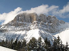
Dofinejske Predalpe
| Dofinejske Predalpe | |
|---|---|
| Préalpes du Dauphiné | |
 Grande Tête de l'Obiou | |
| Najvišja točka | |
| Vrh | Grande Tête de l'Obiou |
| Nadm. višina | 2.790 m [1] |
| Koordinate | 44°46′31″N 5°50′22″E / 44.77528°N 5.83944°E |
| Geografija | |
| Država | Francija |
| francoske regije | Rona-Alpe, Provansa-Alpe-Azurna obala |
| Gorovje | Alpe |
| Meji na | Provansalske Alpe in Predalpe, Dofinejske Alpe in Savojske Predalpe |
| Reke | Drac, Durance, Isère in Drôme |
| Geologija | |
| Orogeneza | Alpidska orogeneza |
| Tip kamnin | Sedimentne kamnines[2] |
Dofinejske Predalpe (Préalpes du Dauphiné v francoščini) je gorovje v jugozahodnem delu Alp. Nahajajo se v regiji Rona-Alpe in nekoliko v regiji Provansa-Alpe-Azurna obala (jugovzhodna Francija). Dofinejske Predalpe so osrednji del Francoskih Predalp.
Etimologija
[uredi | uredi kodo]Dauphiné (izgovarja: [dofine]) je bivša francoska pokrajina, katere območje približno ustreza temu kar so sedaj departmaji Isère, Drôme in Hautes-Alpes.
Geografija
[uredi | uredi kodo]Administrativno francoski del gorovja spada v francoske departmaje Isère, Drôme, Hautes-Alpes in minimalno v Alpes-de-Haute-Provence. Celotno območje odmaka reka Rona.
SOIUSA klasifikacija
[uredi | uredi kodo]Po SOIUSA (International Standardized Mountain Subdivision of the Alps) se gorsko območje tega dela Alp deli na naslednji način: [3]
- glavni del = Zahodne Alpe
- glavni sektor = Jugozahodne Alpe
- odsek = Dofinejske Predalpe
- koda = I / A-6
Meje
[uredi | uredi kodo]Dofinejske Predalpe mejijo na:
- Isère (sever);
- Drak, Col Bayard - ki jih povezuje z Dofinejskimi Alpami - in Durance (vzhod)
- Buech, Col de Macuègne - ki jih povezuje s Provansalskimi Alpami in Predalpami - in reko Toulourenc (jug);
- dolina Rona in Isère (zahod)
Pododseki
[uredi | uredi kodo]Delijo se v pet alpskih pododsekov:
- Dévoluy Mountains - SOIUSA koda: I / A-6.I;
- Massif Céüse-Aujour - SOIUSA koda: I / A-6.II;
- Massif du Vercors - SOIUSA koda: I / A-6.III;
- Massif du DIOIS - SOIUSA koda: I / A-6.IV;
- Massif des Baronnies - SOIUSA koda: I / A-6.V
Pomembni vrhovi
[uredi | uredi kodo]
Nekaj pomembnih vrhov:
| Ime | m | |
|---|---|---|
| Grande Tête de l'Obiou | 2.790 | |
| Grand Ferrand | 2.759 | |
| Pic de Bure | 2.709 | |
| Jocou | 2.501 | |
| Grand Veymont | 2.346 |
Pomembni prelazi
[uredi | uredi kodo]
Some notable passes of the range are:
| Ime | lokacija | tip | višina (m) |
|---|---|---|---|
| Col de la Croix Haute]] | Clelles v Lus-la-Croix-Haute | cesta | 1.179 |
| Col Bayard]] | Gap, Hautes-Alpes v Grenoble | cesta | 1.248 |
| Col du Noyer | Le Noyer, Hautes-Alpes v Saint-Étienne-en-Dévoluy | cesta | 1.664 |
Sklici
[uredi | uredi kodo]- ↑ Highest summit elevation as reported on Géoportail Arhivirano 2007-11-13 na Wayback Machine. of Institut Géographique National
- ↑ Préalpes, article on Larousse encyclopedia (on line version:www.larousse.fr/encyclopedie)
- ↑ Marazzi, Sergio (2005). Atlante Orografico delle Alpi. SOIUSA (v italijanščini). Priuli & Verlucca. ISBN 978-88-8068-273-8.
Karte
[uredi | uredi kodo]- French official cartography (Institut Géographique National - IGN); on-line version: www.geoportail.fr
Text is available under the CC BY-SA 4.0 license; additional terms may apply.
Images, videos and audio are available under their respective licenses.

